Explore the World
One Map at a Time
Geographic data, interactive maps, and tools for 250+ countries and territories. Population facts, political boundaries, and more.
Browse by Continent
Explore countries and territories across all continents
Popular Countries
Most visited country profiles


Interactive Map Tools
Free online tools for geographic calculations and exploration
Distance Calculator
Measure distances between any points on the map in km and miles.
Address Locator
Find any address on the map. Convert between addresses and coordinates.
Geocoder
Convert addresses to geographic coordinates (latitude/longitude).
Street View
Explore streets around the world with panoramic imagery.
Coordinate Finder
Get latitude and longitude coordinates for any location.
Locate Me
Find your current location on the map using GPS.
US States
Explore all 50 states and territories
Featured Maps
Curated cartographic maps covering geography, history and economy.
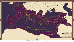
Roman Empire Maximum Extent 117 AD Map under Trajan
Italian Republic
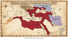
Ottoman Empire Greatest Extent 1683 Map
Republic of Turkey
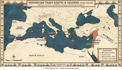
Phoenician Trade Routes and Colonies in the Mediterranean (1500-300 BC)
World
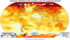
Global Temperature Change Map: 50-Year Warming & Ice Melt Trends
World
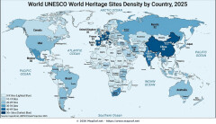
World Map: UNESCO World Heritage Sites Density by Country 2025
World
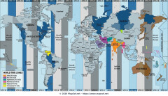
Detailed World Time Zone Map with UTC Offsets and Major Cities
World
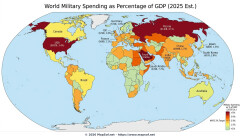
Projected 2025 World Military Spending as GDP Percentage Map
World
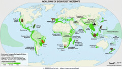
World Biodiversity Hotspots: 36 Regions of Endemism and Threat
World
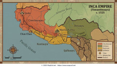
Inca Empire (Tawantinsuyu) 1525 Map: Greatest Extent Before Conquest
World
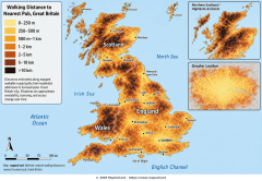
Walking Distance to the Nearest Pub Across Great Britain
United Kingdom of Great Britain and Northern Ireland
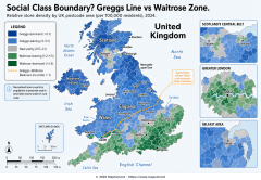
Greggs Line vs Waitrose Zone: Mapping the UK North–South Retail Divide
United Kingdom of Great Britain and Northern Ireland
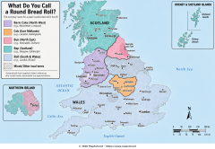
Bap, Cob, Barm or Bun? The UK Bread Roll Dialect Map
United Kingdom of Great Britain and Northern Ireland