South Carolina, US
South Carolina: Located in the southeastern United States, this state is known for its diverse landscapes, from Appalachian mountains to Atlantic beaches.
About
South Carolina is a southeastern state bounded by North Carolina, Georgia, and the Atlantic Ocean. It was one of the original 13 colonies that founded the United States.
Some key facts about South Carolina:
- Capital: Columbia
- Population: Around 5.1 million
- Area: 32,020 square miles
- Nickname: The Palmetto State
South Carolina can be divided into three main geographic regions - the Blue Ridge Mountains, the Piedmont Plateau, and the Atlantic Coastal Plain. Iconic landscape features include Myrtle Beach and Charleston Harbor.
Columbia serves as the capital while Charleston and Greenville are major economic centers known for their historic southern charm. Much of South Carolina is rural farmland. Forestry and manufacturing are also key industries.
South Carolina is steeped in history as the site of the first battle and secession of the Civil War. It has made significant contributions to blues, jazz, and beach music. The state dance is the shag.
Top attractions include Charleston's antebellum architecture, Myrtle Beach golf courses, Carolina barbecue cuisine, and cultural festivals like Spoleto USA. South Carolina experiences long humid summers and short mild winters.
In summary, South Carolina offers southern comfort through its coastal beaches, colonial history, lowcountry cuisine, and hospitable culture. It provides a beautiful window into quintessential Southern heritage and hospitality.

State Snapshot
South Carolina at a glance
South Carolina currently has 331 quality-checked populated place pages and 46 county pages linked on MapSof.
Mapped cities & towns
331
These counts use a stricter populated-place filter so the main lists stay focused on real city and town pages.
County pages
46
Open related pagesLargest city
CharlestonPopulation 139,714
Top linked places
Quick Facts about South Carolina
| Population | 5,218,040 |
| Country | United States of America, United States of America |
| Area | 82931 km2 |
| Water as percent of area | 6.12% |
| Land as percent of area | 93.88% |
| Easternmost point | Point(-78.540861111 33.850888888) |
| Northernmost point | Point(-82.390358333 35.2154) |
| Latitude & Longitude | 34.0004,-81.0001 |
| Legislative body | South Carolina General Assembly |
| Named for | Province of Carolina, south |
| Official language | English |
| Altitude | 344 feet / 105 meters |
| Capital | Columbia |
| Establishment | May 23, 1788 (238 years ago) |
| Time Zone | America/New_York, Eastern Time Zone |
| Local time | 11:38:58 (18th July 2026) |
| Weather | 95℉ Mostly Sunny then Slight Chance Showers And Thunderstorms 7-days weather |

Geography
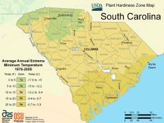
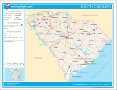
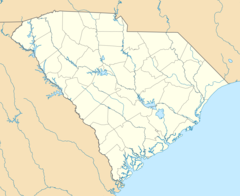
South Carolina is located at 34°0'2"N 81°0'0"W (34.0004300, -81.0000900). It has 2 neighbors: Georgia and North Carolina.
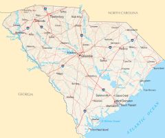
South Carolina map
The largest city of South Carolina is Charleston with a population of 139,714. Other cities include, Columbia population 132,130, North Charleston population 118,752, Mount Pleasant population 92,799 and Greenville population 72,227. See all South Carolina cities & populated places.
Largest Cities in South Carolina (more)
Cities, Towns, Villages, Neighborhoods & Other Populated Places in South Carolina.
| City Name | County | Population |
|---|---|---|
| Charleston | Charleston | 139,714 |
| Columbia | Richland | 132,130 |
| North Charleston | Charleston | 118,752 |
| Mount Pleasant | Charleston | 92,799 |
| Greenville | Greenville | 72,227 |
| Summerville | Dorchester | 53,301 |
| Goose Creek | Berkeley | 44,972 |
| Hilton Head Island | Beaufort | 39,619 |
| Sumter | Sumter | 39,439 |
| Florence | Florence | 38,467 |
| Spartanburg | Spartanburg | 37,317 |
| Hilton Head | Beaufort | 37,099 |
| Myrtle Beach | Horry | 35,555 |
| Greer | Greenville | 35,316 |
| Aiken | Aiken | 31,121 |
| Hanahan | Berkeley | 28,280 |
Show more South Carolina cities and populated places
Weather
A slight chance of showers and thunderstorms after 2pm. Mostly sunny, with a high near 95.
7-Day ForecastOfficial website of South Carolina
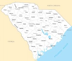
Official Website- Edgefield County
- Allendale County
- Greenwood County
- Charleston County
- Florence County
- Fairfield County
- Oconee County
- Beaufort County
- Newberry County
- Jasper County
- Spartanburg County
- Georgetown County
- Berkeley County
- Anderson County
- Lancaster County
- Greenville County
- Calhoun County
- Marion County
- Kershaw County
- Pickens County
- Dorchester County
- Chester County
- Marlboro County
- McCormick County
- Chesterfield County
- Dillon County
- Union County
- Orangeburg County
- Barnwell County
- Aiken County
- Lexington County
- Bamberg County
- Clarendon County
- Colleton County
- Cherokee County
- Horry County
- Williamsburg County
- York County
- Abbeville County
- Richland County
- Saluda County
- Laurens County
- Darlington County
- Sumter County
- Lee County
- Hampton County
Demographics
| Year | Population | % Change | Method |
|---|---|---|---|
| 1910 | 1,515,400 | - | census |
| 1920 | 1,683,724 | 10% | census |
| 1940 | 1,899,804 | 11.37% | census |
| 1950 | 2,117,027 | 10.26% | census |
| 1960 | 2,382,594 | 11.15% | census |
| 1970 | 2,590,516 | 8.03% | census |
| 1990 | 3,486,703 | 25.7% | census |
| 2000 | 4,012,012 | 13.09% | census |
| 2010 | 4,625,364 | 13.26% | census |
| 2011 | 4,671,994 | 1% | estimation process |
| 2012 | 4,717,354 | 0.96% | estimation process |
| 2013 | 4,764,080 | 0.98% | estimation process |
| 2014 | 4,823,617 | 1.23% | estimation process |
| 2015 | 4,891,938 | 1.4% | estimation process |
| 2016 | 4,957,968 | 1.33% | estimation process |
| 2017 | 5,021,268 | 1.26% | estimation process |
| 2018 | 5,084,156 | 1.24% | estimation process |
| 2019 | 5,148,714 | 1.25% | estimation process |
| 2020 | 5,218,040 | 1.33% | estimation process |
People born in South Carolina (198)
People born in South Carolina, including Confederate States Army brigadier general James Cantey, professional wrestler A.J. Styles, Confederate Army general Zachariah Cantey Deas, .
More notable people
- James Hampton (American outsider artist) he was born in 08/04/1909
- Wade Hampton I (United States general (1754-1835)) he was born in 01/01/1754
- Robert Marion (American politician (1766-1811)) he was born in 01/01/1766
- James Longstreet (Confederate Army general) he was born in 08/01/1821
- Micah Jenkins (Confederate Army general) he was born in 01/12/1835
- Samuel Maverick (American politician (1803-1870)) he was born in 23/07/1803
- Arthur Smith (American country musician, songwriter and producer) he was born in 01/04/1921
- John Hunter (American farmer and senator from Newberry, South Carolina (1750-1802)) he was born in 01/01/1750
- Gayle Rubin (American cultural anthropologist, activist, and feminist) she was born in 01/01/1949
- Velma Barfield (American serial killer) she was born in 29/10/1932
- Amos White (American trumpeter) he was born in 06/11/1889
- Guy Davenport (Novelist, short story writer, poet, illustrator, translator, teacher (1927-2005)) he was born in 23/11/1927
- Bettye Ackerman (American actress (1924-2006)) she was born in 28/02/1924
- Buck Baker (American racecar driver) he was born in 04/03/1919
- Oran M. Roberts (American politician (1815-1898)) he was born in 09/07/1815
- Derek Roddy (American musician) he was born in 28/08/1972
- Arnoldus Vanderhorst (politician (1748-1815)) he was born in 21/03/1748
- Benjamin Ryan Tillman, Jr. (American politician (1847-1918)) he was born in 11/08/1847
South Carolina Counties (more)
Greenville County

county in South Carolina, United States
Richland County

county in South Carolina, United States
Charleston County

county in South Carolina, United States of America
| County Name | Population |
|---|---|
| Greenville County | 532,486 |
| Richland County | 419,051 |
| Charleston County | 417,981 |
| Horry County | 365,449 |
| Spartanburg County | 326,205 |
| Lexington County | 303,946 |
| York County | 289,105 |
| Berkeley County | 235,987 |
| Anderson County | 204,353 |
| Beaufort County | 195,656 |
| Aiken County | 172,895 |
| Dorchester County | 165,737 |
| Florence County | 137,588 |
| Pickens County | 127,983 |
| Sumter County | 106,360 |
| Lancaster County | 100,926 |
Show more South Carolina counties
Map & Images (more maps)
Map of South Carolina Na 1
Usa South Carolina Location Map
South Carolina Flag Map
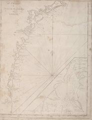
South Carolina And Georgia Historical Map
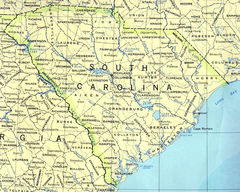
South Carolina Reference Map
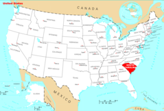
Where Is South Carolina Located
South Carolina Cities And Towns
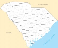
South Carolina County Map
South Carolina Reference Map
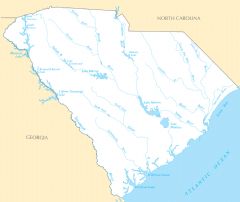
South Carolina Rivers And Lakes