Inca Empire (Tawantinsuyu) 1525 Map: Greatest Extent Before Conquest

The Realm of the Four Parts at its Zenith

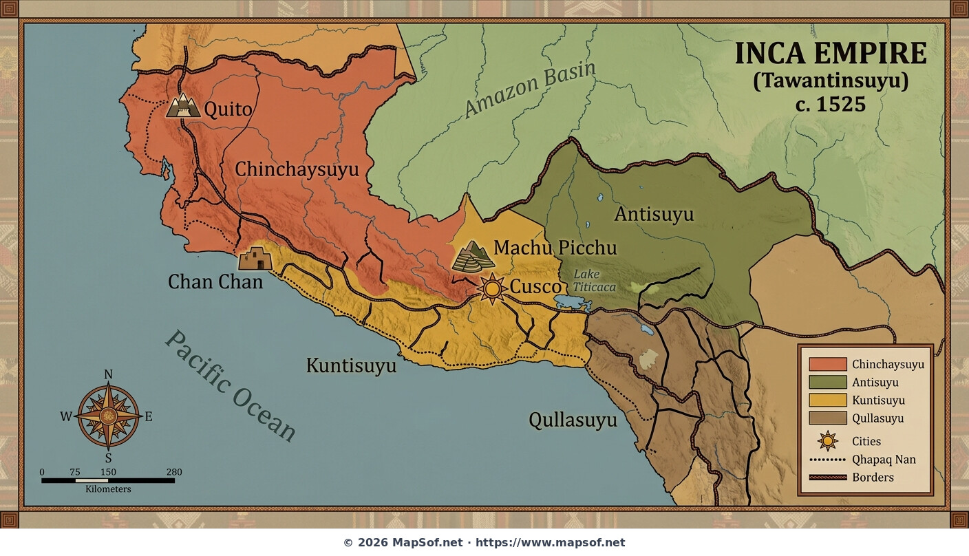
This map depicts the Inca Empire, known indigenously as Tawantinsuyu, at its greatest territorial extent around the year 1525, immediately preceding Spanish contact. Rendered with earth tones and traditional Andean design motifs, it illustrates the vast domain stretching along the Andes Mountains from modern-day southern Colombia to central Chile and Argentina. This moment captures the peak of pre-Columbian political organization in South America.

Imperial Infrastructure and Divisions

The map highlights crucial urban centers, including the imperial capital of Cusco, the northern stronghold of Quito, the expansive coastal city of Chan Chan, and the royal estate of Machu Picchu. Unifying this sprawling territory is the remarkable Qhapaq Nan, the extensive Inca road system. The empire's administrative structure is clearly delineated by color-coding the four suyus (quarters): Chinchaysuyu (north), Antisuyu (east), Cuntisuyu (west), and Collasuyu (south).

inca empire tawantinsuyu andes south america pre-columbian 1525 history cusco qhapaq nan inca roads ancient civilization
Click on the Inca Empire (Tawantinsuyu) 1525 Map: Greatest Extent Before Conquest to view it full screen. File Type: jpg, File size: 321808 bytes (314.27 KB), Map Dimensions: 1408px x 808px (100494 colors)

More World Static Maps

Ottoman Empire Map: Imperial Height & Decline (1683)
1088 x 960 - 1,314,029k - png
US State Name Origins: An Etymological Map
896 x 1152 - 1,084,019k - png
World GDP by Country 2025 Map: Top Economies and Global Economic Scale
1536 x 1024 - 1,777,090k - png
Projected 2025 World Map: International Tourist Arrivals
1408 x 768 - 733,539k - jpg
Hours of Work for a Pizza: Global Minimum Wage vs Big Mac (2024)
1536 x 1024 - 1,964,767k - png
Projected World Population Density 2025 Heat Map
1408 x 768 - 762,788k - jpg
Mongol Empire 1279 Map: The Four Khanates at Their Peak
1408 x 768 - 287,406k - jpg
Caffeine Wars: Coffee vs. Tea Consumption by Country (Per Capita)
1536 x 1024 - 1,511,270k - png
Where Sheep and Cattle Outnumber People (Global Ratios)
1536 x 1064 - 1,204,165k - png
World Map: Distribution of Major Language Families
1408 x 808 - 704,168k - jpg
Map of Alexander the Great's Conquests (334–323 BC)
1408 x 808 - 440,991k - jpg
Most Common First Names in Europe – Country-by-Country Map
1536 x 1064 - 1,981,782k - png
World Map: Coffee Production by Country & The Coffee Belt
1408 x 808 - 701,386k - jpg
Where the UK Has Resident Embassies and High Commissions (2026)
1536 x 1064 - 1,930,857k - png
Global Internet Connectivity Map: 2025 Projected Penetration Rates
1408 x 808 - 782,830k - jpg
World Map of Major Tectonic Plates, Boundaries, and Geohazards
1408 x 808 - 395,194k - jpg
World Map: Projected Proven Oil Reserves by Country, 2025
1408 x 808 - 664,332k - jpg
Dominant Electricity Sources Worldwide 2025 Forecast Map
1408 x 808 - 262,480k - jpg
2025 Global Happiness Index Map: Country Rankings & Scores
1408 x 808 - 665,170k - jpg
Global Ocean Currents Map: Warm, Cold, and Thermohaline Circulation
1408 x 808 - 774,404k - jpg
World Map: Deforestation Rates and Forest Cover (Last Decade)
1408 x 808 - 771,260k - jpg
Cold War Map 1980: NATO vs Warsaw Pact & Iron Curtain
1408 x 808 - 327,835k - jpg
Achaemenid Persian Empire Map 500 BC: Satrapies Under Darius I
1408 x 808 - 997,078k - jpg
Projected 2025 World Map: Renewable Electricity Percentage by Country
1408 x 808 - 305,711k - jpg
World Adult Literacy Rates Map 2025 Forecast
1408 x 808 - 330,922k - jpg
Global Seismic Activity Map: Major Earthquake Zones & The Ring of Fire
1408 x 808 - 394,430k - jpg
Projected World Migration Flows 2025 Map
1408 x 808 - 716,938k - jpg
Projected World CO2 Emissions Per Capita Map 2025
1408 x 808 - 359,630k - jpg
Age of Discovery: Voyages of Columbus, da Gama, Magellan & Drake
1408 x 808 - 1,083,190k - jpg
World Water Scarcity Projection Map 2025
1408 x 808 - 298,882k - jpg