Ottoman Empire Map: Imperial Height & Decline (1683)
The Ottoman Empire: Apex of Power and Seeds of Decline (1683)
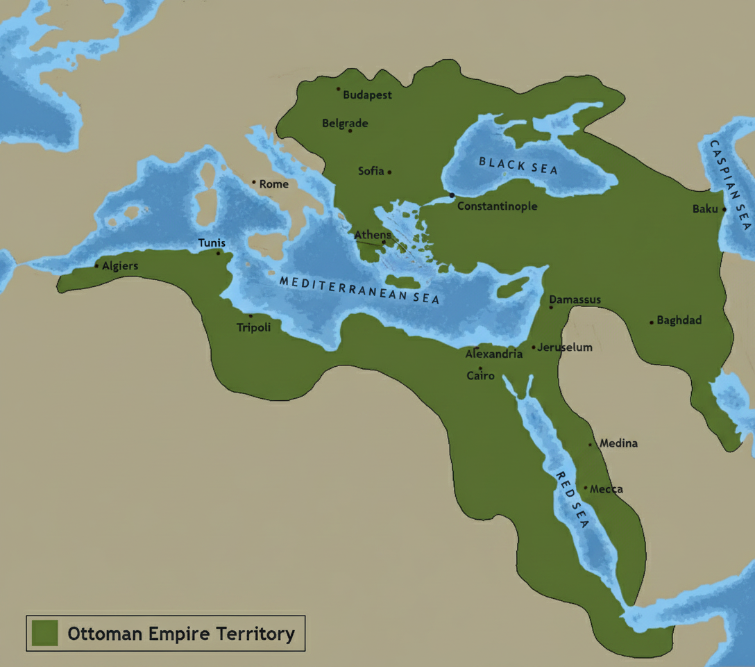
This meticulously crafted map visually represents the Ottoman Empire at its territorial zenith in 1683, a pivotal year often considered the beginning of its long decline. Spanning across Southeastern Europe, North Africa, and the Middle East, the empire's vast territories are clearly delineated, showcasing its strategic control over vital land and sea routes. Key cities like Constantinople (Istanbul), Budapest, Belgrade, Cairo, Jerusalem, Damascus, and Baghdad are accurately positioned and legibly labeled, alongside crucial bodies of water such as the Black Sea, Mediterranean Sea, Red Sea, and Caspian Sea. The map employs a refined, professional cartographic style with sharp boundaries, a harmonious color palette, and clear typography, making it an ideal resource for understanding the historical geography of this powerful empire.
Understanding the Ottoman Empire's extent in 1683 provides critical context for its subsequent history. This period, immediately following the unsuccessful Siege of Vienna, marked a turning point where the empire shifted from aggressive expansion to a more defensive posture. The map serves as an invaluable educational tool, allowing viewers to grasp the sheer scale of Ottoman imperial power and the geographical challenges inherent in governing such a diverse and expansive realm. It illustrates the culmination of centuries of conquest and lays the groundwork for comprehending the geopolitical shifts that would reshape the region in the centuries that followed.
More World Static Maps

Ottoman Empire Map: Imperial Height & Decline (1683)

US State Name Origins: An Etymological Map

World GDP by Country 2025 Map: Top Economies and Global Economic Scale

Projected 2025 World Map: International Tourist Arrivals

Hours of Work for a Pizza: Global Minimum Wage vs Big Mac (2024)

Projected World Population Density 2025 Heat Map

Mongol Empire 1279 Map: The Four Khanates at Their Peak

Caffeine Wars: Coffee vs. Tea Consumption by Country (Per Capita)

Where Sheep and Cattle Outnumber People (Global Ratios)

World Map: Distribution of Major Language Families

Map of Alexander the Great's Conquests (334–323 BC)

Most Common First Names in Europe – Country-by-Country Map

World Map: Coffee Production by Country & The Coffee Belt

Where the UK Has Resident Embassies and High Commissions (2026)

Global Internet Connectivity Map: 2025 Projected Penetration Rates

World Map of Major Tectonic Plates, Boundaries, and Geohazards

World Map: Projected Proven Oil Reserves by Country, 2025

Dominant Electricity Sources Worldwide 2025 Forecast Map

2025 Global Happiness Index Map: Country Rankings & Scores

Global Ocean Currents Map: Warm, Cold, and Thermohaline Circulation

World Map: Deforestation Rates and Forest Cover (Last Decade)

Cold War Map 1980: NATO vs Warsaw Pact & Iron Curtain

Achaemenid Persian Empire Map 500 BC: Satrapies Under Darius I

Projected 2025 World Map: Renewable Electricity Percentage by Country

World Adult Literacy Rates Map 2025 Forecast

Global Seismic Activity Map: Major Earthquake Zones & The Ring of Fire

Projected World Migration Flows 2025 Map

Projected World CO2 Emissions Per Capita Map 2025

Age of Discovery: Voyages of Columbus, da Gama, Magellan & Drake
