Mongol Empire 1279 Map: The Four Khanates at Their Peak
The Apex of Mongol Power
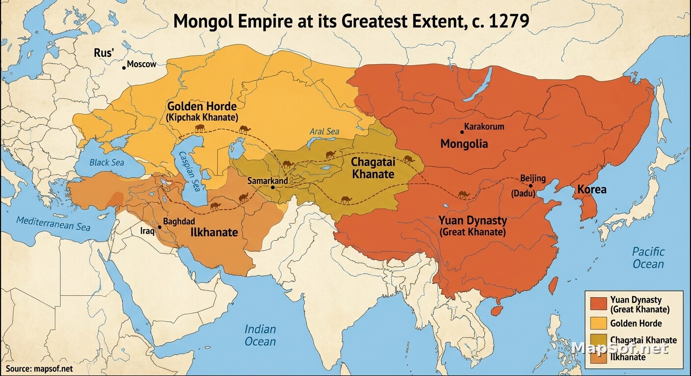
This historical map illustrates the vast **Mongol Empire in 1279**, capturing the moment of its greatest territorial extent following Kublai Khan's complete conquest of China. The empire is depicted stretching contiguously across Eurasia, forming the largest land empire in human history. The map visually segments this massive territory into the four primary successor states, or **Khanates**, using distinct warm colors for clarity: the dominant **Yuan Dynasty** in the East, the **Chagatai Khanate** in Central Asia, the **Golden Horde** ruling over Russia and Eastern Europe, and the **Ilkhanate** in the Middle East.
Beyond political boundaries, the map highlights the critical infrastructure and urban centers that connected this sprawling realm. Major capitals and pivotal cities are designated, including the ancestral capital of **Karakorum**, Kublai Khan's new imperial center at **Beijing** (Khanbaliq), alongside **Samarkand**, **Baghdad**, and **Moscow**. Furthermore, the intricate network of the **Silk Road** trade routes is clearly marked, underscoring how Mongol dominance fostered the *Pax Mongolica*, a period of relative stability that allowed commerce, ideas, and technologies to flow freely across the known world.
More World Static Maps

Ottoman Empire Map: Imperial Height & Decline (1683)

US State Name Origins: An Etymological Map

World GDP by Country 2025 Map: Top Economies and Global Economic Scale

Projected 2025 World Map: International Tourist Arrivals

Hours of Work for a Pizza: Global Minimum Wage vs Big Mac (2024)

Projected World Population Density 2025 Heat Map

Mongol Empire 1279 Map: The Four Khanates at Their Peak

Caffeine Wars: Coffee vs. Tea Consumption by Country (Per Capita)

Where Sheep and Cattle Outnumber People (Global Ratios)

World Map: Distribution of Major Language Families

Map of Alexander the Great's Conquests (334–323 BC)

Most Common First Names in Europe – Country-by-Country Map

World Map: Coffee Production by Country & The Coffee Belt

Where the UK Has Resident Embassies and High Commissions (2026)

Global Internet Connectivity Map: 2025 Projected Penetration Rates

World Map of Major Tectonic Plates, Boundaries, and Geohazards

World Map: Projected Proven Oil Reserves by Country, 2025

Dominant Electricity Sources Worldwide 2025 Forecast Map

2025 Global Happiness Index Map: Country Rankings & Scores

Global Ocean Currents Map: Warm, Cold, and Thermohaline Circulation

World Map: Deforestation Rates and Forest Cover (Last Decade)

Cold War Map 1980: NATO vs Warsaw Pact & Iron Curtain

Achaemenid Persian Empire Map 500 BC: Satrapies Under Darius I

Projected 2025 World Map: Renewable Electricity Percentage by Country

World Adult Literacy Rates Map 2025 Forecast

Global Seismic Activity Map: Major Earthquake Zones & The Ring of Fire

Projected World Migration Flows 2025 Map

Projected World CO2 Emissions Per Capita Map 2025

Age of Discovery: Voyages of Columbus, da Gama, Magellan & Drake
