Achaemenid Persian Empire Map 500 BC: Satrapies Under Darius I

The Zenith of Persian Power

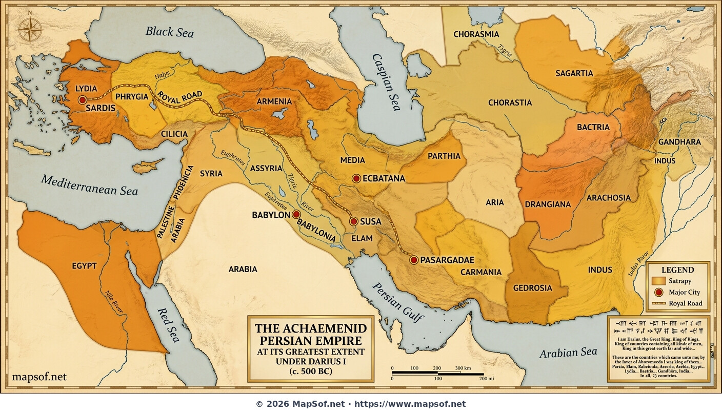
This historical map visualizes the Achaemenid Persian Empire at its greatest territorial extent around 500 BCE, during the reign of Darius the Great. Presented in warm desert and gold tones, the map illustrates the vast sweep of the first true world empire, stretching from India to the Mediterranean. It highlights the empire's sophisticated administrative structure by color-coding the distinct satrapies (provinces) that allowed efficient governance over diverse cultures and vast distances.

Imperial Infrastructure and Major Cities

Key cities vital to the empire's function are marked, including the ceremonial capital of Persepolis, administrative centers like Susa, Ecbatana, and Babylon, the ancestral site of Pasargadae, and the western hub of Sardis. The map also prominently features the legendary Royal Road, an ancient superhighway connecting Sardis to Susa, which facilitated rapid communication across the realm. An inscription attributed to Darius I is included, attesting to the scale and perceived divine sanction of his rule.

achaemenid empire ancient persia darius i 500 bc satrapies royal road ancient near east iron age persepolis imperial history
Click on the Achaemenid Persian Empire Map 500 BC: Satrapies Under Darius I to view it full screen. File Type: jpg, File size: 997078 bytes (973.71 KB), Map Dimensions: 1408px x 808px (126236 colors)

More World Static Maps

Ottoman Empire Map: Imperial Height & Decline (1683)
1088 x 960 - 1,314,029k - png
US State Name Origins: An Etymological Map
896 x 1152 - 1,084,019k - png
World GDP by Country 2025 Map: Top Economies and Global Economic Scale
1536 x 1024 - 1,777,090k - png
Projected 2025 World Map: International Tourist Arrivals
1408 x 768 - 733,539k - jpg
Hours of Work for a Pizza: Global Minimum Wage vs Big Mac (2024)
1536 x 1024 - 1,964,767k - png
Projected World Population Density 2025 Heat Map
1408 x 768 - 762,788k - jpg
Mongol Empire 1279 Map: The Four Khanates at Their Peak
1408 x 768 - 287,406k - jpg
Caffeine Wars: Coffee vs. Tea Consumption by Country (Per Capita)
1536 x 1024 - 1,511,270k - png
Where Sheep and Cattle Outnumber People (Global Ratios)
1536 x 1064 - 1,204,165k - png
World Map: Distribution of Major Language Families
1408 x 808 - 704,168k - jpg
Map of Alexander the Great's Conquests (334–323 BC)
1408 x 808 - 440,991k - jpg
Most Common First Names in Europe – Country-by-Country Map
1536 x 1064 - 1,981,782k - png
World Map: Coffee Production by Country & The Coffee Belt
1408 x 808 - 701,386k - jpg
Where the UK Has Resident Embassies and High Commissions (2026)
1536 x 1064 - 1,930,857k - png
Global Internet Connectivity Map: 2025 Projected Penetration Rates
1408 x 808 - 782,830k - jpg
World Map of Major Tectonic Plates, Boundaries, and Geohazards
1408 x 808 - 395,194k - jpg
World Map: Projected Proven Oil Reserves by Country, 2025
1408 x 808 - 664,332k - jpg
Dominant Electricity Sources Worldwide 2025 Forecast Map
1408 x 808 - 262,480k - jpg
2025 Global Happiness Index Map: Country Rankings & Scores
1408 x 808 - 665,170k - jpg
Global Ocean Currents Map: Warm, Cold, and Thermohaline Circulation
1408 x 808 - 774,404k - jpg
World Map: Deforestation Rates and Forest Cover (Last Decade)
1408 x 808 - 771,260k - jpg
Cold War Map 1980: NATO vs Warsaw Pact & Iron Curtain
1408 x 808 - 327,835k - jpg
Achaemenid Persian Empire Map 500 BC: Satrapies Under Darius I
1408 x 808 - 997,078k - jpg
Projected 2025 World Map: Renewable Electricity Percentage by Country
1408 x 808 - 305,711k - jpg
World Adult Literacy Rates Map 2025 Forecast
1408 x 808 - 330,922k - jpg
Global Seismic Activity Map: Major Earthquake Zones & The Ring of Fire
1408 x 808 - 394,430k - jpg
Projected World Migration Flows 2025 Map
1408 x 808 - 716,938k - jpg
Projected World CO2 Emissions Per Capita Map 2025
1408 x 808 - 359,630k - jpg
Age of Discovery: Voyages of Columbus, da Gama, Magellan & Drake
1408 x 808 - 1,083,190k - jpg
World Water Scarcity Projection Map 2025
1408 x 808 - 298,882k - jpg