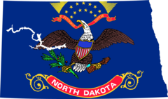
North Dakota, US
North Dakota: Located in the Upper Midwest region of the United States, this state is known for its vast plains, Badlands in the west, and agricultural industry.
About
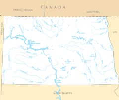
North Dakota covers 70,762 square miles, spanning rolling plains, prairie lands, and badlands. The Red River flows northward and forms North Dakota's border with Minnesota. The state has a true continental climate with extremely cold winters and hot summers.
Economy and Industries
North Dakota's economy relies heavily on agriculture, energy production, and technology. It leads the nation in the production of spring wheat, barley, sunflowers, and dry edible beans. The state has massive oil and natural gas reserves.
Growing tech industries include drones, healthcare IT, and computer programming. Major employers include Sanford Health, Microsoft, and Amazon. Tourism highlights include national parks and the rugged Badlands.
Culture and Demographics
North Dakota has approximately 760,000 residents. The top ethnic groups are German, Norwegian, and Swedish ancestry. The culture reflects traditional Midwest values along with Scandinavian and German heritage.
Education and Sports
The only Division I university is North Dakota State, whose football team has won 9 FCS championships. The NBA's Minnesota Timberwolves host games in Fargo. Ice hockey is popular within the community.
Government and Politics
The capital is Bismarck and the largest city is Fargo. The current governor is Doug Burgum, Republican. North Dakota is a conservative state that has voted Republican in presidential elections since 1968.
Conclusion
In summary, North Dakota is an agricultural and energy production powerhouse located in the Great Plains. It has extreme climates and citizens proud of their Midwestern values and European roots. Unique natural landmarks attract visitors to this sparsely populated state.

State Snapshot
North Dakota at a glance
North Dakota currently has 486 quality-checked populated place pages and 53 county pages linked on MapSof.
Mapped cities & towns
486
These counts use a stricter populated-place filter so the main lists stay focused on real city and town pages.
County pages
53
Open related pagesLargest city
BismarckPopulation 74,018
Top linked places
Quick Facts about North Dakota
| Population | 765,309 |
| Country | United States of America |
| Area | 183108 km2 |
| Water as percent of area | 2.4% |
| Land as percent of area | 97.6% |
| Easternmost point | Point(-96.55455 46.083977) |
| Latitude & Longitude | 47.5003,-100.0007 |
| Legislative body | North Dakota Legislative Assembly |
| Named for | Dakota people |
| Official language | English |
| Altitude | 1,903 feet / 580 meters |
| Capital | Bismarck |
| Establishment | November 02, 1889 (136 years ago) |
| Time Zone | UTC−06:00, America/Chicago, Central Time Zone, Mountain Time Zone |
| Local time | 12:08:30 (17th July 2026) |
| Weather | 84℉ Mostly Sunny 7-days weather |

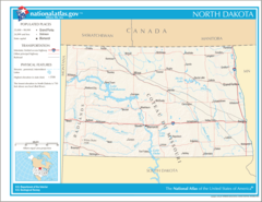
Geography
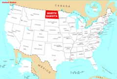
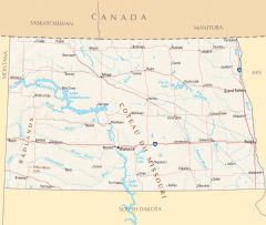
North Dakota is located at 47°30'1"N 100°0'2"W (47.5002700, -100.0006800). It has 6 neighbors: Minnesota, Montana, South Dakota, Manitoba, Northwest Territories and Saskatchewan.
North Dakota map
The largest city of North Dakota is Bismarck with a population of 74,018. Other cities include, Minot population 47,428, West Fargo population 38,194, Dickinson population 23,527 and Jamestown population 14,930. See all North Dakota cities & populated places.
Largest Cities in North Dakota (more)
Cities, Towns, Villages, Neighborhoods & Other Populated Places in North Dakota.
| City Name | County | Population |
|---|---|---|
| Bismarck | Burleigh | 74,018 |
| Minot | Ward | 47,428 |
| West Fargo | Cass | 38,194 |
| Dickinson | Stark | 23,527 |
| Jamestown | Stutsman | 14,930 |
| Watford City | McKenzie | 7,835 |
| Wahpeton | Richland | 7,728 |
| Devils Lake | Ramsey | 7,229 |
| Valley City | Barnes | 6,323 |
| Beulah | Mercer | 3,128 |
| Horace | Cass | 3,128 |
| Stanley | Mountrail | 2,708 |
| New Town | Mountrail | 2,592 |
| Rugby | Pierce | 2,566 |
| Mekinock | Grand Forks | 2,387 |
| Hazen | Mercer | 2,332 |
Show more North Dakota cities and populated places
Weather
Mostly sunny, with a high near 84. North wind 13 to 17 mph, with gusts as high as 25 mph.
7-Day ForecastOfficial website of North Dakota
Official Website- McKenzie County
- Adams County
- Richland County
- Stark County
- Traill County
- Williams County
- Sargent County
- Sheridan County
- Mountrail County
- Rolette County
- Hettinger County
- Renville County
- Morton County
- Cavalier County
- McIntosh County
- Pembina County
- Golden Valley County
- Bowman County
- Stutsman County
- Bottineau County
- Griggs County
- Logan County
- Ramsey County
- Ward County
- Burke County
- Eddy County
- Nelson County
- Pierce County
- Dickey County
- Billings County
- Emmons County
- Cass County
- Dunn County
- Oliver County
- LaMoure County
- Towner County
- Sioux County
- Grand Forks County
- Barnes County
- Kidder County
- Wells County
- McHenry County
- McLean County
- Grant County
- Benson County
- Mercer County
- Foster County
- Burleigh County
- Steele County
- Divide County
- Walsh County
- Ransom County
- Slope County
Demographics
| Year | Population | % Change | Method |
|---|---|---|---|
| 1910 | 577,056 | - | census |
| 1920 | 646,872 | 10.79% | census |
| 1930 | 680,845 | 4.99% | census |
| 1940 | 641,935 | -6.06% | census |
| 1950 | 619,636 | -3.6% | census |
| 1960 | 632,446 | 2.03% | census |
| 1970 | 617,761 | -2.38% | census |
| 1980 | 652,717 | 5.36% | census |
| 1990 | 638,800 | -2.18% | census |
| 2000 | 642,200 | 0.53% | census |
| 2010 | 672,591 | 4.52% | census |
| 2011 | 685,225 | 1.84% | estimation process |
| 2012 | 701,176 | 2.27% | estimation process |
| 2013 | 722,036 | 2.89% | estimation process |
| 2014 | 737,401 | 2.08% | estimation process |
| 2015 | 754,066 | 2.21% | estimation process |
| 2016 | 754,434 | 0.05% | estimation process |
| 2017 | 754,942 | 0.07% | estimation process |
| 2018 | 758,080 | 0.41% | estimation process |
| 2019 | 762,062 | 0.52% | estimation process |
| 2020 | 765,309 | 0.42% | estimation process |
People born in North Dakota (69)
People born in North Dakota, including actress Ann Sothern, Canadian track and field athlete Ethel Catherwood, composer James Ployhar, .
More notable people
- Lawrence Welk (American musician, bandleader, and impresario) he was born in 11/03/1903
- Fred M. MacLean (set decorator) he was born in 09/07/1898
- Frederic Knudtson (American film editor) he was born in 09/04/1906
- Patrick E. Haggerty (American businessman) he was born in 17/03/1914
- William Theodore Mulloy (Catholic bishop) he was born in 09/11/1892
- Rhoda Janzen (Poet and memoirist) she was born in 01/01/2000
- Walter Richard Miles (American psychologist) he was born in 01/01/1885
- William Jennings Gardner (American football player and coach, basketball coach, baseball coach, college athletics administrator, law-enforcement agent (1884-1965)) he was born in 23/01/1884
- Carl Ben Eielson (American aviator and explorer) he was born in 20/01/1897
- Dorothy Adams (American actress (1900-1988)) she was born in 08/01/1900
- Larry Watson (American writer) he was born in 01/01/1947
- Malachi Ritscher (American musician) he was born in 13/01/1954
- Dave Bickler (American singer) he was born in 01/03/1953
- Elinor Denniston (American author who wrote under a number of pseudonyms) she was born in 20/09/1900
- Annie Herring (American singer) she was born in 22/09/1945
- Bob Stenehjem (American politician) he was born in 12/01/1952
- Carol Thurston (American actress) she was born in 27/09/1920
- Charles F. Wald (United States Air Force General) he was born in 01/01/1948
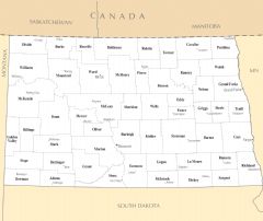
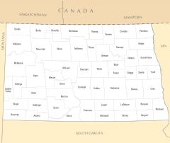
North Dakota Counties (more)
Cass County

county in Minnesota, United States
Burleigh County

county in North Dakota, United States
Grand Forks County

county in North Dakota, United States
| County Name | Population |
|---|---|
| Cass County | 183,904 |
| Burleigh County | 96,212 |
| Grand Forks County | 69,481 |
| Ward County | 68,466 |
| Williams County | 38,700 |
| Stark County | 32,107 |
| Morton County | 31,503 |
| Stutsman County | 20,498 |
| Richland County | 16,156 |
| McKenzie County | 15,242 |
| Rolette County | 14,165 |
| Ramsey County | 11,388 |
| Mountrail County | 10,502 |
| Walsh County | 10,437 |
| Barnes County | 10,402 |
| McLean County | 9,416 |
Show more North Dakota counties
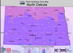
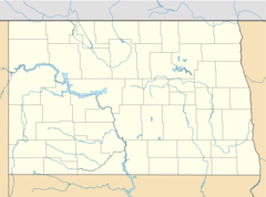
Map & Images (more maps)
Map of North Dakota Na 1
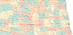
North Dakota Map Counties And Cities
Usa North Dakota Location Map
North Dakota Flag Map
Where Is North Dakota Located
North Dakota Cities And Towns
North Dakota County Map
North Dakota Reference Map
North Dakota Rivers And Lakes