Manitoba, CA
Manitoba: province of Canada
About
Quick Facts about Manitoba
| Population | 1,343,371 |
| Country | Canada |
| Postal code | R |
| Area | 647797 km2 |
| Official name | Manitoba, Manitoba |
| Continent | North America |
| Easternmost point | Point(-89.0 56.848498888) |
| Northernmost point | Point(-99.0 60.0) |
| Latitude & Longitude | 55.0002,-97.0005 |
| Legislative body | Legislature of Manitoba |
| Named for | Lake Manitoba Narrows |
| Official language | English |
| Capital | Fort Garry, Winnipeg |
| Establishment | July 15, 1870 (155 years ago) |
| Time Zone | America/Winnipeg, Central Time Zone |
| Local time | 01:06:28 (27th June 2026) |
Geography
Manitoba is located at 55°0'1"N 97°0'2"W (55.000191905, -97.00049444). It has 6 neighbors: Minnesota, North Dakota, Northwest Territories, Nunavut, Ontario and Saskatchewan.
Manitoba map
Click "full screen"  icon to open full mode. View satellite images
Official website of Manitoba
Official WebsiteDemographics
| Year | Population | % Change | Method |
|---|---|---|---|
| 1871 | 25,228 | - | census |
| 1881 | 62,260 | 59.48% | census |
| 1891 | 152,506 | 59.18% | census |
| 1901 | 255,211 | 40.24% | census |
| 1911 | 461,394 | 44.69% | census |
| 1921 | 610,118 | 24.38% | census |
| 1931 | 700,139 | 12.86% | census |
| 1941 | 729,744 | 4.06% | census |
| 1951 | 776,541 | 6.03% | census |
| 1956 | 850,040 | 8.65% | census |
| 1961 | 921,686 | 7.77% | census |
| 1966 | 963,066 | 4.3% | census |
| 1971 | 988,247 | 2.55% | census |
| 1976 | 1,021,506 | 3.26% | census |
| 2011 | 1,208,268 | 15.46% | census |
| 2015 | 1,289,792 | 6.32% | estimation process |
| 2016 | 1,278,365 | -0.89% | census |
| 2017 | 1,343,371 | 4.84% | estimation process |
Manitoba Counties
| County Name | Population |
|---|
Map & Images (more maps)
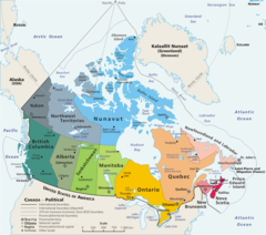
Map Canada Political 3
1280 x 1128
- 185,072k -
png