Active Volcanoes of the World: Danger Levels & Ring of Fire Map

Global Volcanic Activity Visualized

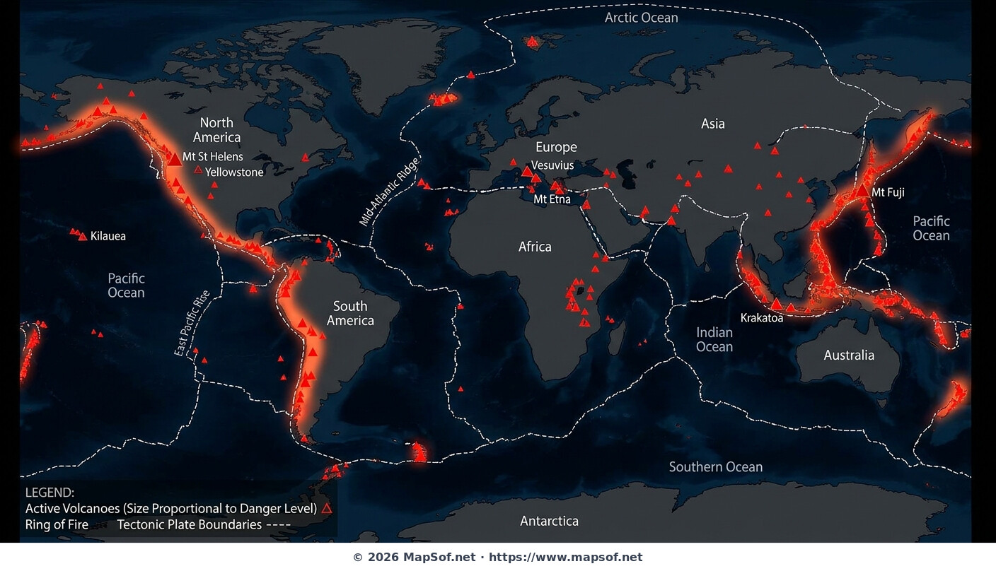
This dramatic world map provides a visual overview of currently active volcanoes across the globe, set against a dark background for emphasis. Volcanic locations are marked with red triangle symbols, offering an immediate sense of global distribution. A central focus of the map is the prominent highlighting of the Ring of Fire, the intense zone of seismic and volcanic activity encircling the Pacific Ocean Basin.

Tectonics and Danger Levels

To illustrate the geological drivers of this activity, major tectonic plate boundaries are indicated with dashed lines. The map also incorporates data on potential hazards; the size of each red triangle is proportional to the volcano's estimated danger level. Several historically significant and well-known volcanoes are explicitly labeled, including Mt Vesuvius, Krakatoa, Mt Fuji, the Yellowstone Caldera, Mt Etna, Kilauea, and Mt St Helens.

volcanoes active volcanoes ring of fire tectonic plates natural hazards geology earth science pacific rim magma geography
Click on the Active Volcanoes of the World: Danger Levels & Ring of Fire Map to view it full screen. File Type: jpg, File size: 265120 bytes (258.91 KB), Map Dimensions: 1408px x 808px (63908 colors)

More World Static Maps

Ottoman Empire Map: Imperial Height & Decline (1683)
1088 x 960 - 1,314,029k - png
US State Name Origins: An Etymological Map
896 x 1152 - 1,084,019k - png
World GDP by Country 2025 Map: Top Economies and Global Economic Scale
1536 x 1024 - 1,777,090k - png
Projected 2025 World Map: International Tourist Arrivals
1408 x 768 - 733,539k - jpg
Hours of Work for a Pizza: Global Minimum Wage vs Big Mac (2024)
1536 x 1024 - 1,964,767k - png
Projected World Population Density 2025 Heat Map
1408 x 768 - 762,788k - jpg
Mongol Empire 1279 Map: The Four Khanates at Their Peak
1408 x 768 - 287,406k - jpg
Caffeine Wars: Coffee vs. Tea Consumption by Country (Per Capita)
1536 x 1024 - 1,511,270k - png
Where Sheep and Cattle Outnumber People (Global Ratios)
1536 x 1064 - 1,204,165k - png
World Map: Distribution of Major Language Families
1408 x 808 - 704,168k - jpg
Map of Alexander the Great's Conquests (334–323 BC)
1408 x 808 - 440,991k - jpg
Most Common First Names in Europe – Country-by-Country Map
1536 x 1064 - 1,981,782k - png
World Map: Coffee Production by Country & The Coffee Belt
1408 x 808 - 701,386k - jpg
Where the UK Has Resident Embassies and High Commissions (2026)
1536 x 1064 - 1,930,857k - png
Global Internet Connectivity Map: 2025 Projected Penetration Rates
1408 x 808 - 782,830k - jpg
World Map of Major Tectonic Plates, Boundaries, and Geohazards
1408 x 808 - 395,194k - jpg
World Map: Projected Proven Oil Reserves by Country, 2025
1408 x 808 - 664,332k - jpg
Dominant Electricity Sources Worldwide 2025 Forecast Map
1408 x 808 - 262,480k - jpg
2025 Global Happiness Index Map: Country Rankings & Scores
1408 x 808 - 665,170k - jpg
Global Ocean Currents Map: Warm, Cold, and Thermohaline Circulation
1408 x 808 - 774,404k - jpg
World Map: Deforestation Rates and Forest Cover (Last Decade)
1408 x 808 - 771,260k - jpg
Cold War Map 1980: NATO vs Warsaw Pact & Iron Curtain
1408 x 808 - 327,835k - jpg
Achaemenid Persian Empire Map 500 BC: Satrapies Under Darius I
1408 x 808 - 997,078k - jpg
Projected 2025 World Map: Renewable Electricity Percentage by Country
1408 x 808 - 305,711k - jpg
World Adult Literacy Rates Map 2025 Forecast
1408 x 808 - 330,922k - jpg
Global Seismic Activity Map: Major Earthquake Zones & The Ring of Fire
1408 x 808 - 394,430k - jpg
Projected World Migration Flows 2025 Map
1408 x 808 - 716,938k - jpg
Projected World CO2 Emissions Per Capita Map 2025
1408 x 808 - 359,630k - jpg
Age of Discovery: Voyages of Columbus, da Gama, Magellan & Drake
1408 x 808 - 1,083,190k - jpg
World Water Scarcity Projection Map 2025
1408 x 808 - 298,882k - jpg