Indonesia (Republic of Indonesia), ID
Indonesia: This Southeast Asian nation, situated between the Indian and Pacific Oceans, is the world's largest island country.
About

Country Snapshot
Republic of Indonesia at a glance
Republic of Indonesia currently has 279 quality-checked populated place pages and 33 state or regional pages linked on MapSof.
Mapped cities & towns
279
These counts use a stricter populated-place filter so the main lists stay focused on real city and town pages.
States & regions
33
Open related pagesLargest city
JakartaPopulation 10,348,348
Top linked places
Quick Facts about Republic of Indonesia
| Population | 284,438,782 |
| Country | Indonesia |
| Different from | Q19435393 |
| Plate code | RI |
| Area | 1904570 km2 |
| Official name | Indonésia, Republik Indonesia, Indonesia, la République d’Indonésie |
| Continent | Asia |
| Easternmost point | Point(141.01955295 -9.12690641) |
| Northernmost point | Point(95.22 5.9) |
| Latitude & Longitude | -5.0000,120.0000 |
| Legislative body | People's Consultative Assembly |
| Official language | Indonesian |
| Capital | Yogyakarta, Bukittinggi, Jakarta, Jakarta |
| Establishment | August 17, 1945 (80 years ago) |
| Time Zone | Indonesia Central Standard Time, Indonesia Central Standard Time, Indonesia Western Standard Time |
| Local time | 19:23:23 (18th July 2026) |

Geography
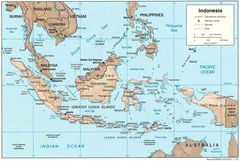
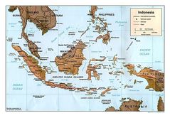
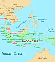
Republic of Indonesia is located at 5°0'0"S 120°0'0"E (-5.0000000, 120.0000000). It has 10 neighbors: India, Palau, Vietnam, Thailand, Philippines, Malaysia, Singapore, East Timor, Australia and Papua New Guinea.
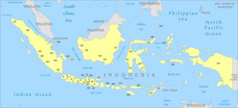
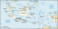
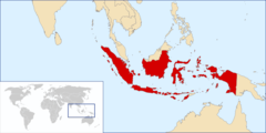
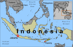
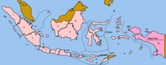
Indonesia map
The largest city of Republic of Indonesia is Jakarta with a population of 10,348,348. Other cities include, Surabaya population 4,975,000, Bandung population 2,394,873, Medan population 1,750,971 and Semarang population 1,621,384. See all Republic of Indonesia cities & populated places.
Official website of Republic of Indonesia
Official WebsiteCompare Republic of Indonesia with
- North Kalimantan
- West Papua
- Maluku
- Central Sulawesi
- West Java
- Bali
- Central Kalimantan
- West Kalimantan
- South Sumatra
- East Nusa Tenggara
- Gorontalo
- South Kalimantan
- Riau Islands
- Aceh
- Special Region of Yogyakarta
- Papua
- Central Java
- East Kalimantan
- North Sulawesi
- Jambi
- South Sulawesi
- Riau
- East Java
- Jakarta
- Bangka Belitung Islands
- West Sulawesi
- West Sumatra
- Southeast Sulawesi
- North Maluku
- Lampung
- West Nusa Tenggara
- Bengkulu
- Banten
- North Sumatra
Demographics
| Year | Population | % Change | Method |
|---|---|---|---|
| 1960 | 88,692,697 | - | estimation process |
| 1961 | 90,860,197 | 2.39% | estimation process |
| 1962 | 93,101,152 | 2.41% | estimation process |
| 1963 | 95,420,835 | 2.43% | estimation process |
| 1964 | 97,828,538 | 2.46% | estimation process |
| 1965 | 100,329,810 | 2.49% | estimation process |
| 1966 | 102,924,506 | 2.52% | estimation process |
| 1967 | 105,605,766 | 2.54% | estimation process |
| 1968 | 108,364,330 | 2.55% | estimation process |
| 1969 | 111,187,930 | 2.54% | estimation process |
| 1970 | 114,066,887 | 2.52% | estimation process |
| 1971 | 116,996,006 | 2.5% | estimation process |
| 1972 | 119,974,444 | 2.48% | estimation process |
| 1973 | 123,002,081 | 2.46% | estimation process |
| 1974 | 126,080,548 | 2.44% | estimation process |
| 1975 | 129,210,098 | 2.42% | estimation process |
| 1976 | 132,385,413 | 2.4% | estimation process |
| 1977 | 135,601,258 | 2.37% | estimation process |
| 1978 | 138,857,752 | 2.35% | estimation process |
| 1979 | 142,156,086 | 2.32% | estimation process |
| 1980 | 145,494,452 | 2.29% | estimation process |
| 1981 | 148,872,395 | 2.27% | estimation process |
| 1982 | 152,280,731 | 2.24% | estimation process |
| 1983 | 155,698,247 | 2.19% | estimation process |
| 1984 | 159,097,735 | 2.14% | estimation process |
| 1985 | 162,458,871 | 2.07% | estimation process |
| 1986 | 165,772,077 | 2% | estimation process |
| 1987 | 169,039,084 | 1.93% | estimation process |
| 1988 | 172,265,107 | 1.87% | estimation process |
| 1989 | 175,460,614 | 1.82% | estimation process |
| 1990 | 178,633,239 | 1.78% | estimation process |
| 1991 | 181,786,329 | 1.73% | estimation process |
| 1992 | 184,916,848 | 1.69% | estimation process |
| 1993 | 188,019,278 | 1.65% | estimation process |
| 1994 | 191,085,673 | 1.6% | estimation process |
| 1995 | 194,112,556 | 1.56% | estimation process |
| 1996 | 197,097,887 | 1.51% | estimation process |
| 1997 | 200,050,444 | 1.48% | estimation process |
| 1998 | 202,990,922 | 1.45% | estimation process |
| 1999 | 205,946,831 | 1.44% | estimation process |
| 2000 | 208,938,698 | 1.43% | estimation process |
| 2001 | 211,970,371 | 1.43% | estimation process |
| 2002 | 215,038,285 | 1.43% | estimation process |
| 2003 | 218,145,617 | 1.42% | estimation process |
| 2004 | 221,293,797 | 1.42% | estimation process |
| 2005 | 224,480,901 | 1.42% | estimation process |
| 2006 | 227,709,821 | 1.42% | estimation process |
| 2007 | 230,972,808 | 1.41% | estimation process |
| 2008 | 234,243,489 | 1.4% | estimation process |
| 2009 | 237,486,894 | 1.37% | estimation process |
| 2010 | 240,676,485 | 1.33% | estimation process |
| 2011 | 243,801,639 | 1.28% | estimation process |
| 2012 | 246,864,191 | 1.24% | estimation process |
| 2013 | 249,865,631 | 1.2% | estimation process |
| 2014 | 255,129,004 | 2.06% | (Worldbank) |
| 2015 | 258,383,256 | 1.26% | (Worldbank) |
| 2016 | 261,115,456 | 1.05% | project management estimation |
| 2017 | 263,991,379 | 1.09% | estimation process |
| 2018 | 267,663,435 | 1.37% | (Worldbank) |
| 2019 | 270,625,568 | 1.09% | estimation process |
| 2026 | 284,438,782 | 4.86% |
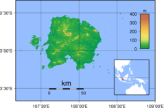
Map & Images (more maps)
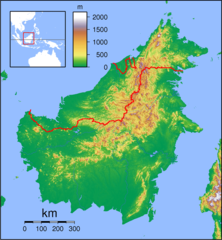
Borneo Locator Topography
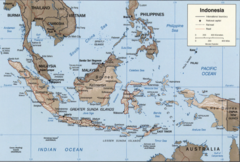
Indonesia 2002 Cia Map
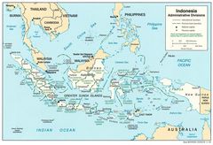
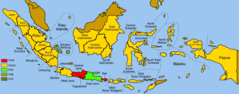
Indonesia Adminstrative Districts
Indonesia License Plates Map
Indonesia Map
Indonesia Map 1
Indonesia Map Physical
Indonesia Overview Map
Location Indonesia
Map of Indonesia
Bojonegoro Map From Us Army Map Service
1955 Indonesian Electoral Regions
2004electionsindonesia
Aceh Dati2l
Ausseis 2
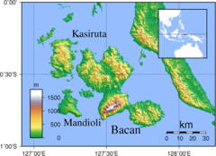
Bacan Topography
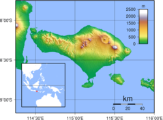
Bali Topography
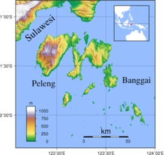
Banggai Islands Topography
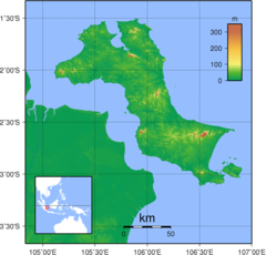
Bangka Topography
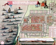
Batavia, C De Jonghe (1740)