West Bank, West Bank
West Bank: landlocked territory near the Mediterranean coast of Western Asia
About
State Snapshot
West Bank at a glance
West Bank currently has 142 quality-checked populated place pages and 4 county pages linked on MapSof.
Mapped cities & towns
142
These counts use a stricter populated-place filter so the main lists stay focused on real city and town pages.
County pages
4
Open related pagesLargest city
HebronPopulation 160,470
Top linked places
Quick Facts about West Bank
| Country | State of Palestine, Israel, Palestinian National Authority |
| State | West Bank (Palestinian Territory) |
| Different from | Judea and Samaria Area |
| Area | 5860 km2 |
| Has part | Judea and Samaria Area, East Jerusalem |
| Latitude & Longitude | 31.6667,35.2500 |
| Named for | west |
| Capital | Ramallah |
| Establishment | January 01, 1949 (77 years ago) |
| Time Zone | Asia/Hebron |
| Local time | 03:05:35 (16th July 2026) |
Geography
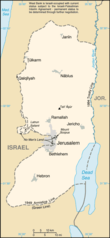
West Bank is located at 31°40'0"N 35°15'0"E (31.6666700, 35.2500000). It has 2 neighbors: Jordan and Israel.
West Bank map
The largest city of West Bank is Hebron with a population of 160,470. Other cities include, Nablus population 156,906, Ţūlkarm population 44,169, Qalqīlyah population 43,212 and Yaţţā population 41,425. See all West Bank cities & populated places.
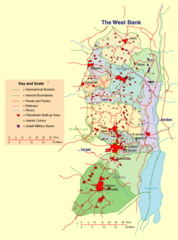
Map & Images (more maps)
West Bank Map
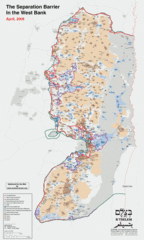
West Bank Separation Barrier
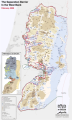
Separation Barrier Map West Bank