Trenton, Ohio
Trenton: city in Ohio
About
Trenton is a city located in the county of Butler in the U.S. state of Ohio. Its population at the 2010 census was 2,190 and a population density of 185 people per km². After 10 years in 2020 city had an estimated population of 2,691 inhabitants.
The city of Trenton is a small town in Butler County, Ohio. It was originally located in Madison Township, but in 2014 it annexed land from Wayne Township, increasing its size by nearly 50%.
The city was originally known as "Sugar Creek," named after a tributary of the Great Miami River that flows through it. In 1812, William Trent established a trading post here and later built a house on the site of what is now the downtown area. He donated land for schools and churches and was one of the founders of Miami University in Oxford, Ohio. In 1814 he built Fort Trenton to protect settlers from Indians during an outbreak of cholera.
In 1838, when land north of Middletown became available for sale by the government because it had not been settled fast enough under its original terms as part of a land grant from Congress given to veterans after the Revolutionary War (1775-1783), many people from other areas moved in and established new farms or businesses. Many more people began moving into this area after completion of the Cincinnati & Muskingum Valley Railroad (1842) which provided easy access to markets in Cincinnati. This led to rapid growth throughout Butler County which had a population of 5,000 by.
The population of Trenton is currently 11,869 people, with an estimated 2020 population of 13,046. The median age of residents is 35 years old.
Trenton has a diversified economy with many businesses operating within the city limits. These include Allstate Insurance Company and TriHealth Medical Center. The largest employer in Trenton is the General Motors facility, which produces the Chevrolet Cruze compact car.
Trenton is known for its high quality of life and excellent public schools. The city has been named one of America's 100 Best Places to Live by Money Magazine.

Quick Facts about Trenton
| Population | 2,691 (2020) |
| Country | United States of America |
| State | Ohio (United States) |
| County | Butler County |
| Postal code | 45067 |
| Area | 11.82 km2 |
| Latitude & Longitude | 39.4809,-84.4577 |
| Altitude | 650 feet / 198 meters |
| Time Zone | America/New_York |
| Local time | 17:57:13 (14th July 2026) |
| Density | 228 Pop. per km² as of 2020 |
| Population growth | 18.62% (2010-2020) |
| Weather | 90℉ Sunny 7-days weather |

Geography
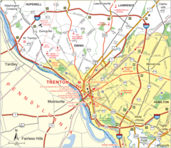
Trenton is located at 39°28'51"N 84°27'28"W (39.4808900, -84.4577200).
Trenton map
Official website of Trenton
Official WebsiteDemographics
The population of Trenton increased by 18.62% in 10 years.
| Year | Population | % Change | Method |
|---|---|---|---|
| 2010 | 2,190 | - | census |
| 2011 | 2,239 | 2.19% | estimation process |
| 2012 | 2,275 | 1.58% | estimation process |
| 2013 | 2,331 | 2.4% | estimation process |
| 2014 | 2,391 | 2.51% | estimation process |
| 2015 | 2,441 | 2.05% | estimation process |
| 2016 | 2,493 | 2.09% | estimation process |
| 2017 | 2,538 | 1.77% | estimation process |
| 2018 | 2,597 | 2.27% | estimation process |
| 2019 | 2,639 | 1.59% | estimation process |
| 2020 | 2,691 | 1.93% | estimation process |
Best Things to Do in Trenton
1Chrisholm MetroPark
2070 Woodsdale Rd, Trenton, OH 45067, United States View details
Phone: +15138675835 | Website available
Services and Civic Places in Trenton
1City of Trenton
11 E State St, Trenton, OH 45067 View details
Phone: +15139886304 | Website available
Nearby Schools and Colleges
Schools and campuses linked to Trenton, OH. Select a name to open its map and contact details.
| Code | Name | City | ZIP |
|---|---|---|---|
| 201496 | Butler Technology and Career Development Schools | Monroe (OH) | 45050 |
Nearby Transit Stations (4)
Rail and bus stations connected to Trenton, OH. Select a station to open its map and address details.
| Code | Name | Address | Type |
|---|---|---|---|
| CIG | Cincinnati, OH | 1005 Gilbert Avenue | BUS |
| CIN | Cincinnati Museum Center at Union Terminal | 1301 Western Ave. | RAIL |
| COI | Connersville station | 1012 Eastern Avenue | RAIL |
| MAY | Maysville | West Front St & Rosemary Clooney St | RAIL |
Closest post offices linked to Trenton.
| Post Office Name | City | ZIP |
|---|---|---|
| Trenton Post Office | Trenton (OH) | 45067 |
Other places with the same name (17)
- Trenton, New Jersey The capital of New Jersey. with a population of 82,957 people.
- Trenton, Michigan city in Michigan with a population of 18,031 people.
- Trenton, Missouri city in Missouri with a population of 5,620 people.
- Trenton, Wisconsin human settlement in Dodge County, Wisconsin, United States of America with a population of 4,747 people.
- Trenton, Tennessee city in Gibson County, Tennessee, United States with a population of 4,147 people.
- Trenton, Illinois city in Illinois with a population of 2,566 people.
- Trenton, Florida town in Florida with a population of 2,188 people.
- Trenton, Georgia city in Dade County, Georgia, United States of America with a population of 2,153 people.
- Trenton, Maine town in Maine with a population of 1,568 people.
- Trenton, North Dakota unincorporated community in North Dakota with a population of 762 people.
- Trenton, Texas city in Texas, United States with a population of 701 people.
- Trenton, Utah town in Cache County, Utah, United States with a population of 573 people.
- Trenton, Nebraska village in Nebraska with a population of 533 people.
- Trenton, Kentucky city in Kentucky with a population of 378 people.
- Trenton, North Carolina town in North Carolina with a population of 274 people.
- Trenton, Kansas human settlement in Kansas, United States of America with a population of 247 people.
- Trenton, South Carolina town in South Carolina with a population of 200 people.
Other cities in Butler County
Cities, towns, neighborhoods & other populated places in Butler County , OH. (more)
| City Name | Population | Title |
|---|---|---|
| Hamilton | 62,148 | The most populous city in Butler County, Ohio. |
| Middletown | 46,140 | The most populous city in Butler County, Ohio. |
| Upper Arlington | 35,369 | City in Ohio |
| Oxford | 23,535 | City in Butler County, Ohio, United States of America |
| Lemon | 15,647 | Township of Ohio |
| Monroe | 14,183 | City in Ohio, United States |
| Macedonia | 12,029 | City in Summit County, Ohio, United States |
| Beckett Ridge | 9,187 | Census-designated place in Butler County, Ohio |
| Mayfield | 3,347 | Village in Cuyahoga County, Ohio, United States of America |
| Reily | 2,808 | Township of Ohio |
| New Miami | 2,395 | City in Butler County, Ohio, United States of America |
| Wetherington | 1,302 | Census-designated place in Butler County, Ohio |
| Fairfield | 1,091 | City in Ohio, United States |
| Auburn | 1,043 | Township in Tuscarawas County, Ohio |
| Seven Mile | 789 | Village in Butler County, Ohio |
| Millville | 737 | Village in Ohio, United States |
Distance to Other Cities
Trenton distances to largest Ohio cities
Map & Images (more maps)