How far is Port Saint Lucie, FL from Monticello, FL?
The driving distance from Port Saint Lucie, FL to Monticello, FL is about 352.1 miles (566.6 km), with a travel time of about 06h 23m by car.
- The straight-line flight distance is about 309.5 miles (498.1 km).
- For a round trip, plan for roughly 12h 46m of driving time before adding stops, traffic, or weather delays.
- A comfortable departure window is usually 6:00 AM to 7:30 AM EDT.
Reverse, save, or send this route
This drive is better planned with a longer stop or an overnight stay. Copy the route link, send it to another device, or print a clean version before you head out.
This drive is better planned with a longer stop or an overnight stay.
Flight Distance
Driving Distance
Gas Cost Calculator
Leave and Arrive Planner
Pick a departure time to see your estimated arrival and same-day return window.
Drive time stays fixed at 06h 23m.
Starting early still helps, but most travelers will want a longer stop or an overnight stay on a route this long.
You are leaving earlier than the recommended window, which gives you extra margin for breaks and traffic.
Halfway Point
A useful midpoint for breaks, coffee, or meeting in the middle.
City in Florida
Route Weather Snapshot
Check the forecast at both ends before you head out.
Chance Showers And Thunderstorms
Mostly Clear
Driving Route Map
The map below follows the saved road route between Port Saint Lucie and Monticello.
Turn-by-Turn Driving Directions
Step-by-step road directions between Port Saint Lucie and Monticello.
-
1
Start on Southwest Carter Avenue
66 m · 11 sec · Southwest Carter Avenue
-
2
Turn right onto Southeast Airoso Boulevard
1.6 mi · 3 min · Southeast Airoso Boulevard
-
3
Turn right onto Southwest Port Saint Lucie Boulevard
1.3 km · 1 min · Southwest Port Saint Lucie Boulevard
-
4
Turn left onto Southwest Bayshore Boulevard
560 ft · 22 sec · Southwest Bayshore Boulevard
-
5
Take the ramp straight toward Florida's Turnpike Toll
2787 ft · 1 min
-
6
Keep slight right to continue on Orlando, Florida's Turnpike North
1842 ft · 45 sec
-
7
Merge slight left onto Florida's Turnpike
164.8 mi · 2 hr 57 min · Florida's Turnpike
-
8
Keep slight left to continue on Florida's Turnpike
1281 ft · 16 sec · Florida's Turnpike
-
9
Merge slight left
106.9 mi · 1 hr 55 min
-
10
Take the exit slight right toward I 10: Jacksonville, Tallahassee
820 ft · 16 sec
-
11
Keep slight left to continue on I 10 West: Tallahassee
1569 ft · 30 sec
-
12
Merge slight right
70.9 mi · 1 hr 16 min
-
13
Take the exit slight right toward US 19: Monticello, Perry, Thomasville
1436 ft · 35 sec
-
14
Turn right onto Florida Georgia Parkway
3.3 mi · 4 min · Florida Georgia Parkway
-
15
Continue on South Jefferson Street
1.6 mi · 3 min · South Jefferson Street
-
16
Enter the roundabout and take exit 3 toward Courthouse Circle
115 m · 5 sec · West Washington Street
-
17
Exit the rotary onto West Washington Street
86 m · 10 sec · West Washington Street
-
18
Arrive at your destination
0 m · 1 sec · West Washington Street
Car Route Details
A richer read on the saved driving route between Port Saint Lucie and Monticello.
Long-distance drive
This route is long enough that fuel, rest stops, weather, and timing matter more than any single maneuver.
Florida's Turnpike
Merge slight left onto Florida's Turnpike
165 mi · 02h 57m
Route Summary
A quick read on whether this route feels easy, ambitious, or worth planning around.
Better with a longer stop
This route is long enough that most travelers will be better off planning an overnight stay or a more deliberate stop window.
Chance Showers And Thunderstorms leaving Port Saint Lucie and Mostly Clear near Monticello.
Trip Questions
Direct answers travelers usually want before committing to the drive.
How long does it take to drive from Port Saint Lucie to Monticello?
The road trip is about 352.1 miles (566.6 km) and usually takes 06h 23m in normal driving conditions.
Is this a same-day trip or an overnight route?
This route is long enough that most travelers will be better off planning an overnight stay or a more deliberate stop window.
What is the halfway point on this route?
Belleview is a useful midpoint, sitting about 176.2 miles from Port Saint Lucie and 175.9 miles from Monticello.
How much longer is the road route than the straight-line distance?
The direct path is about 309.5 miles (498.1 km), while the road route adds roughly 42.6 extra miles because roads do not follow the straight air line.
When is the best time to leave for this route?
A good departure window is usually 6:00 AM to 7:30 AM EDT. Starting early still helps, but most travelers will want a longer stop or an overnight stay on a route this long.
How much will gas cost for this route?
Using about 28.3 MPG, regular gas is estimated at $51.52 one way or $103.04 round trip. Estimated CO2 is about 110.4 kg one way.
What should you check before leaving?
Before you leave, expect Chance Showers And Thunderstorms around Port Saint Lucie and Mostly Clear near Monticello.
Stop Ideas Near Belleview
Useful break, food, and waypoint ideas within about 15 miles of the route midpoint.
Belleview City Hall Park
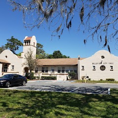
City of Belleview
Transit and Meeting Points
Useful pickup, handoff, or rendezvous points close to Belleview.
Ocala, Florida
The Villages-Lady Lake, FL
Wildwood, Florida
DeLand
Flight Path Map
This map shows the direct air route between Port Saint Lucie and Monticello. Straight-line distance: 309.48 mi (498.06 km).

#1 Port Saint Lucie
The second most populous city in St.
| Population | 209,715 |
| Coordinates | 27.2939300, -80.3503300 |
| Altitude | 5 |
| Country | United States |

#2 Monticello
City in Jefferson County, Florida, United States
| Population | 2,453 |
| Coordinates | 30.5451500, -83.8713000 |
| Altitude | 71 |
| Country | United States |
End: Monticello (-83.8713, 30.54515)
Estimated Travel Time
Distance: 567 km by road
| Speed | Time |
|---|---|
| 30 mph (48.3 km/h) | 11h 43m |
| 40 mph (64.37 km/h) | 08h 48m |
| 50 mph (80.47 km/h) | 07h 02m |
| 60 mph (96.56 km/h) | 05h 52m |
| 70 mph (112.65 km/h) | 05h 01m |
| 80 mph (129 km/h) | 04h 23m |
Fuel, Round Trip and CO2
Estimated fuel cost and emissions for this route.
| Fuel | $/gal | One way | Round trip |
|---|---|---|---|
| Regular gas | $4.15 | $51.52 | $103.04 |
| Mid-grade | $4.60 | $57.08 | $114.16 |
| Premium | $4.90 | $60.81 | $121.62 |
| Diesel | $4.35 | $54.03 | $108.05 |
Assumes 8.3 L/100 km (about 28.3 MPG). CO2 is an estimate and varies by vehicle, fuel blend, traffic, and terrain.
Prices in Florida · Jun 29, 2026
Distance to Other Cities
Planning a road trip? See the full trip guide on Trip.ovh — stops, fuel costs, weather, and departure timing.