Rancho Murieta, California
Rancho Murieta: census-designated place in Sacramento County, California
About
Rancho Murieta is a CDP located in the county of Sacramento in the U.S. state of California.

Quick Facts about Rancho Murieta
| Population | 5,488 |
| Country | United States of America |
| State | California (United States) |
| County | Sacramento County |
| Postal code | 95683 |
| Water as percent of area | 1.5% |
| Land as percent of area | 98.5% |
| Latitude & Longitude | 38.5019,-121.0947 |
| Altitude | 167 feet / 51 meters |
| Time Zone | Pacific Time Zone, UTC−08:00, UTC−07:00 |
| Local time | 05:52:39 (21st July 2026) |
| Weather | 64℉ Partly Cloudy 7-days weather |
Geography
Rancho Murieta is located at 38°30'7"N 121°5'41"W (38.5018500, -121.0946700).
Rancho Murieta map
Weather
Partly cloudy. Low around 64, with temperatures rising to around 66 overnight. South southeast wind around 3 mph.
7-Day ForecastWhere to Stay in Rancho Murieta
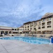
1The Murieta Inn and Spa
7337 Murieta Dr, Rancho Murieta, CA 95683, United States View details
Phone: +19163543900 | Website available
Nearby Schools and Colleges
Schools and campuses linked to Rancho Murieta, CA. Select a name to open its map and contact details.
| Code | Name | City | ZIP |
|---|---|---|---|
| 447953 | SUM Bible College and Theological Seminary | El Dorado Hills (CA) | 95762 |
| 444219 | Folsom Lake College | Folsom (CA) | 95630 |
| 489353 | Chamberlain University-California | Rancho Cordova (CA) | 95670 |
| 491880 | Independent Training & Apprenticeship Program | Sacramento (CA) | 95827-1741 |
| 457208 | InterCoast Colleges-Rancho Cordova | Rancho Cordova (CA) | 95827 |
Nearby Transit Stations (33)
Rail and bus stations connected to Rancho Murieta, CA. Select a station to open its map and address details.
| Code | Name | Address | Type |
|---|---|---|---|
| RSV | Roseville station | 201 Pacific Street | RAIL |
| RLN | Rocklin | Rocklin Rd. and Railroad Ave. | RAIL |
| EKG | Elk Grove, California | Harbor Point Drive at Renwick Avenue | BUS |
| SCS | Sacramento (State Capitol), California | 1389 10th Street | BUS |
| SAC | Sacramento Valley Station | 401 I Street | RAIL |
Closest post offices linked to Rancho Murieta.
| Post Office Name | City | ZIP |
|---|---|---|
| Sloughhou Post Office | Sloughhouse (CA) | 95683 |
| El Dorado Hill Post Office | El Dorado Hills (CA) | 95762 |
| Wilton Post Office | Wilton (CA) | 95693 |
| Rancho Cordova Post Office | Rancho Cordova (CA) | 95670 |
| Folsom Post Office | Folsom (CA) | 95630 |
Other cities in Sacramento County
Cities, towns, neighborhoods & other populated places in Sacramento County , CA. (more)
| City Name | Population | Title |
|---|---|---|
| Sacramento | 512,838 | The sixth most populous city in California and the center of the Sacramento metropolitan area. |
| Elk Grove | 177,302 | The third most populous city in Sacramento County, California. |
| Citrus Heights | 87,691 | A city in Sacramento County, California. |
| Folsom | 82,726 | A city in Sacramento County, California. |
| Rancho Cordova | 76,166 | A city in Sacramento County, California. |
| Carmichael | 61,762 | A city in Sacramento County, California. |
| Florin | 47,513 | A census-designated place in Sacramento County, California. |
| North Highlands | 42,694 | Census-designated place in Sacramento County, California |
| Orangevale | 33,960 | Census-designated place in Sacramento County, California |
| Foothill Farms | 33,121 | Census designated place |
| Fair Oaks | 30,912 | California |
| Galt | 26,551 | City in Sacramento County, California, United States of America |
| Rosemont | 22,681 | Village in the U. |
| Rio Linda | 15,106 | Census-designated place in Sacramento County, California |
| La Riviera | 10,802 | Census designated place |
| Live Oak | 9,048 | City in Sutter County, California, United States |
Distance to Other Cities
Rancho Murieta distances to largest California cities