Leeds, Alabama
Leeds: city in Jefferson, St.
About
Leeds is a city located in the county of Jefferson in the U.S. state of Alabama. Its population at the 2010 census was 11,773. After 10 years in 2020 city had an estimated population of 12,026 inhabitants.
The city was created 139 years ago in 1886.

Quick Facts about Leeds
| Population | 12,026 (2020) |
| Country | United States of America |
| State | Alabama (United States) |
| County | Jefferson County |
| Postal code | 35094 |
| Phone Area Codes | 205 |
| Water as percent of area | 0.95% |
| Land as percent of area | 99.05% |
| Latitude & Longitude | 33.5482,-86.5444 |
| Altitude | 627 feet / 191 meters |
| Establishment | January 01, 1887 (139 years ago) |
| Time Zone | Central Time Zone |
| Local time | 08:53:55 (3rd August 2026) |
| Population growth | 2.1% (2010-2020) |
| Weather | 85℉ Mostly Sunny then Chance Showers And Thunderstorms 7-days weather |
Geography
Leeds is located at 33°32'53"N 86°32'40"W (33.5481600, -86.5444300).
Leeds map
Weather
A chance of showers and thunderstorms after 1pm. Mostly sunny, with a high near 85. Northwest wind 0 to 5 mph. Chance of precipitation is 30%. New rai...
7-Day ForecastOfficial website of Leeds
Official WebsiteDemographics
The population of Leeds increased by 2.1% in 10 years.
| Year | Population | % Change | Method |
|---|---|---|---|
| 2010 | 11,773 | - | census |
| 2011 | 11,820 | 0.4% | estimation process |
| 2012 | 11,854 | 0.29% | estimation process |
| 2013 | 11,900 | 0.39% | estimation process |
| 2014 | 11,925 | 0.21% | estimation process |
| 2015 | 11,932 | 0.06% | estimation process |
| 2016 | 11,949 | 0.14% | estimation process |
| 2017 | 12,032 | 0.69% | estimation process |
| 2018 | 12,050 | 0.15% | estimation process |
| 2019 | 12,040 | -0.08% | estimation process |
| 2020 | 12,026 | -0.12% | estimation process |
Demographic Facts
| Estimated population as of July 1, 2019 : | 12,040 |
| Based on demographic estimates as of April 1, 2010 : | 11,772 |
| Based on demographic estimates as of 1 April 2010 : | 2.3% |
| April 1, 2020 Population : | 12,324 |
| April 1, 2010 Population : | 11,773 |
| People under 5 years old, percentage : | 6.0% |
| People under 18 years old, percentage : | 26.3% |
| People over 65 (%) : | 15.9% |
| Female persons, % : | 47.5% |
| White only, percent : | 78.8% |
| Black or African American alone, percent : | 18.5% |
| American Indian and Alaska Native only, % : | 0.7% |
| Asians alone % : | 0.1% |
| Only Native Hawaiians and Other Pacific Islanders, % : | 0.0% |
| % of people who have participated in two or more races : | 1.4% |
| % of Hispanic or Latino : | 3.8% |
| White people, not Hispanic or Latino people, make up the majority of the population. : | 76.0% |
| 2015-2019 Veterans : | 714 |
| Percentage of foreign-born people, 2015-2019 : | 3.4% |
| Rate of owner-occupied housing units, 2015-2019 : | 80.0% |
Economic Facts
| Rate of owner-occupied housing units, 2015-2019 : | 80.0% |
| Owner-occupied housing unit median value, 2015-2019 : | $160,500 |
| From 2015 to 2019, the median selected monthly owner costs - with a mortgage : | $1,173 |
| Monthly owner costs, without a mortgage, at the median, 2015-2019 : | $384 |
| 2015-2019 median gross rent : | $877 |
| 2015-2019 Households : | 4,792 |
| Population per household, 2015-2019 : | 2.63 |
| Living in the same house a year ago, percentage of people aged one year and up, 2015-2019 : | 90.9% |
| Languages other than English spoken at home, as a percentage of people aged 5 and up, 2015-2019 : | 4.3% |
| Households with computers, %, 2015-2019 : | 91.0% |
| Percentage of households with a broadband Internet subscription, 2015-2019 : | 79.0% |
| Percentage of people aged 25 and up with a high school diploma or higher, 2015-2019 : | 90.7% |
| Bachelor's degree or higher, proportion of people aged 25 and up, 2015-2019 : | 30.3% |
| Percentage of people under the age of 65 who have a disability, 2015-2019 : | 8.9% |
| Persons under the age of 65 who do not have health insurance, as a percentage : | 9.6% |
| Total civilian labor force, percent of population aged 16 and up, 2015-2019 : | 65.6% |
| Female labor force participation in the civilian labor force, as a percentage of the population aged 16 and up, 2015-2019 : | 57.5% |
| Total sales of lodging and food services in 2012 ($1,000) : | 25,322 |
| Total receipts/revenue for health care and social assistance in 2012 ($1,000) : | 8,258 |
| Manufacturers' total shipments in 2012 ($1,000) : | 335,409 |
| 2012 total retail sales ($1,000) : | 228,904 |
| 2012 total retail sales per capita : | $19,260 |
| Mean commute time to work (in minutes), workers aged 16 and up, 2015-2019 : | 25.1 |
| 2015-2019 median household income (in 2019 dollars) : | $60,863 |
| Income per capita in the previous 12 months (in 2019 dollars), 2015-2019 : | $31,726 |
| Percentage of people living in poverty : | 8.3% |
| Total number of businesses in 2012 : | 1,011 |
| Men-owned businesses in 2012 : | 484 |
| Women-owned businesses in 2012 : | 337 |
| Minority-owned businesses in 2012 : | 210 |
| Non-minority-owned businesses in 2012 : | 731 |
| Veteran-owned businesses in 2012 : | 117 |
| Nonveteran-owned businesses in 2012 : | 765 |
| 2010 population per square mile : | 514.9 |
| 2010 land area in square miles : | 22.86 |
Best Things to Do in Leeds
1Barber Vintage Motorsports Museum
6030 Barber Motorsports Pkwy, Leeds, AL 35094, United States View details
Phone: +12056997275 | Website available

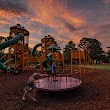
2Leeds Memorial Park
1159 Montevallo Rd SW, Leeds, AL 35094, United States View details
Phone: +12056992585
3The Livery
900-998 Thornton Ave NE, Leeds, AL 35094, United States View details
Phone: +12056996647 | Website available
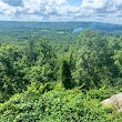
4Lookout
55530 AL-25, Leeds, AL 35094, United States View details
Where to Eat in Leeds
1The Backyard with Neighbors Brew & Pies and Saw's BBQ Leeds
6200 Grand River Blvd E Suite 510, Leeds, AL 35094, United States View details
Phone: +12053529180 | Website available

Where to Stay in Leeds
1Hampton Inn Birmingham/Leeds, AL
310 Rex Lake Rd, Leeds, AL 35094, United States View details
Phone: +12057024141 | Website available

Services and Civic Places in Leeds
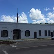
1Leeds City Hall
1400 9th St NE, Leeds, AL 35094 View details
Phone: +12056992585 | Website available
People born in Leeds (9)
People born in Leeds, including basketball player Charles Barkley, Marine Corps Medal of Honor recipient Alford L. McLaughlin, Major General in the United States Army Kenneth L. Farmer, Jr., .
More notable people
- William R. Lawley, Jr. (United States Air Force Medal of Honor recipient) he was born in 23/08/1920
- Chandler Champion (American beauty pageant winner)
- Harry Lee (Canadian football player) he was born in 27/01/1932
- Rebecca Bace (American computer security expert) she was born in 07/08/1955
- Dickie Drake (American politician) he was born in 02/04/1946
- Jonathan Rose (defensive back) he was born in 19/07/1993
Nearby Schools and Colleges
Schools and campuses linked to Leeds, AL. Select a name to open its map and contact details.
| Code | Name | City | ZIP |
|---|---|---|---|
| 450377 | Strayer University-Alabama | Birmingham (AL) | 35243 |
| 100663 | University of Alabama at Birmingham | Birmingham (AL) | 35294-0110 |
| 102049 | Samford University | Birmingham (AL) | 35229-2240 |
| 371034 | Alabama State College of Barber Styling | Gardendale (AL) | 35071 |
| 100937 | Birmingham-Southern College | Birmingham (AL) | 35254 |
Nearby Transit Stations (4)
Rail and bus stations connected to Leeds, AL. Select a station to open its map and address details.
| Code | Name | Address | Type |
|---|---|---|---|
| BHM | Birmingham | 1819 Morris Ave. | RAIL |
| ATN | Anniston | 126 West 4th St | RAIL |
| BRR | Brent, AL | 10393 Alabama Highway 5 | BUS |
| TCL | Tuscaloosa | 2105 Greensboro Ave | RAIL |
Closest post offices linked to Leeds.
| Post Office Name | City | ZIP |
|---|---|---|
| Leed Post Office | Leeds (AL) | 35094 |
Other places with the same name (4)
- Leeds, Maine town in Maine, United States with a population of 2,320 people.
- Leeds, Utah town in Washington County, Utah, United States with a population of 879 people.
- Leeds, Wisconsin town in Columbia County, Wisconsin, United States with a population of 781 people.
- Leeds, North Dakota city in North Dakota, United States with a population of 61 people.
Other cities in Jefferson County
Cities, towns, neighborhoods & other populated places in Jefferson County , AL. (more)
| City Name | Population | Title |
|---|---|---|
| Birmingham | 206,950 | The most populous city in Alabama. |
| Hoover | 85,959 | The most populous city in Jefferson County, Alabama. |
| Vestavia Hills | 34,317 | City in Jefferson and Shelby counties, Alabama, United States |
| Bessemer | 26,043 | City in Jefferson County, Alabama, United States |
| Homewood | 25,174 | City in Jefferson County, Alabama, United States |
| Trussville | 23,048 | City in Jefferson and St. |
| Mountain Brook | 20,413 | City in southeastern Jefferson County, Alabama |
| Center Point | 16,864 | City in Jefferson County, Alabama, United States |
| Hueytown | 15,202 | City in Jefferson County, Alabama, United States |
| Gardendale | 14,113 | City in Jefferson County, Alabama, United States |
| Irondale | 13,226 | Town in Alabama, United States |
| Pleasant Grove | 10,260 | City in western Jefferson County, Alabama |
| Forestdale | 10,162 | Unincorporated community in Alabama |
| Clay | 10,042 | City in Alabama, United States |
| Fultondale | 9,269 | City in Jefferson County, Alabama |
| Pinson | 7,060 | City in Jefferson County, Alabama, United States |
Distance to Other Cities
Leeds distances to largest Alabama cities