Jaipur, Rajasthan
Jaipur:
About
County Snapshot
Jaipur at a glance
Jaipur currently has 8 quality-checked populated place pages linked on MapSof, making it easier to jump from the county overview into local city pages.
Mapped populated places
8
These counts use a stricter populated-place filter so the main lists stay focused on real city and town pages.
Rajasthan counties
7
Open related pagesLargest city
JaipurPopulation 2,711,758
Top linked places
Quick Facts about Jaipur
| State | Rajasthan (India) |
| Latitude & Longitude | 27.0000,76.0000 |
| Time Zone | Asia/Kolkata |
| Local time | 10:22:34 (26th July 2026) |
Geography
Jaipur is located at 27°0'0"N 76°0'0"E (27.0000000, 76.0000000).
Jaipur map
Click "full screen"  icon to open full mode. View satellite images
Distretto di Jaipur, District de Jaipur, Districte de Jaipur, Distrito de Jaipur, Dzhajpur, JPR, Jaipur District, Jeipur, jaipur jilla, jayapura jil'ha, jayapura jila, jayapura jilla, jayapura jillo, jayapuramandalam, jeyppur mavattam, mntqt jaybwr, zhai pu er xian, Джайпур, جیپر ضلع, ضلع جے پور, منطقة جايبور, जयपुर जिला, जयपुर जिल्ला, जयपुरमण्डलम्, जयपूर जिल्हा, જયપુર જિલ્લો, ଜୟପୁର ଜିଲ୍ଲା, ஜெய்ப்பூர் மாவட்டம், జైపూర్ జిల్లా, ജയ്പൂർ ജില്ല, 齋浦爾縣
Map & Images (more maps)
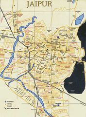
City Center Map Jaipur
738 x 1000
- 167,939k -
jpg
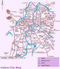
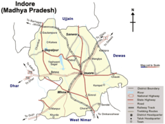
City Map of Indore
598 x 690
- 75,393k -
png
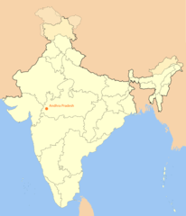
Location Map of Indore
1714 x 2000
- 107,620k -
png
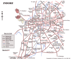
Map of Indore
750 x 623
- 91,449k -
png
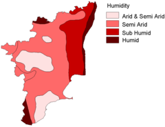
Relative Humidity Map Tamil Nadu
910 x 698
- 14,799k -
png
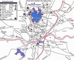
Tourist Map of Hyderabad
1200 x 981
- 179,618k -
jpg
Transport Map of Indore
700 x 525
- 45,505k -
png