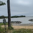
Shady Side, Maryland
Shady Side: census designated place
About
Shady Side is a CDP located in the county of Anne Arundel in the U.S. state of Maryland.

Quick Facts about Shady Side
| Population | 5,803 |
| Country | United States of America |
| State | Maryland (United States) |
| County | Anne Arundel County |
| Postal code | 20764 |
| Area | 20.74 km2 |
| Latitude & Longitude | 38.8418,-76.5122 |
| Altitude | 30 feet / 9 meters |
| Time Zone | America/New_York |
| Local time | 10:55:42 (24th July 2026) |
| Weather | 66℉ Clear 7-days weather |

Geography
Shady Side is located at 38°50'30"N 76°30'44"W (38.8417800, -76.5121800).
Shady Side map
Weather
Clear, with a low around 66. Southeast wind around 6 mph.
7-Day ForecastBest Things to Do in Shady Side
1Captain Avery Museum
1418 E West Shady Side Rd, Shady Side, MD 20764, United States View details
Phone: +14108674486 | Website available

2Jack Creek Park
1600 Snug Harbor Rd, Shady Side, MD 20764, United States View details
Phone: +14102227300 | Website available
3Franklin Point State Park
Shady Side, MD 20764, United States View details
Phone: +14109742149 | Website available

People born in Shady Side (1)
American horse trainer King T. Leatherbury was born in Shady Side
Nearby Schools and Colleges
Schools and campuses linked to Shady Side, MD. Select a name to open its map and contact details.
| Code | Name | City | ZIP |
|---|---|---|---|
| 163976 | St. John's College | Annapolis (MD) | 21401 |
Nearby Transit Stations (23)
Rail and bus stations connected to Shady Side, MD. Select a station to open its map and address details.
| Code | Name | Address | Type |
|---|---|---|---|
| KNT | Kent Island, MD | 3206 Main Street | BUS |
| NCR | New Carrollton station | 4300 Garden City Drive | RAIL |
| ESN | Easton Airport, Maryland | 29137 Newman Road | BUS |
| BWI | BWI Rail Station | 7 Amtrak Way | RAIL |
| WAS | Washington Union Station | 50 Massachusetts Ave NE | RAIL |
Closest post offices linked to Shady Side.
| Post Office Name | City | ZIP |
|---|---|---|
| Shady Sid Post Office | Shady Side (MD) | 20764 |
Other cities in Anne Arundel County
Cities, towns, neighborhoods & other populated places in Anne Arundel County , MD. (more)
| City Name | Population | Title |
|---|---|---|
| Glen Burnie | 67,639 | Census designated place in Maryland |
| Severn | 44,231 | Census-designated place in Anne Arundel County, Maryland, United States |
| Annapolis | 39,524 | City in and county seat of Anne Arundel County, Maryland, United States, and Maryland federated state capital city |
| Severna Park | 37,634 | Locale in Anne Arundel County, Maryland |
| Odenton | 37,132 | Census designated place |
| Crofton | 27,348 | Census place in Maryland, USA |
| Lake Shore | 19,477 | City in Cass County, Minnesota, United States of America |
| Green Haven | 19,326 | Neighborhood of Pasadena, Maryland, United States |
| Ferndale | 16,746 | Town in Anne Arundel County, Maryland, United States |
| Maryland City | 16,093 | Census designated place in Anne Arundel County, Maryland, United States |
| Parole | 15,922 | Provisional release from prison, with certain conditions such as probation in some states |
| Linthicum | 10,324 | Census designated place |
| Cape Saint Claire | 8,747 | Park in Anne Arundel County, Maryland, United States of America |
| Londontowne | 8,018 | Unincorporated area in Anne Arundel County, Maryland, United States |
| Jessup | 7,137 | Locality in Howard and Anne Arundel counties, Maryland, United States |
| Pumphrey | 5,322 | Census designated place |
Distance to Other Cities
Shady Side distances to largest Maryland cities