Quebec (Québec), CA
Quebec: province of Canada
About

State Snapshot
Québec at a glance
Québec currently has 124 quality-checked populated place pages and 1 county pages linked on MapSof.
Mapped cities & towns
124
These counts use a stricter populated-place filter so the main lists stay focused on real city and town pages.
County pages
1
Open related pagesLargest city
MontréalPopulation 1,801,546
Top linked places
Quick Facts about Québec
| Population | 8,484,965 |
| Country | Canada |
| Different from | Quebec City |
| Postal code | H, G, J |
| Area | 1542056 km2 |
| Official name | Québec, Quebec |
| Water as percent of area | 11.5% |
| Land as percent of area | 88.5% |
| Continent | North America |
| Easternmost point | Point(-57.108333333 51.5) |
| Northernmost point | Point(-77.508333333 62.581944444) |
| Latitude & Longitude | 52.0002,-71.9991 |
| Legislative body | Legislature of Quebec |
| Named for | Quebec City |
| Official language | French |
| Capital | Quebec City |
| Establishment | July 01, 1867 (159 years ago) |
| Time Zone | Eastern Time Zone |
| Local time | 15:18:17 (24th July 2026) |

Geography
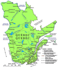
Québec is located at 52°0'1"N 71°59'57"W (52.000168346, -71.999072249). It has 9 neighbors: Maine, New Hampshire, New York, Vermont, New Brunswick, Northwest Territories, Nunavut, Ontario and Newfoundland and Labrador.
Quebec map
The largest city of Québec is Sherbrooke with a population of 169,136. Other cities include, Lévis population 147,440, Trois-Rivières population 138,134, Saint-Jean-sur-Richelieu population 98,036 and Saint-Jérôme population 78,839. See all Québec cities & populated places.
Largest Cities in Québec (more)
Cities, Towns, Villages, Neighborhoods & Other Populated Places in Québec.
| City Name | County | Population |
|---|---|---|
| Montréal | Kunoy | 1,801,546 |
| Québec | 528,595 | |
| Sherbrooke | Klaksvik | 169,136 |
| Lévis | Chaudière-Appalaches | 147,440 |
| Trois-Rivières | Hvannasund | 138,134 |
| Saint-Jean-sur-Richelieu | Montérégie | 98,036 |
| Brossard | Montérégie | 89,092 |
| Saint-Jérôme | Laurentides | 78,839 |
| Drummondville | Hvannasund | 78,345 |
| Granby | Montérégie | 68,599 |
| Saint-Hyacinthe | Montérégie | 56,886 |
| Shawinigan | Hvannasund | 49,571 |
| Victoriaville | Hvannasund | 47,516 |
| Rouyn-Noranda | Mačva | 43,011 |
| Salaberry-de-Valleyfield | Montérégie | 42,410 |
| Alma | Central Banat | 29,526 |
Show more Québec cities and populated places
Official website of Québec
Official Website- Kyōto Prefecture (2016 )
- Shanghai
- Laval
- Chaudière-Appalaches
- Lanaudière
- Laurentides
- Montreal Region
- Montérégie
- Mauricie
- Nord-du-Québec
- Outaouais
- Capitale-Nationale
- Bas-Saint-Laurent
- Abitibi-Témiscamingue
- Estrie
- Côte-Nord
- Saguenay–Lac-Saint-Jean
- Gaspésie–Îles-de-la-Madeleine
Demographics
| Year | Population | % Change | Method |
|---|---|---|---|
| 1851 | 890,261 | - | census |
| 1861 | 1,111,566 | 19.91% | census |
| 1871 | 1,191,516 | 6.71% | census |
| 1881 | 1,359,027 | 12.33% | census |
| 1891 | 1,488,535 | 8.7% | census |
| 1901 | 1,648,898 | 9.73% | census |
| 1911 | 2,005,776 | 17.79% | census |
| 1921 | 2,360,510 | 15.03% | census |
| 1931 | 2,874,662 | 17.89% | census |
| 1941 | 3,331,882 | 13.72% | census |
| 1951 | 4,055,681 | 17.85% | census |
| 1956 | 4,628,378 | 12.37% | census |
| 1961 | 5,259,211 | 11.99% | census |
| 1966 | 5,780,845 | 9.02% | census |
| 1971 | 6,027,764 | 4.1% | census |
| 1976 | 6,234,445 | 3.32% | census |
| 2011 | 7,903,001 | 21.11% | census |
| 2015 | 8,239,910 | 4.09% | population estimation |
| 2016 | 8,164,361 | -0.93% | census |
| 2017 | 8,425,996 | 3.11% | population estimation |
| 2019 | 8,484,965 | 0.69% | population estimation |
Other places with the same name (1)
- Québec, Quebec This Canadian city is located in the province of Québec, where it serves as the provincial capital. with a population of 528,595 people.
Québec Counties
Chaudière-Appalaches
administrative region in Quebec, Canada
| County Name | Population |
|---|---|
| Chaudière-Appalaches | 428,437 |
Show more Québec counties
Map & Images (more maps)
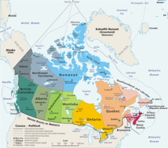
Map Canada Political 2
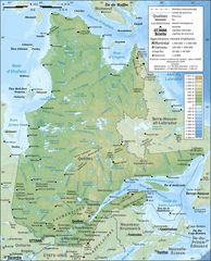
Quebec Province Topographic Map
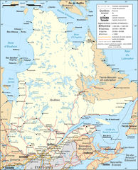
Quebec Province Transportation And Cities Map Fr