Prince Edward Island, Prince Edward Island
Prince Edward Island: province of Canada
About
State Snapshot
Prince Edward Island at a glance
Prince Edward Island currently has 7 quality-checked populated place pages and 0 county pages linked on MapSof.
Mapped cities & towns
7
These counts use a stricter populated-place filter so the main lists stay focused on real city and town pages.
County pages
0
Open related pagesLargest city
CharlottetownPopulation 36,094
Top linked places
Quick Facts about Prince Edward Island
| Population | 152,784 |
| Country | Canada |
| State | Prince Edward Island (Canada) |
| Different from | Prince Edward Island |
| Postal code | C |
| Area | 5620 km2 |
| Official name | Prince Edward Island, Île-du-Prince-Édouard |
| Has part | Prince Edward Island, list of islands of Prince Edward Island |
| Continent | North America |
| Easternmost point | Point(-61.966666666 46.45) |
| Northernmost point | Point(-63.99652 47.05843) |
| Latitude & Longitude | 46.5001,-62.9987 |
| Legislative body | General Assembly of Prince Edward Island |
| Named for | Prince Edward Island |
| Official language | English |
| Capital | Charlottetown |
| Time Zone | Atlantic Time Zone |
| Local time | 06:13:50 (10th June 2026) |
Geography
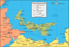
Prince Edward Island is located at 46°30'0"N 62°59'55"W (46.500112852, -62.998678816). It has 3 neighbors: New Brunswick, Nova Scotia and Canada.
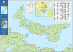
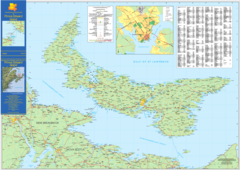
Prince Edward Island map
The largest city of Prince Edward Island is Summerside with a population of 14,808. . See all Prince Edward Island cities & populated places.
Largest Cities in Prince Edward Island
Cities, Towns, Villages, Neighborhoods & Other Populated Places in Prince Edward Island.
| City Name | County | Population |
|---|---|---|
| Charlottetown | 36,094 | |
| Summerside | 14,808 | |
| Cornwall | 2,272 | |
| Montague | 1,834 | |
| Kensington | 1,424 | |
| Souris | 1,284 | |
| Alberton | 1,147 |
Official website of Prince Edward Island
Official WebsiteDemographics
| Year | Population | % Change | Method |
|---|---|---|---|
| 1851 | 62,678 | - | census |
| 1861 | 80,857 | 22.48% | census |
| 1871 | 94,021 | 14% | census |
| 1881 | 108,891 | 13.66% | census |
| 1891 | 109,078 | 0.17% | census |
| 1901 | 103,259 | -5.64% | census |
| 1911 | 93,728 | -10.17% | census |
| 1921 | 88,615 | -5.77% | census |
| 1941 | 95,047 | 6.77% | census |
| 1951 | 98,429 | 3.44% | census |
| 1956 | 99,285 | 0.86% | census |
| 1961 | 104,629 | 5.11% | census |
| 1966 | 108,535 | 3.6% | census |
| 1971 | 111,641 | 2.78% | census |
| 1976 | 118,229 | 5.57% | census |
| 1981 | 122,506 | 3.49% | census |
| 1986 | 126,640 | 3.26% | census |
| 1991 | 129,765 | 2.41% | census |
| 1996 | 134,557 | 3.56% | census |
| 2001 | 135,294 | 0.54% | census |
| 2011 | 140,204 | 3.5% | census |
| 2015 | 88,038 | -59.25% | 1931-01-01T00:00:00Z |
| 2016 | 142,907 | 38.39% | census |
| 2017 | 152,784 | 6.46% | estimation process |
Prince Edward Island Counties
| County Name | Population |
|---|
Map & Images (more maps)
Prince Edward Island Map
Prince Edward Island Map 2