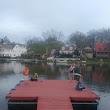
Lake Tapawingo, Missouri
Lake Tapawingo: City in Jackson County, Missouri, United States
About
Lake Tapawingo is a city located in the county of Jackson in the U.S. state of Missouri. Its population at the 2010 census was 730 and a population density of 567 people per km². After 10 years in 2020 city had an estimated population of 719 inhabitants.
Quick Facts about Lake Tapawingo
| Population | 719 (2020) |
| Country | United States of America |
| State | Missouri (United States) |
| County | Jackson County |
| Postal code | 64015 |
| Phone Area Codes | 816 |
| Area | 1.29 km2 |
| Latitude & Longitude | 39.0214,-94.3116 |
| Altitude | 850 feet / 259 meters |
| Time Zone | America/Chicago |
| Local time | 09:42:45 (24th July 2026) |
| Density | 559 Pop. per km² as of 2020 |
| Population growth | -1.53% (2010-2020) |
| Weather | 67℉ Chance Showers And Thunderstorms 7-days weather |
Geography
Lake Tapawingo is located at 39°1'17"N 94°18'42"W (39.0214000, -94.3116200).
Lake Tapawingo map
Weather
A chance of showers and thunderstorms before 4am, then showers and thunderstorms likely. Mostly cloudy, with a low around 67. East southeast wind arou...
7-Day ForecastDemographics
According to census records, the population of Lake Tapawingo decreased by 1.53% in 10 years.
| Year | Population | % Change | Method |
|---|---|---|---|
| 2010 | 730 | - | census |
| 2011 | 728 | -0.27% | estimation process |
| 2012 | 727 | -0.14% | estimation process |
| 2013 | 727 | 0% | estimation process |
| 2014 | 725 | -0.28% | estimation process |
| 2015 | 724 | -0.14% | estimation process |
| 2016 | 726 | 0.28% | estimation process |
| 2017 | 725 | -0.14% | estimation process |
| 2018 | 722 | -0.42% | estimation process |
| 2019 | 719 | -0.42% | estimation process |
| 2020 | 719 | 0% | estimation process |
Services and Civic Places in Lake Tapawingo
1City of Lake Tapawingo
144 Anchor Dr, Lake Tapawingo, MO 64015 View details
Phone: +18162293722 | Website available
Nearby Schools and Colleges
Schools and campuses linked to Lake Tapawingo, MO. Select a name to open its map and contact details.
| Code | Name | City | ZIP |
|---|---|---|---|
| 176716 | House of Heavilin Beauty College-Blue Springs | Blue Springs (MO) | 64014 |
Nearby Transit Stations (7)
Rail and bus stations connected to Lake Tapawingo, MO. Select a station to open its map and address details.
| Code | Name | Address | Type |
|---|---|---|---|
| IDP | Independence | 600 South Grand Ave. | RAIL |
| LEE | Lee's Summit | 217 SW Main St. | RAIL |
| KCY | Union Station | 30 West Pershing Rd. | RAIL |
| WAR | Warrensburg | 100 South Holden St. | RAIL |
| LRC | Lawrence | 413 East 7th Street | RAIL |
Closest post offices linked to Lake Tapawingo.
| Post Office Name | City | ZIP |
|---|---|---|
| Blue Spring Post Office | Blue Springs (MO) | 64014 |
Other cities in Jackson County
Cities, towns, neighborhoods & other populated places in Jackson County , MO. (more)
| City Name | Population | Title |
|---|---|---|
| Kansas City | 495,327 | The third most populous city in Missouri and the center of the Kansas City metropolitan area. |
| Independence | 116,774 | A city in Jackson County, Missouri. |
| East Independence | 110,675 | A census-designated place in Jackson County, Missouri. |
| Lee's Summit | 101,467 | The most populous city in Jackson County, Missouri. |
| Blue Springs | 56,547 | The most populous city in Jackson County, Missouri. |
| Raytown | 28,816 | City in Jackson County, Missouri, United States |
| Grandview | 24,711 | City in Washington, United States |
| Grain Valley | 14,827 | City in Jackson County, Missouri, United States |
| Oak Grove | 8,437 | City in Jackson County, Missouri, United States |
| Greenwood | 5,881 | Town in Jackson County, Florida in the United States |
| Sugar Creek | 3,235 | City in Missouri |
| Buckner | 3,010 | City in Jackson County, Missouri, United States |
| Marlborough | 2,142 | Village in St. |
| Lake Lotawana | 2,131 | City in Jackson County, Missouri, United States |
| Lone Jack | 1,378 | City in Jackson County, Missouri, United States |
| Adams | 690 | Town in Jackson County, Wisconsin, United States |