How far is Greer, SC from Simpsonville, SC?
Fastest route
The distance from Greer, South Carolina, to Simpsonville, South Carolina, is approximately 18.0 miles (29 kilometers). The fastest route to reach Simpsonville is via SC-14 E, I-85 S, I-385 S, and SC-417 S/NE Main St. The estimated travel time is 23 minutes.
Directions
- 🚗 Get on I-85 S: Head northwest on E Poinsett St toward S Main St, then turn left at the 1st cross street onto SC-14 E/S Main St. Continue to follow SC-14 E, and use the right lane to merge onto I-85 S via the ramp to Greenville.
- 🛣️ Continue on I-85 S: Stay on I-85 S and take Exit 51.
- 🚗 Merge onto I-385 S: Use the right 3 lanes to take exit 51 for I-385 S toward Columbia/Greenville. Keep left and merge onto I-385 S.
- 🔄 Continue on I-185 N: Keep right at the fork to continue on I-185 N.
- 🛣️ Take exit 31A for SC-417: Take exit 31A for SC-417 toward Laurens Rd/Simpsonville.
- 🚗 Follow SC-417 S/NE Main St: Follow SC-417 S/NE Main St to Hedge St in Simpsonville. Turn left onto SC-417 S/NE Main St and then left onto E College St.
Tips & Suggestions
- 🚦 Check Traffic Conditions: Before you start your journey, it's a good idea to check traffic conditions to ensure you take the fastest route.
- 🛣️ Plan for Potential Delays: While the estimated travel time is 23 minutes, unexpected delays might occur, so plan accordingly.
- ⛽ Fuel Up: Make sure your vehicle has enough fuel for the journey, especially if it's a long drive.
- 🚗 Maintain Speed Limit: Stick to the speed limits to ensure a safe and smooth trip.
- 📱 Use GPS Navigation: Utilize GPS or navigation apps to stay on track and avoid getting lost.
FAQs
Q: How long does it take to travel from Greer to Simpsonville? A: The estimated travel time is approximately 23 minutes.
Q: What is the distance between Greer and Simpsonville? A: The distance is approximately 18.0 miles (29 kilometers).
Q: Which route should I take to reach Simpsonville from Greer? A: The fastest route is via SC-14 E, I-85 S, I-385 S, and SC-417 S/NE Main St.
Q: Are there any potential traffic issues to be aware of? A: It's advisable to check traffic conditions before starting your journey to avoid potential delays.
Q: What should I do if I get lost during the drive? A: If you get lost, you can use GPS navigation apps to find your way back to the correct route.
Reverse, save, or send this route
This is an easy same-day return drive. Copy the route link, send it to another device, or print a clean version before you head out.
This is an easy same-day return drive.
Flight Distance
Driving Distance
Gas Cost Calculator
Leave and Arrive Planner
Pick a departure time to see your estimated arrival and same-day return window.
Drive time stays fixed at 00h 27m.
This is a short drive, so your comfort window is wide. Traffic and current weather matter more than the clock.
This departure sits inside the recommended comfort window for the route.
Halfway Point
A useful midpoint for breaks, coffee, or meeting in the middle.
Census-designated place in Greenville County, South Carolina
Route Weather Snapshot
Check the forecast at both ends before you head out.
Chance Rain Showers then Chance Showers And Thunderstorms
Slight Chance Rain Showers then Slight Chance Showers And Thunderstorms
Driving Route Map
The map below follows the saved road route between Greer and Simpsonville.
Turn-by-Turn Driving Directions
Step-by-step road directions between Greer and Simpsonville.
-
1
Start on East Poinsett Street
12 m · 7 sec · East Poinsett Street
-
2
Turn left onto South Main Street
1.3 mi · 3 min · South Main Street
-
3
Continue on South Highway 14
3.6 mi · 7 min · South Highway 14
-
4
Turn straight
9.4 mi · 16 min
-
5
Turn left onto Northeast Main Street
1.5 mi · 3 min · Northeast Main Street
-
6
Turn left onto East Curtis Street
114 m · 10 sec · East Curtis Street
-
7
Turn right onto Hedge Street
45 m · 7 sec · Hedge Street
-
8
Turn right
53 m · 18 sec
-
9
Turn left
33 m · 8 sec
-
10
Arrive at your destination
0 m · 1 sec
Car Route Details
A richer read on the saved driving route between Greer and Simpsonville.
Turn-heavy local drive
The route has frequent decision points for its length, so lane choice and turn timing will matter more than cruising speed.
Longest stretch
Turn straight
9.39 mi · 00h 16m
Route Summary
A quick read on whether this route feels easy, ambitious, or worth planning around.
A short regional drive
This route is short enough to handle as a quick errand, commute, or easy same-day return without much planning overhead.
Chance Rain Showers then Chance Showers And Thunderstorms leaving Greer and Slight Chance Rain Showers then Slight Chance Showers And Thunderstorms near Simpsonville.
Trip Questions
Direct answers travelers usually want before committing to the drive.
How long does it take to drive from Greer to Simpsonville?
The road trip is about 19 miles (30.6 km) and usually takes 00h 27m in normal driving conditions.
Is this a same-day trip or an overnight route?
This route is short enough to handle as a quick errand, commute, or easy same-day return without much planning overhead.
What is the halfway point on this route?
Five Forks is a useful midpoint, sitting about 8 miles from Greer and 11 miles from Simpsonville.
How much longer is the road route than the straight-line distance?
The direct path is about 14 miles (22.6 km), while the road route adds roughly 5 extra miles because roads do not follow the straight air line.
When is the best time to leave for this route?
A good departure window is usually 7:00 AM to 7:00 PM EDT. If you want a more comfortable same-day return, try to leave by 7:34 PM EDT.
How much will gas cost for this route?
Using about 28.3 MPG, regular gas is estimated at $2.65 one way or $5.31 round trip. Estimated CO2 is about 6 kg one way.
What should you check before leaving?
Before you leave, expect Chance Rain Showers then Chance Showers And Thunderstorms around Greer and Slight Chance Rain Showers then Slight Chance Showers And Thunderstorms near Simpsonville.
Stop Ideas Near Five Forks
Useful break, food, and waypoint ideas within about 15 miles of the route midpoint.
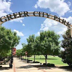
Greer City Park

City of Greer
Event Halls at Greer City Hall
Transit and Meeting Points
Useful pickup, handoff, or rendezvous points close to Five Forks.
Greenville
Spartanburg
Clemson
Toccoa
Flight Path Map
This map shows the direct air route between Greer and Simpsonville. Straight-line distance: 14.02 mi (22.56 km).

#1 Greer
City between Greenville and Spartanburg counties in the US state of South Carolina
| Population | 35,316 |
| Coordinates | 34.9387300, -82.2270600 |
| Altitude | 312 |
| Country | United States |

#2 Simpsonville
City in Greenville County, South Carolina, United States of America
| Population | 25,272 |
| Coordinates | 34.7370600, -82.2542800 |
| Altitude | 262 |
| Country | United States |
End: (-82.254452, 34.737223)
Estimated Travel Time
Distance: 31 km by road
| Speed | Time |
|---|---|
| 30 mph (48.3 km/h) | 00h 38m |
| 40 mph (64.37 km/h) | 00h 28m |
| 50 mph (80.47 km/h) | 00h 22m |
| 60 mph (96.56 km/h) | 00h 19m |
| 70 mph (112.65 km/h) | 00h 16m |
| 80 mph (129 km/h) | 00h 14m |
Fuel, Round Trip and CO2
Estimated fuel cost and emissions for this route.
| Fuel | $/gal | One way | Round trip |
|---|---|---|---|
| Regular gas | $3.96 | $2.65 | $5.31 |
| Mid-grade | $4.43 | $2.97 | $5.93 |
| Premium | $4.78 | $3.20 | $6.40 |
| Diesel | $5.62 | $3.77 | $7.54 |
Assumes 8.3 L/100 km (about 28.3 MPG). CO2 is an estimate and varies by vehicle, fuel blend, traffic, and terrain.
Prices in South Carolina · Jul 26, 2026
Distance to Other Cities
Planning a road trip? See the full trip guide on Trip.ovh — stops, fuel costs, weather, and departure timing.