How far is Greenville, SC from Woodruff, SC?
The driving distance from Greenville, SC to Woodruff, SC is about 25.8 miles (41.5 km), with a travel time of about 00h 45m by car.
- The straight-line flight distance is about 21.7 miles (34.9 km).
- For a round trip, plan for roughly 01h 31m of driving time before adding stops, traffic, or weather delays.
- A comfortable departure window is usually 8:00 AM to 10:00 AM EDT.
Reverse, save, or send this route
This route works well as a day trip with time at the destination. Copy the route link, send it to another device, or print a clean version before you head out.
This route works well as a day trip with time at the destination.
Flight Distance
Driving Distance
Gas Cost Calculator
Leave and Arrive Planner
Pick a departure time to see your estimated arrival and same-day return window.
Drive time stays fixed at 00h 45m.
A morning start gives you useful time at the destination and keeps the return out of the late evening.
You are leaving earlier than the recommended window, which gives you extra margin for breaks and traffic.
Halfway Point
A useful midpoint for breaks, coffee, or meeting in the middle.
Census-designated place in Greenville County, South Carolina
Route Weather Snapshot
Check the forecast at both ends before you head out.
Widespread Fog then Chance Showers And Thunderstorms
Widespread Fog then Slight Chance Showers And Thunderstorms
Driving Route Map
The map below follows the saved road route between Greenville and Woodruff.
Turn-by-Turn Driving Directions
Step-by-step road directions between Greenville and Woodruff.
-
1
Start on North Church Street
151 m · 21 sec · North Church Street
-
2
Turn left onto East North Street
2612 ft · 43 sec · East North Street
-
3
Continue straight
5.5 mi · 7 min
-
4
Take the exit slight right toward SC 146: Woodruff Road
1.3 km · 2 min
-
5
Keep slight right to continue on SC 146: Woodruff Road
891 ft · 22 sec
-
6
Keep slight left to continue on SC 146 East: Woodruff Road, Woodruff
58 m · 8 sec
-
7
Turn left onto Woodruff Road
4.6 mi · 8 min · Woodruff Road
-
8
Turn left onto South Bennetts Bridge Road
2.3 mi · 4 min · South Bennetts Bridge Road
-
9
Continue on Reidville Road
1.1 km · 1 min · Reidville Road
-
10
Turn sharp right onto Brockman McClimon Road
2.6 mi · 6 min · Brockman McClimon Road
-
11
At the end of the road, turn left onto Bragg Road
766 ft · 24 sec · Bragg Road
-
12
Turn right onto State Highway 417
69 m · 5 sec · State Highway 417
-
13
Enter the roundabout and take exit 2 toward State Highway 146
70 m · 5 sec · State Highway 146
-
14
Exit the roundabout onto State Highway 146
782 ft · 19 sec · State Highway 146
-
15
Continue on Highway 146
2.5 mi · 4 min · Highway 146
-
16
At the end of the road, turn right onto Highway 101
4.1 mi · 8 min · Highway 101
-
17
Continue on State Highway 101
1.1 km · 1 min · State Highway 101
-
18
At the end of the road, turn right onto North Main Street
1.6 km · 3 min · North Main Street
-
19
Arrive at your destination
0 m · 1 sec · South Main Street
Car Route Details
A richer read on the saved driving route between Greenville and Woodruff.
Turn-heavy local drive
The route has frequent decision points for its length, so lane choice and turn timing will matter more than cruising speed.
East North Street
Continue straight
5.46 mi · 00h 07m
Route Summary
A quick read on whether this route feels easy, ambitious, or worth planning around.
A comfortable day-trip route
This route works well as a day trip. You can leave in the morning, spend meaningful time at the destination, and still return the same day.
Widespread Fog then Chance Showers And Thunderstorms leaving Greenville and Widespread Fog then Slight Chance Showers And Thunderstorms near Woodruff.
Trip Questions
Direct answers travelers usually want before committing to the drive.
How long does it take to drive from Greenville to Woodruff?
The road trip is about 25.8 miles (41.5 km) and usually takes 00h 45m in normal driving conditions.
Is this a same-day trip or an overnight route?
This route works well as a day trip. You can leave in the morning, spend meaningful time at the destination, and still return the same day.
What is the halfway point on this route?
Five Forks is a useful midpoint, sitting about 12.9 miles from Greenville and 12.9 miles from Woodruff.
How much longer is the road route than the straight-line distance?
The direct path is about 21.7 miles (34.9 km), while the road route adds roughly 4.1 extra miles because roads do not follow the straight air line.
When is the best time to leave for this route?
A good departure window is usually 8:00 AM to 10:00 AM EDT. If you want a more comfortable same-day return, try to leave by 4:58 PM EDT.
How much will gas cost for this route?
Using about 28.3 MPG, regular gas is estimated at $3.60 one way or $7.21 round trip. Estimated CO2 is about 8.1 kg one way.
What should you check before leaving?
Before you leave, expect Widespread Fog then Chance Showers And Thunderstorms around Greenville and Widespread Fog then Slight Chance Showers And Thunderstorms near Woodruff.
Stop Ideas Near Five Forks
Useful break, food, and waypoint ideas within about 15 miles of the route midpoint.
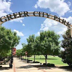
Greer City Park

City of Greer
Event Halls at Greer City Hall
Transit and Meeting Points
Useful pickup, handoff, or rendezvous points close to Five Forks.
Greenville
Spartanburg
Clemson
Toccoa
Flight Path Map
This map shows the direct air route between Greenville and Woodruff. Straight-line distance: 21.7 mi (34.93 km).

#1 Greenville
The most populous city in Greenville County, South Carolina.
| Population | 72,227 |
| Coordinates | 34.8526200, -82.3940100 |
| Altitude | 307 |
| Country | United States |

#2 Woodruff
City in Spartanburg County, South Carolina, United States
| Population | 4,507 |
| Coordinates | 34.7395700, -82.0370500 |
| Altitude | 240 |
| Country | United States |
End: Woodruff (-82.03705, 34.73957)
Estimated Travel Time
Distance: 42 km by road
| Speed | Time |
|---|---|
| 30 mph (48.3 km/h) | 00h 51m |
| 40 mph (64.37 km/h) | 00h 38m |
| 50 mph (80.47 km/h) | 00h 30m |
| 60 mph (96.56 km/h) | 00h 25m |
| 70 mph (112.65 km/h) | 00h 22m |
| 80 mph (129 km/h) | 00h 19m |
Fuel, Round Trip and CO2
Estimated fuel cost and emissions for this route.
| Fuel | $/gal | One way | Round trip |
|---|---|---|---|
| Regular gas | $3.96 | $3.60 | $7.21 |
| Mid-grade | $4.43 | $4.03 | $8.06 |
| Premium | $4.78 | $4.35 | $8.70 |
| Diesel | $5.62 | $5.12 | $10.24 |
Assumes 8.3 L/100 km (about 28.3 MPG). CO2 is an estimate and varies by vehicle, fuel blend, traffic, and terrain.
Prices in South Carolina · Jun 24, 2026
Distance to Other Cities
Planning a road trip? See the full trip guide on Trip.ovh — stops, fuel costs, weather, and departure timing.