How far is Friday Harbor, WA from Vancouver, WA?
The driving distance from Friday Harbor, WA to Vancouver, WA is about 267.6 miles (430.6 km), with a travel time of about 05h 23m by car.
- The straight-line flight distance is about 200.8 miles (323.1 km).
- For a round trip, plan for roughly 10h 46m of driving time before adding stops, traffic, or weather delays.
- A comfortable departure window is usually 6:00 AM to 8:00 AM PDT.
Reverse, save, or send this route
This drive is better planned with a longer stop or an overnight stay. Copy the route link, send it to another device, or print a clean version before you head out.
This drive is better planned with a longer stop or an overnight stay.
Flight Distance
Driving Distance
Gas Cost Calculator
Leave and Arrive Planner
Pick a departure time to see your estimated arrival and same-day return window.
Drive time stays fixed at 05h 23m.
An early departure helps you fit a real stop into the day without turning the return into a late-night drive.
You are leaving earlier than the recommended window, which gives you extra margin for breaks and traffic.
Halfway Point
A useful midpoint for breaks, coffee, or meeting in the middle.
The most populous city in Thurston County, Washington.
Route Weather Snapshot
Check the forecast at both ends before you head out.
Mostly Cloudy
Partly Cloudy
Driving Route Map
A saved road route is not available yet, so the map falls back to a straight-line overview.
Turn-by-Turn Driving Directions
Step-by-step road directions between Friday Harbor and Vancouver.
Route Summary
A quick read on whether this route feels easy, ambitious, or worth planning around.
A longer out-and-back drive
This is still possible in one day, but it becomes a long driving day. Leaving early and planning your stop window matters more here.
Mostly Cloudy leaving Friday Harbor and Partly Cloudy near Vancouver.
Trip Questions
Direct answers travelers usually want before committing to the drive.
How long does it take to drive from Friday Harbor to Vancouver?
The road trip is about 267.6 miles (430.6 km) and usually takes 05h 23m in normal driving conditions.
Is this a same-day trip or an overnight route?
This is still possible in one day, but it becomes a long driving day. Leaving early and planning your stop window matters more here.
What is the halfway point on this route?
Lacey is a useful midpoint, sitting about 100.4 miles from Friday Harbor and 167.1 miles from Vancouver.
How much longer is the road route than the straight-line distance?
The direct path is about 200.8 miles (323.1 km), while the road route adds roughly 66.8 extra miles because roads do not follow the straight air line.
When is the best time to leave for this route?
A good departure window is usually 6:00 AM to 8:00 AM PDT. If you want a more comfortable same-day return, try to leave by 6:14 AM PDT.
How much will gas cost for this route?
Using about 28.3 MPG, regular gas is estimated at $49.40 one way or $98.80 round trip. Estimated CO2 is about 83.9 kg one way.
What should you check before leaving?
Before you leave, expect Mostly Cloudy around Friday Harbor and Partly Cloudy near Vancouver.
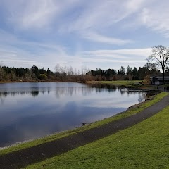
Stop Ideas Near Lacey
Useful break, food, and waypoint ideas within about 15 miles of the route midpoint.
City of Lacey - City Hall Parking
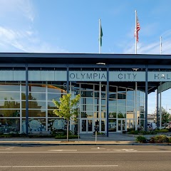
Olympia City Hall
Lacey Community Center
Steilacoom Town Of Firsts
Transit and Meeting Points
Useful pickup, handoff, or rendezvous points close to Lacey.
Centennial Station
Centralia station
Tacoma Dome Station
Tukwila station
Flight Path Map
This map shows the direct air route between Friday Harbor and Vancouver. Straight-line distance: 200.76 mi (323.09 km).

#1 Friday Harbor
Town in San Juan County, Washington, United States
| Population | 2,544 |
| Coordinates | 48.5342700, -123.0171200 |
| Altitude | 18 |
| Country | United States |

#2 Vancouver
The third most populous city in Washington.
| Population | 186,192 |
| Coordinates | 45.6387300, -122.6614900 |
| Altitude | 52 |
| Country | United States |
End: East Fourth Plain Boulevard (-122.661479, 45.638677)
Estimated Travel Time
Distance: 431 km by road
| Speed | Time |
|---|---|
| 30 mph (48.3 km/h) | 08h 54m |
| 40 mph (64.37 km/h) | 06h 41m |
| 50 mph (80.47 km/h) | 05h 21m |
| 60 mph (96.56 km/h) | 04h 27m |
| 70 mph (112.65 km/h) | 03h 49m |
| 80 mph (129 km/h) | 03h 20m |
Fuel, Round Trip and CO2
Estimated fuel cost and emissions for this route.
| Fuel | $/gal | One way | Round trip |
|---|---|---|---|
| Regular gas | $5.23 | $49.40 | $98.80 |
| Mid-grade | $5.57 | $52.55 | $105.10 |
| Premium | $5.77 | $54.48 | $108.96 |
| Diesel | $5.47 | $51.61 | $103.22 |
Assumes 8.3 L/100 km (about 28.3 MPG). CO2 is an estimate and varies by vehicle, fuel blend, traffic, and terrain.
Prices in Washington · Jul 17, 2026
Distance to Other Cities
Planning a road trip? See the full trip guide on Trip.ovh — stops, fuel costs, weather, and departure timing.