How far is Fort Lauderdale, FL from Greensboro, NC?
The driving distance from Fort Lauderdale, FL to Greensboro, NC is about 774.4 miles (1246.2 km), with a travel time of about 11h 53m by car.
- The straight-line flight distance is about 687.8 miles (1106.9 km).
- For a round trip, plan for roughly 23h 47m of driving time before adding stops, traffic, or weather delays.
- A comfortable departure window is usually 6:00 AM to 7:30 AM EDT.
Reverse, save, or send this route
This drive is better planned with a longer stop or an overnight stay. Copy the route link, send it to another device, or print a clean version before you head out.
This drive is better planned with a longer stop or an overnight stay.
Flight Distance
Driving Distance
Gas Cost Calculator
Leave and Arrive Planner
Pick a departure time to see your estimated arrival and same-day return window.
Drive time stays fixed at 11h 53m.
Starting early still helps, but most travelers will want a longer stop or an overnight stay on a route this long.
You are leaving earlier than the recommended window, which gives you extra margin for breaks and traffic.
Halfway Point
A useful midpoint for breaks, coffee, or meeting in the middle.
Census-designated place in Glynn County, Georgia
Route Weather Snapshot
Check the forecast at both ends before you head out.
Slight Chance Showers And Thunderstorms
Partly Cloudy
Driving Route Map
The map below follows the saved road route between Fort Lauderdale and Greensboro.
Turn-by-Turn Driving Directions
Step-by-step road directions between Fort Lauderdale and Greensboro.
-
1
Start on East Broward Boulevard
1 km · 1 min · East Broward Boulevard
-
2
Turn right onto Northwest 9th Avenue
2.9 mi · 5 min · Northwest 9th Avenue
-
3
Continue on Powerline Road
1.1 mi · 2 min · Powerline Road
-
4
Continue on South Powerline Road
2.4 mi · 5 min · South Powerline Road
-
5
Continue on South Pompano Parkway
1 mi · 2 min · South Pompano Parkway
-
6
Turn left onto West Atlantic Boulevard
2984 ft · 1 min · West Atlantic Boulevard
-
7
Turn right onto Northwest 31st Avenue
1.5 km · 2 min · Northwest 31st Avenue
-
8
Continue on Florida's Turnpike Toll, Miami, Orlando
610 ft · 17 sec
-
9
Keep slight right to continue on Orlando, Florida's Turnpike North
1761 ft · 43 sec
-
10
Merge slight left onto Florida's Turnpike
84.6 mi · 1 hr 33 min · Florida's Turnpike
-
11
Take the exit slight right toward FL 70: Fort Pierce, Vero Beach
2817 ft · 54 sec
-
12
Keep slight right to continue on FL 70 East: Fort Pierce
65 m · 5 sec
-
13
Merge slight left onto Okeechobee Road
1641 ft · 35 sec · Okeechobee Road
-
14
Take the exit slight right toward I 95
969 ft · 24 sec
-
15
Keep slight left to continue on I 95 North: Daytona Beach
2718 ft · 1 min
-
16
Merge slight left
203.6 mi · 3 hr 39 min
-
17
Take the exit slight right toward FL 9B: Jacksonville Beaches
1477 ft · 28 sec
-
18
Keep slight right to continue on FL 9B North: Jacksonville Beaches
2806 ft · 53 sec
-
19
Merge slight left
4.3 mi · 5 min
-
20
Merge slight right onto East Beltway
22.1 mi · 25 min · East Beltway
-
21
Take the exit slight right toward I 95: Jacksonville, Savannah
1.2 km · 2 min
-
22
Keep slight right to continue on I 95 North: International Airport, Savannah
1.3 km · 2 min
-
23
Merge slight left
117.8 mi · 2 hr 7 min
-
24
Keep slight left
177.8 mi · 3 hr 11 min
-
25
Take the exit slight right toward US 52: Florence, Darlington
813 ft · 28 sec
-
26
Keep slight right
616 ft · 15 sec
-
27
Merge slight left onto West Lucas Street
1.5 mi · 2 min · West Lucas Street
-
28
Continue on South Main Street
3.4 mi · 4 min · South Main Street
-
29
Continue on North Governor Williams Highway
16.3 mi · 19 min · North Governor Williams Highway
-
30
Continue on Main Street
2.1 mi · 3 min · Main Street
-
31
Turn left onto Cheraw Highway
12 mi · 17 min · Cheraw Highway
-
32
Turn right
2.6 mi · 3 min
-
33
Turn right onto Church Street
663 ft · 9 sec · Church Street
-
34
Continue on Front Street
2788 ft · 42 sec · Front Street
-
35
Turn right
1.8 mi · 2 min
-
36
Turn left
17.3 mi · 24 min
-
37
Turn straight
4.4 mi · 6 min
-
38
Continue straight
2369 ft · 37 sec
-
39
Keep slight right to continue on I 73 North, I 74 West, US 220 North: Asheboro
57.8 mi · 1 hr 5 min
-
40
Keep slight left to continue on I 73 North, US 220 North: Greensboro
17.6 mi · 20 min
-
41
Continue on Freeman Mill Road
2.4 mi · 3 min · Freeman Mill Road
-
42
Turn straight onto Freeman Mill Road
3150 ft · 53 sec · Freeman Mill Road
-
43
Continue on South Edgeworth Street
1261 ft · 27 sec · South Edgeworth Street
-
44
Turn right onto West Market Street
1233 ft · 40 sec · West Market Street
-
45
Arrive at your destination
0 m · 1 sec · West Market Street
Car Route Details
A richer read on the saved driving route between Fort Lauderdale and Greensboro.
Long-distance drive
This route is long enough that fuel, rest stops, weather, and timing matter more than any single maneuver.
I 95 North
Merge slight left
204 mi · 03h 39m
Route Summary
A quick read on whether this route feels easy, ambitious, or worth planning around.
Better with a longer stop
This route is long enough that most travelers will be better off planning an overnight stay or a more deliberate stop window.
Slight Chance Showers And Thunderstorms leaving Fort Lauderdale and Partly Cloudy near Greensboro.
Trip Questions
Direct answers travelers usually want before committing to the drive.
How long does it take to drive from Fort Lauderdale to Greensboro?
The road trip is about 774.4 miles (1246.2 km) and usually takes 11h 53m in normal driving conditions.
Is this a same-day trip or an overnight route?
This route is long enough that most travelers will be better off planning an overnight stay or a more deliberate stop window.
What is the halfway point on this route?
Dock Junction is a useful midpoint, sitting about 383.7 miles from Fort Lauderdale and 390.7 miles from Greensboro.
How much longer is the road route than the straight-line distance?
The direct path is about 687.8 miles (1106.9 km), while the road route adds roughly 86.6 extra miles because roads do not follow the straight air line.
When is the best time to leave for this route?
A good departure window is usually 6:00 AM to 7:30 AM EDT. Starting early still helps, but most travelers will want a longer stop or an overnight stay on a route this long.
How much will gas cost for this route?
Using about 28.3 MPG, regular gas is estimated at $113.32 one way or $226.65 round trip. Estimated CO2 is about 242.8 kg one way.
What should you check before leaving?
Before you leave, expect Slight Chance Showers And Thunderstorms around Fort Lauderdale and Partly Cloudy near Greensboro.
Stop Ideas Near Dock Junction
Useful break, food, and waypoint ideas within about 15 miles of the route midpoint.

Historic Brunswick Courthouse
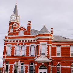
Brunswick Old City Hall

Brunswick Housing Authority
Transit and Meeting Points
Useful pickup, handoff, or rendezvous points close to Dock Junction.
Jesup
Jacksonville
Savannah
Flight Path Map
This map shows the direct air route between Fort Lauderdale and Greensboro. Straight-line distance: 687.81 mi (1106.93 km).

#1 Fort Lauderdale
The second most populous city in Broward County, Florida.
| Population | 184,245 |
| Coordinates | 26.1223100, -80.1433800 |
| Altitude | 1 |
| Country | United States |

#2 Greensboro
The third most populous city in North Carolina and the center of the Greensboro metropolitan area.
| Population | 297,878 |
| Coordinates | 36.0726400, -79.7919800 |
| Altitude | 266 |
| Country | United States |
End: West Market Street (-79.791986, 36.072568)
Estimated Travel Time
Distance: 1246 km by road
| Speed | Time |
|---|---|
| 30 mph (48.3 km/h) | 25h 48m |
| 40 mph (64.37 km/h) | 19h 21m |
| 50 mph (80.47 km/h) | 15h 29m |
| 60 mph (96.56 km/h) | 12h 54m |
| 70 mph (112.65 km/h) | 11h 03m |
| 80 mph (129 km/h) | 09h 39m |
Fuel, Round Trip and CO2
Estimated fuel cost and emissions for this route.
| Fuel | $/gal | One way | Round trip |
|---|---|---|---|
| Regular gas | $4.15 | $113.32 | $226.65 |
| Mid-grade | $4.60 | $125.56 | $251.13 |
| Premium | $4.90 | $133.76 | $267.52 |
| Diesel | $4.35 | $118.84 | $237.68 |
Assumes 8.3 L/100 km (about 28.3 MPG). CO2 is an estimate and varies by vehicle, fuel blend, traffic, and terrain.
Prices in Florida · Jul 19, 2026
Distance to Other Cities
Planning a road trip? See the full trip guide on Trip.ovh — stops, fuel costs, weather, and departure timing.