Burtonsville, Maryland
Burtonsville: census-designated place in Montgomery County, Maryland, United States
About
Burtonsville is a CDP located in the county of Montgomery in the U.S. state of Maryland.

Quick Facts about Burtonsville
| Population | 8,323 |
| Country | United States of America |
| State | Maryland (United States) |
| County | Montgomery County |
| Postal code | 20866 |
| Area | 21.27 km2 |
| Latitude & Longitude | 39.1112,-76.9325 |
| Altitude | 489 feet / 149 meters |
| Time Zone | Eastern Time Zone |
| Local time | 07:24:06 (18th July 2026) |
| Weather | 73℉ Smoke 7-days weather |

Geography
Burtonsville is located at 39°6'40"N 76°55'57"W (39.1112200, -76.9324800).
Burtonsville map
Weather
Smoke before 2am, then smoke and a slight chance of showers and thunderstorms. Mostly cloudy, with a low around 73. Southeast wind around 3 mph. Chanc...
7-Day ForecastBest Things to Do in Burtonsville
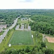
1Fairland Recreational Park
3928 Greencastle Rd, Burtonsville, MD 20866, United States View details
Phone: +13017746255 | Website available
2Washington Kali Temple
16126 New Columbia Pike, Burtonsville, MD 20866, United States View details
Phone: +13014768152 | Website available

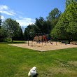
3Burtonsville Local Park
Burtonsville, MD 20866, United States View details
Phone: +13014952595 | Website available
4Columbia Local Park
14900 Old Columbia Pike, Burtonsville, MD 20866, United States View details
Phone: +13014952595 | Website available

5McKnew Local Park
14901 Saddle Creek Dr, Burtonsville, MD 20866, United States View details
Phone: +13014952595 | Website available

People born in Burtonsville (1)
Secretary of State of Maryland (1927-2010) Tyras S. Athey was born in Burtonsville
Nearby Schools and Colleges
Schools and campuses linked to Burtonsville, MD. Select a name to open its map and contact details.
| Code | Name | City | ZIP |
|---|---|---|---|
| 164085 | Maryland University of Integrative Health | Laurel (MD) | 20723 |
| 162061 | Capitol Technology University | Laurel (MD) | 20708 |
| 480994 | Aspen Beauty Academy of Laurel | Laurel (MD) | 20724 |
Nearby Transit Stations (26)
Rail and bus stations connected to Burtonsville, MD. Select a station to open its map and address details.
| Code | Name | Address | Type |
|---|---|---|---|
| RKV | Rockville station | 251 Hungerford Drive at Park Rd. | RAIL |
| NCR | New Carrollton station | 4300 Garden City Drive | RAIL |
| BWI | BWI Rail Station | 7 Amtrak Way | RAIL |
| WAS | Washington Union Station | 50 Massachusetts Ave NE | RAIL |
| BAL | Pennsylvania Station | 1515 North Charles Street | RAIL |
Closest post offices linked to Burtonsville.
| Post Office Name | City | ZIP |
|---|---|---|
| Burtonsvill Post Office | Burtonsville (MD) | 20866 |
Other cities in Montgomery County
Cities, towns, neighborhoods & other populated places in Montgomery County , MD. (more)
| City Name | Population | Title |
|---|---|---|
| Germantown | 86,395 | Census-designated place in Montgomery County, Maryland, United States |
| Silver Spring | 71,452 | A city in Montgomery County, Maryland. |
| Rockville | 69,512 | The most populous city in Montgomery County, Maryland. |
| Gaithersburg | 67,741 | The second most populous city in Montgomery County, Maryland. |
| Bethesda | 62,448 | A census-designated place (CDP) in Montgomery County, Maryland. |
| Aspen Hill | 48,759 | Census-designated place in Montgomery County, Maryland, United States |
| Potomac | 44,965 | Census-designated place in Montgomery County, Maryland, United States |
| North Bethesda | 43,828 | A census-designated place in Montgomery County, Maryland. |
| Olney | 33,844 | Unincorporated area of Montgomery County, Maryland, United States of America |
| Montgomery Village | 32,032 | Unincorporated community in Montgomery County, Maryland, United States |
| North Potomac | 24,410 | Census-designated place in Montgomery County, Maryland, United States |
| Fairland | 23,681 | Town in Oklahoma, United States |
| White Oak | 19,020 | Unincorporated area in Montgomery County, Maryland, United States |
| Takoma Park | 17,696 | City in Maryland, United States |
| Cloverly | 15,126 | Community in Montgomery County, Maryland, United States |
| Colesville | 14,647 | Unincorporated area in Montgomery County, Maryland, United States |
Distance to Other Cities
Burtonsville distances to largest Maryland cities