Yorktown Heights, New York
Yorktown Heights: CDP in Westchester County, New York
About
Yorktown Heights is a city located in the county of Westchester in the U.S. state of New York.

Quick Facts about Yorktown Heights
| Population | 1,781 |
| Country | United States of America |
| State | New York (United States) |
| County | Westchester County |
| Postal code | 10598 |
| Area | 2.38 km2 |
| Latitude & Longitude | 41.2709,-73.7776 |
| Altitude | 492 feet / 150 meters |
| Time Zone | America/New_York |
| Local time | 04:19:10 (18th July 2026) |
| Weather | 80℉ Areas Of Smoke then Smoke 7-days weather |

Geography
Yorktown Heights is located at 41°16'15"N 73°46'39"W (41.2709300, -73.7776300).
Yorktown Heights map
Weather
Areas of smoke before 8am, then areas of smoke and a slight chance of rain showers between 8am and 11am, then areas of smoke and showers and thunderst...
7-Day ForecastOfficial website of Yorktown Heights
Official WebsiteServices and Civic Places in Yorktown Heights
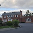
1Yorktown Town Hall
363 Underhill Ave, Yorktown Heights, NY 10598 View details
Phone: +19149625722 | Website available
People born in Yorktown Heights (6)
People born in Yorktown Heights, including mathematician Edward Burger, writer Maryanne Vollers, diplomat Paul W. Jones, .
More notable people
- Rebekah Mercer (American lobbyist and Republican donor) she was born in 01/12/1973
- Toriana Patterson (American association football player (1994-)) she was born in 02/02/1994
- Jonathan de Marte (American baseball player) he was born in 29/04/1993
Nearby Schools and Colleges
Schools and campuses linked to Yorktown Heights, NY. Select a name to open its map and contact details.
| Code | Name | City | ZIP |
|---|---|---|---|
| 197674 | Yeshiva of Nitra Rabbinical College | Mount Kisco (NY) | 10549 |
| 192165 | Kehilath Yakov Rabbinical Seminary | Ossining (NY) | 10562 |
| 460552 | Finger Lakes School of Massage | Mt. Kisco (NY) | 10549 |
| 194189 | Ohr Hameir Theological Seminary | Peekskill (NY) | 10566 |
| 193991 | Empire Beauty School-Peekskill | Peekskill (NY) | 10566 |
Nearby Transit Stations (21)
Rail and bus stations connected to Yorktown Heights, NY. Select a station to open its map and address details.
| Code | Name | Address | Type |
|---|---|---|---|
| CRT | Croton–Harmon station | 1 Croton Point Avenue | RAIL |
| STM | Stamford Transportation Center | Washington Blvd and South State St. | RAIL |
| YNY | Yonkers station | 5 Buena Vista Ave. | RAIL |
| NRO | New Rochelle station | 1 Railroad Plaza | RAIL |
| BRP | Bridgeport | 525 Water St. | RAIL |
Other cities in Westchester County
Cities, towns, neighborhoods & other populated places in Westchester County , NY. (more)
| City Name | Population | Title |
|---|---|---|
| Yonkers | 200,040 | The second most populous city in Westchester County, New York. |
| Greenburgh | 90,543 | Town |
| New Rochelle | 80,973 | A city in Westchester County, New York. |
| Mount Vernon | 68,628 | The most populous city in Westchester County, New York. |
| White Plains | 58,286 | The most populous city in Westchester County, New York. |
| Rye | 46,100 | A town in Westchester County, New York. |
| Ossining | 37,551 | Town in Westchester County, New York, United States |
| Yorktown | 35,988 | Town in New York |
| Spring Valley | 32,258 | Village in New York, United States |
| Mamaroneck | 29,343 | Town in Westchester County, New York |
| Harrison | 28,959 | Community (coterminous town-village) in Westchester County, New York |
| Port Chester | 28,857 | Village in Westchester County, New York |
| Peekskill | 24,087 | City in Westchester County, New York, United States |
| Somers | 21,476 | Town in New York, US |
| Scarsdale | 17,785 | Town and village in Westchester County, New York, United States |
| Bedford | 17,450 | Town in Westchester County, New York, United States |
Distance to Other Cities
Yorktown Heights distances to largest New York cities