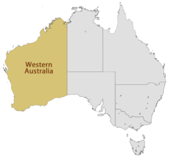
State of Western Australia, Western Australia
State of Western Australia: state of Australia
About

State Snapshot
State of Western Australia at a glance
State of Western Australia currently has 45 quality-checked populated place pages and 58 county pages linked on MapSof.
Mapped cities & towns
45
These counts use a stricter populated-place filter so the main lists stay focused on real city and town pages.
County pages
58
Open related pagesLargest city
PerthPopulation 2,059,484
Top linked places
Quick Facts about State of Western Australia
| Population | 0 |
| Country | Australia |
| State | Western Australia (Australia) |
| Phone Area Codes | 08 |
| Area | 2527013 km2 |
| Latitude & Longitude | -25.0000,122.0000 |
| Legislative body | Parliament of Western Australia |
| Named for | west, Australia |
| Altitude | 1,759 feet / 536 meters |
| Capital | Perth |
| Establishment | January 01, 1829 (197 years ago) |
| Time Zone | UTC+08:00 |
| Local time | 08:52:05 (23rd July 2026) |
Geography
State of Western Australia is located at 25°0'0"S 122°0'0"E (-25.0000000, 122.0000000).
State of Western Australia map
The largest city of State of Western Australia is Mandurah with a population of 83,294. Other cities include, Geraldton population 26,872, Busselton population 21,898 and Kalgoorlie population 4,189. See all State of Western Australia cities & populated places.
Largest Cities in State of Western Australia (more)
Cities, Towns, Villages, Neighborhoods & Other Populated Places in State of Western Australia.
| City Name | County | Population |
|---|---|---|
| Perth | City of Perth | 2,059,484 |
| Rockingham | Rockingham | 108,022 |
| Mandurah | Mandurah | 83,294 |
| Bunbury | Bunbury | 68,248 |
| Kwinana | Kwinana | 38,918 |
| Albany | Albany | 33,650 |
| Geraldton | Greater Geraldton | 26,872 |
| Busselton | Busselton | 21,898 |
| Newman | East Pilbara | 12,316 |
| Maylands | Bayswater | 12,101 |
| Karratha | Karratha | 11,728 |
| Joondalup | Joondalup | 9,302 |
| Mosman Park | Mosman Park | 8,566 |
| Quinns Rocks | Wanneroo | 8,442 |
| Bentley | Canning | 8,323 |
| West Busselton | Busselton | 8,072 |
Show more State of Western Australia cities and populated places
Official website of State of Western Australia
Official Website- Shire of Corrigin
- Town of Claremont
- Shire of Lake Grace
- Shire of Northam
- Shire of Wickepin
- Shire of Victoria Plains
- Shire of Capel
- Town of Cottesloe
- Town of Bassendean
- Shire of Kojonup
- Shire of Nannup
- City of Karratha
- Shire of Three Springs
- Shire of Bruce Rock
- Shire of Derby-West Kimberley
- Shire of Merredin
- City of Swan
- Shire of Shark Bay
- City of Fremantle
- City of Bunbury
- City of Bayswater
- Shire of Williams
- City of Belmont
- Shire of Quairading
- Shire of Irwin
- Shire of Mundaring
- Shire of Collie
- Town of Narrogin
- Shire of Jerramungup
- Shire of Leonora
- City of Kalamunda
- Shire of Augusta-Margaret River
- Shire of Cunderdin
- Shire of Westonia
- Shire of East Pilbara
- Shire of Koorda
- Shire of Broome
- Shire of Kellerberrin
- Shire of Mount Marshall
- Shire of Ngaanyatjarraku
- Shire of Peppermint Grove
- Shire of Nungarin
- Shire of Tammin
- Shire of Dumbleyung
- Shire of Wandering
- City of Melville
- Shire of Cranbrook
- Shire of Donnybrook-Balingup
- Shire of Dandaragan
- City of Joondalup
- Shire of Esperance
- Shire of Pingelly
- Shire of Perenjori
- Shire of Menzies
- Shire of Wiluna
- Shire of Katanning
- Shire of Coolgardie
- Shire of Broomehill-Tambellup
- Shire of Murchison
- Shire of Coorow
- Shire of Exmouth
- Shire of Sandstone
- Shire of Morawa
- City of South Perth
- City of Cockburn
- Shire of Chapman Valley
- City of Subiaco
- Shire of Beverley
- Shire of York
- Shire of Dardanup
- City of Stirling
- Shire of Narrogin
- Shire of Woodanilling
- Shire of Kondinin
- Shire of Kulin
- Shire of Mingenew
- Shire of Halls Creek
- Shire of Goomalling
- Shire of Ashburton
- Shire of Murray
- Shire of Gnowangerup
- City of Perth
- Shire of Trayning
- City of Gosnells
- Shire of Dowerin
- City of Nedlands
- Shire of Wyalkatchem
- Town of Victoria Park
- Shire of Wyndham-East Kimberley
- Shire of Carnamah
- Shire of Wagin
- City of Busselton
- City of Kwinana
- City of Geraldton-Greenough
- Shire of Mullewa
- City of Vincent
- City of Greater Geraldton
- Shire of Northampton
- Shire of West Arthur
- Town of Port Hedland
- City of Mandurah
- Shire of Bridgetown-Greenbushes
- Shire of Yilgarn
- Shire of Chittering
- City of Kalgoorlie-Boulder
- Shire of Meekatharra
- Town of Cambridge
- City of Rockingham
- Shire of Yalgoo
- Shire of Boddington
- Shire of Dundas
- Shire of Boyup Brook
- Town of East Fremantle
- Shire of Denmark
- Shire of Carnarvon
- Shire of Ravensthorpe
- Shire of Mukinbudin
- Shire of Gingin
- Shire of Kent
- Shire of Wongan-Ballidu
- Shire of Serpentine-Jarrahdale
- Shire of Dalwallinu
- Shire of Mount Magnet
- City of Armadale
- City of Canning
- Shire of Narembeen
- Shire of Harvey
- Shire of Brookton
- City of Albany
- Shire of Cue
- Shire of Manjimup
- Shire of Upper Gascoyne
- Shire of Laverton
- Shire of Cuballing
- Shire of Plantagenet
- Shire of Moora
- City of Wanneroo
- Shire of Toodyay
- Shire of Waroona
- Town of Mosman Park
Demographics
| Year | Population | % Change | Method |
|---|---|---|---|
| 2014 | 2,565,600 | - | |
| 2026 | 27,536,874 | 90.68% |
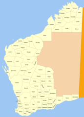
State of Western Australia Counties
| County Name | Population |
|---|
Show more State of Western Australia counties
Map & Images (more maps)
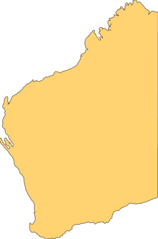
Blank Map of Western Australia
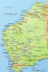
Cities Map of Western Australia
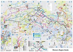
Detailed Map of Western Australia
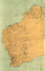
Historical Map of Western Australia
Location Map of Western Australia
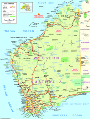
Map of Western Australia