Shelburne Falls, Massachusetts
Shelburne Falls: Census-designated place in Franklin County, Massachusetts
About
Shelburne Falls is a CDP located in the county of Franklin in the U.S. state of Massachusetts.
Quick Facts about Shelburne Falls
| Population | 1,731 |
| Country | United States of America |
| State | Massachusetts (United States) |
| County | Franklin County |
| Different from | Shelburne |
| Postal code | 01370 |
| Area | 6.78 km2 |
| Latitude & Longitude | 42.6043,-72.7393 |
| Altitude | 404 feet / 123 meters |
| Time Zone | America/New_York |
| Local time | 09:35:40 (10th July 2026) |
| Weather | 68℉ Mostly Clear 7-days weather |

Geography
Shelburne Falls is located at 42°36'15"N 72°44'21"W (42.6042500, -72.7392600).
Shelburne Falls map
Weather
Mostly clear, with a low around 68. Northwest wind around 5 mph.
7-Day ForecastServices and Civic Places in Shelburne Falls
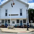
1Buckland Town Hall
17 State St, Shelburne Falls, MA 01370 View details
Phone: +14136256330 | Website available
People born in Shelburne Falls (6)
People born in Shelburne Falls, including singer-songwriter, pianist, and guitarist Seth Glier, politician Epaphroditus Ransom, author, attorney, and activist Scott Lively, .
More notable people
- C. L. Upton (American football coach) he was born in 10/09/1870
- Gary LaPierre (American journalist) he was born in 14/04/1942
- Jim Andrews (American baseball player) he was born in 05/06/1865
Nearby Schools and Colleges
Schools and campuses linked to Shelburne Falls, MA. Select a name to open its map and contact details.
| Code | Name | City | ZIP |
|---|---|---|---|
| 165981 | Greenfield Community College | Greenfield (MA) | 01301-9739 |
Nearby Transit Stations (30)
Rail and bus stations connected to Shelburne Falls, MA. Select a station to open its map and address details.
| Code | Name | Address | Type |
|---|---|---|---|
| GFD | John W. Olver Transit Center | 12 Olive Street | RAIL |
| BRA | Union Station | 10 Vernon Rd | RAIL |
| AMM | Amherst, Massachusetts | 13 Railroad St. | RAIL |
| NHT | Union Station | 170 Pleasant Street | RAIL |
| PIT | Joseph Scelsi Intermodal Transportation Center | 1 Columbus Avenue | RAIL |
Closest post offices linked to Shelburne Falls.
| Post Office Name | City | ZIP |
|---|---|---|
| Shelburne Fall Post Office | Shelburne Falls (MA) | 01370 |
Other cities in Franklin County
Cities, towns, neighborhoods & other populated places in Franklin County , MA. (more)
| City Name | Population | Title |
|---|---|---|
| Greenfield | 17,241 | City in Massachusetts, United States; county seat of Franklin County |
| Montague | 8,203 | Town in Massachusetts, United States |
| Orange | 7,581 | Town in Franklin County, Massachusetts, United States |
| Deerfield | 5,049 | Town in Massachusetts |
| Turners Falls | 4,470 | Census-designated place in Franklin County, Massachusetts |
| Sunderland | 3,634 | Town in Massachusetts |
| Northfield | 2,958 | Town in Franklin County, Massachusetts, United States |
| Bernardston | 2,089 | City in Franklin County, Massachusetts, United States of America |
| South Deerfield | 1,880 | Census-designated place in Franklin County, Massachusetts |
| Conway | 1,875 | Town in Franklin County, Massachusetts, USA |
| Buckland | 1,851 | City in Alaska, USA |
| Shelburne | 1,840 | Human settlement in Franklin County, Massachusetts, United States of America |
| Leverett | 1,836 | Town in Franklin County, Massachusetts, United States |
| Shutesbury | 1,753 | Town in Massachusetts |
| Erving | 1,749 | Town of the United States |
| Ashfield | 1,720 | Town in Massachusetts, United States |
Distance to Other Cities
Shelburne Falls distances to largest Massachusetts cities