Sendai, Miyagi
Sendai: This major city in Japan's Miyagi Prefecture is located on the Pacific coast of Honshu.
About
Quick Facts about Sendai
| Population | 1,058,070 |
| Country | Japan |
| State | Miyagi (Japan) |
| County | Sendai Shi |
| Postal code | 980-0011–989-3124 |
| Area | 786.35 km2 |
| Official name | 仙台市 |
| Latitude & Longitude | 38.2667,140.8667 |
| Legislative body | Q24861438 |
| Altitude | 187 feet / 57 meters |
| Capital city | Sendai is capital of Sendai Domain, Miyagi Prefecture |
| Establishment | April 01, 1889 (137 years ago) |
| Time Zone | UTC+09:00 |
| Local time | 00:32:07 (21st July 2026) |
Geography
Sendai is located at 38°16'0"N 140°52'0"E (38.2666700, 140.8666700). It has 6 neighbors: Tagao, Yamagata, Tomiya, Rifu, Obanazawa and Higashine.
Sendai map
Click "full screen"  icon to open full mode. View satellite images
Official website of Sendai
Official Website- Acapulco de Juárez (1973 )
- Changchun (1980 )
- Dallas (1997 )
- Gwangju (2002 )
- Minsk (1973 )
- Nakano (1967 )
- Rennes (1967 )
- Riverside (1957 )
- Shiraoi (1981 )
- Tainan (2006 )
- Taketa (1967 )
- Tokushima (1970 )
- Uwajima (1975 )
- Izumi-ku
- Miyagino-ku
- Taihaku-ku
- Aoba-ku
- Wakabayashi-ku
Demographics
| Year | Population | % Change | Method |
|---|---|---|---|
| 2010 | 1,045,986 | - | estimation process |
| 2014 | 1,070,757 | 2.31% | estimation process |
| 2015 | 1,082,159 | 1.05% | estimation process |
| 2017 | 1,058,070 | -2.28% | estimation process |
SDJ, Sendai-shi, Sendaishi, Sendaj, xian tai, xian tai shi, Сендай, せんだい, せんだいし, センダイ, センダイシ, 仙台, 仙台市
Other places with the same name (1)
- Satsumasendai, Kagoshima with a population of 73,132 people.
Map & Images (more maps)
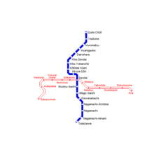
Sendai Metro Map
650 x 650
- 4,692k -
png