Manville, Wyoming
Manville: town of the United States
About
Manville is a town located in the county of Niobrara in the U.S. state of Wyoming. Its population at the 2010 census was 95 and a population density of 135 people per km². After 10 years in 2020 city had an estimated population of 83 inhabitants.
Quick Facts about Manville
| Population | 83 (2020) |
| Country | United States of America |
| State | Wyoming (United States) |
| County | Niobrara County |
| Postal code | 82227 |
| Phone Area Codes | 307 |
| Area | 0.7 km2 |
| Official name | Manville, Wyoming |
| Latitude & Longitude | 42.7791,-104.6177 |
| Altitude | 5,253 feet / 1601 meters |
| Time Zone | America/Denver |
| Local time | 02:55:18 (27th June 2026) |
| Density | 118 Pop. per km² as of 2020 |
| Population growth | -14.46% (2010-2020) |
| Weather | 56℉ Mostly Clear 7-days weather |
Geography
Manville is located at 42°46'45"N 104°37'4"W (42.7791300, -104.6177400).
Manville map
Weather
Mostly clear, with a low around 56. South wind 15 to 25 mph, with gusts as high as 40 mph. New rainfall amounts less than a tenth of an inch possible.
7-Day ForecastDemographics
According to census records, the population of Manville decreased by 14.46% in 10 years.
| Year | Population | % Change | Method |
|---|---|---|---|
| 2010 | 95 | - | census |
| 2011 | 94 | -1.06% | estimation process |
| 2012 | 93 | -1.08% | estimation process |
| 2013 | 95 | 2.11% | estimation process |
| 2014 | 93 | -2.15% | estimation process |
| 2015 | 93 | 0% | estimation process |
| 2016 | 92 | -1.09% | estimation process |
| 2017 | 88 | -4.55% | estimation process |
| 2018 | 88 | 0% | estimation process |
| 2019 | 87 | -1.15% | estimation process |
| 2020 | 83 | -4.82% | estimation process |
Demographic Facts
| Estimated population as of July 1, 2019 : | 7,233 |
| Based on demographic estimates as of April 1, 2010 : | 6,182 |
| Based on demographic estimates as of 1 April 2010 : | 17.0% |
| April 1, 2020 Population : | 6,747 |
| April 1, 2010 Population : | 6,046 |
| People under 5 years old, percentage : | 11.4% |
| People under 18 years old, percentage : | 36.9% |
| People over 65 (%) : | 8.7% |
| Female persons, % : | 48.8% |
| White only, percent : | 83.4% |
| Black or African American alone, percent : | 0.7% |
| American Indian and Alaska Native only, % : | 6.1% |
| Asians alone % : | 1.1% |
| Only Native Hawaiians and Other Pacific Islanders, % : | 0.4% |
| % of people who have participated in two or more races : | 3.4% |
| % of Hispanic or Latino : | 13.0% |
| White people, not Hispanic or Latino people, make up the majority of the population. : | 76.4% |
| 2015-2019 Veterans : | 316 |
| Percentage of foreign-born people, 2015-2019 : | 5.2% |
| Rate of owner-occupied housing units, 2015-2019 : | 65.8% |
Economic Facts
| Rate of owner-occupied housing units, 2015-2019 : | 65.8% |
| Owner-occupied housing unit median value, 2015-2019 : | $199,600 |
| From 2015 to 2019, the median selected monthly owner costs - with a mortgage : | $1,375 |
| Monthly owner costs, without a mortgage, at the median, 2015-2019 : | $424 |
| 2015-2019 median gross rent : | $800 |
| 2015-2019 Households : | 2,397 |
| Population per household, 2015-2019 : | 2.91 |
| Living in the same house a year ago, percentage of people aged one year and up, 2015-2019 : | 83.3% |
| Languages other than English spoken at home, as a percentage of people aged 5 and up, 2015-2019 : | 11.5% |
| Households with computers, %, 2015-2019 : | 91.9% |
| Percentage of households with a broadband Internet subscription, 2015-2019 : | 85.5% |
| Percentage of people aged 25 and up with a high school diploma or higher, 2015-2019 : | 88.7% |
| Bachelor's degree or higher, proportion of people aged 25 and up, 2015-2019 : | 19.4% |
| Percentage of people under the age of 65 who have a disability, 2015-2019 : | 8.6% |
| Persons under the age of 65 who do not have health insurance, as a percentage : | 14.9% |
| Total civilian labor force, percent of population aged 16 and up, 2015-2019 : | 69.4% |
| Female labor force participation in the civilian labor force, as a percentage of the population aged 16 and up, 2015-2019 : | 59.2% |
| 2012 total retail sales ($1,000) : | 202,468 |
| 2012 total retail sales per capita : | $32,087 |
| Mean commute time to work (in minutes), workers aged 16 and up, 2015-2019 : | 15.9 |
| 2015-2019 median household income (in 2019 dollars) : | $63,479 |
| Income per capita in the previous 12 months (in 2019 dollars), 2015-2019 : | $24,738 |
| Percentage of people living in poverty : | 14.3% |
| Total number of businesses in 2012 : | 1,046 |
| Men-owned businesses in 2012 : | 472 |
| Women-owned businesses in 2012 : | 188 |
| Minority-owned businesses in 2012 : | 68 |
| Non-minority-owned businesses in 2012 : | 932 |
| Veteran-owned businesses in 2012 : | F |
| Nonveteran-owned businesses in 2012 : | 903 |
| 2010 population per square mile : | 1,085.0 |
| 2010 land area in square miles : | 5.57 |
Services and Civic Places in Manville
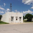
1Manville Town Hall
651 5th St, Manville, WY 82227 View details
Phone: +13073342142
Nearby Transit Stations (2)
Rail and bus stations connected to Manville, WY. Select a station to open its map and address details.
| Code | Name | Address | Type |
|---|---|---|---|
| DGS | Douglas, Wyoming | 628 East Richards St. | BUS |
| WHT | Wheatland, Wyoming | 1857 West Mariposa Parkway | BUS |
Closest post offices linked to Manville.
| Post Office Name | City | ZIP |
|---|---|---|
| Manvill Post Office | Manville (WY) | 82227 |
Other places with the same name (1)
- Manville, New Jersey borough in Somerset County, New Jersey with a population of 10,046 people.
Other cities in Niobrara County
Cities, towns, neighborhoods & other populated places in Niobrara County , WY.
| City Name | Population | Title |
|---|---|---|
| Lusk | 1,474 | Town in Wyoming |
| Van Tassell | 17 | Town of the United States |