Kandahar (Kandahār), Kandahar
Kandahar: This southern Afghan city, with a population of approximately 391, 190, is one of the country's largest and most historically significant.
About
Quick Facts about Kandahār
| Population | 391,190 |
| Country | Afghanistan |
| State | Kandahar (Afghanistan) |
| County | Kandahar District |
| Area | 54022 km2 |
| Latitude & Longitude | 31.6133,65.7101 |
| Official language | Pashto |
| Altitude | 3,990 feet / 1216 meters |
| Capital | Kandahar |
| Time Zone | UTC+04:30 |
| Local time | 23:56:11 (2nd August 2026) |
Geography
Kandahār is located at 31°36'48"N 65°42'36"E (31.6133200, 65.7101300).
Kandahar map
Click "full screen"  icon to open full mode. View satellite images
- Ghorak District
- Daman District
- Arghistan District
- Nesh District
- Kandahar District
- Reg District
- Spin Boldak District
- Shah Wali Kot District
- Arghandab District
- Khakrez District
- Maruf District
- Maywand District
- Zhari District
- Miyanishin District
- Panjwayi District
- Shorabak District
Candahar, KDH, Kandagar, Kandaharo, Kandehar, Kandhar, Qandahar, Qandahār, Qanḏahāṟ, kan da ha, kandaharu, kndhar, qndhar, qndhʼr, Кандагар, קנדהאר, قندهار, كندهار, カンダハール, 坎大哈
Map & Images (more maps)
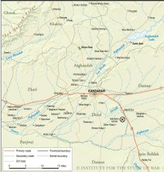
Central Kandahar
1200 x 1253
- 359,085k -
PNG
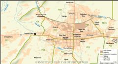
Kandahar City
1600 x 865
- 208,890k -
PNG
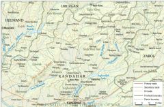
Kandahar North
1750 x 1143
- 690,962k -
PNG