Kabul (Kābūl), Northern District
Kabul: capital of Afghanistan
About
Quick Facts about Kābūl
| Population | 9,497 |
| Country | Afghanistan |
| State | Northern District (Israel) |
| Area | 275 km2 |
| Latitude & Longitude | 32.8686,35.2117 |
| Altitude | 5,873 feet / 1790 meters |
| Capital city | Kābūl is capital of Durrani Empire, Democratic Republic of Afghanistan, Kabul Shahi, Transitional Islamic State of Afghanistan, Q31073139, Kabul District, Afghanistan, Kabul, Islamic State of Afghanistan, Kingdom of Afghanistan, Republic of Afghanistan, Emirate of Afghanistan, Islamic Emirate of Afghanistan, Durrani Empire |
| Establishment | January 01, 1200 (826 years ago) |
| Time Zone | UTC+04:30 |
| Local time | 00:22:33 (25th July 2026) |
Geography
Kābūl is located at 32°52'7"N 35°12'42"E (32.8685600, 35.2117100).
Kabul map
Click "full screen"  icon to open full mode. View satellite images
- Istanbul
- Tehran
Kavul, kabwl, kbwl, kʼbwl, כאבול, כבול, كابول
Map & Images (more maps)
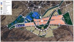
Kabulcitymap
1484 x 857
- 302,674k -
jpg
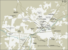
Kabul City Map
920 x 677
- 60,146k -
png
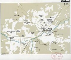
Map of Kabul, Afghanistan Cia, 1980
2625 x 2208
- 417,988k -
jpg