MapSof
.net
Places
Countries
States
Capital Cities
All Places
Maps
Physical Maps
Political Maps
Historical Maps
All Maps
Tools
Distance Calculator
Address Locator
Geocoder
Street View
Coordinate Finder
Distances
Countries
States
Cities
Maps
Distance Calculator
Geocoder
Distances
Home
/
Asia
/
India
/
Kerala
/
State of Kerala
/
Maps
State of Kerala
Maps
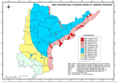
Hazard Map of Andhra Pradesh
1400 x 989 - 121,044k - png
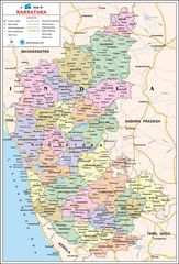
Political Map of Karnataka
900 x 1324 - 260,535k - jpg
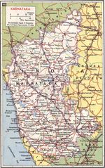
Transport Map of Karnataka
816 x 1300 - 304,940k - jpg