Santorini (Santorini Island), South Aegean
Santorini:
About
Quick Facts about Santorini Island
| Country | Greece |
| State | South Aegean (Greece) |
| County | Nomós Kykládon |
| Latitude & Longitude | 36.4057,25.4568 |
| Time Zone | Europe/Athens |
| Local time | 22:45:16 (24th July 2026) |
Geography
Santorini Island is located at 36°24'21"N 25°27'25"E (36.4057200, 25.4568200).
Santorini map
Click "full screen"  icon to open full mode. View satellite images
Kallisti, Kallísti, Nisi Santorini, Nisi Thira, Nisos Santorini, Nisos Thira, Nisí Santoríni, Nisí Thíra, Nísos Santoríni, Nísos Thíra, Phira, Sandorini, Sandoríni, Santori, Santorin, Santorino, Santoron, Santoryn, Santorí, Santorín, Santoríni, Thera, Thira, Thíra, Thēra, Tira, santorini dao, sheng tuo li ni, sntwryny, Θήρα, Νήσος Θήρα, Νήσος Σαντορίνη, Νησί Θήρα, Νησί Σαντορίνη, Σαντορίνη, Санторини, Тира, סנטוריני, サントリーニ島, 圣托里尼
Map & Images (more maps)
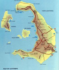
Santorini Map
1824 x 2164
- 602,068k -
jpg
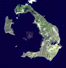
Santorini Satellite Image
1191 x 1230
- 152,207k -
jpg
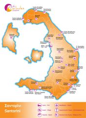
Santorini Touristic Map
1238 x 1688
- 253,623k -
jpg
Thira Island Santorini Map
1430 x 1500
- 438,830k -
gif