England, England
England: country in north-west Europe, part of the United Kingdom
About

State Snapshot
England at a glance
England currently has 2,070 quality-checked populated place pages and 131 county pages linked on MapSof.
Mapped cities & towns
2,070
These counts use a stricter populated-place filter so the main lists stay focused on real city and town pages.
County pages
131
Open related pagesLargest city
WashingtonPopulation 7,693,612
Top linked places
Quick Facts about England
| Population | 55,268,100 |
| Country | United Kingdom, Great Britain, United Kingdom of Great Britain and Ireland |
| State | England (United Kingdom) |
| Different from | Kingdom of England |
| Area | 130278.43 km2 |
| Official name | England |
| Continent | Europe |
| Easternmost point | Point(1.762833333 52.481166666) |
| Northernmost point | Point(-2.033333333 55.8) |
| Latitude & Longitude | 52.1605,-0.7031 |
| Patron saint | Saint George |
| Legislative body | Parliament of the United Kingdom |
| Official language | English |
| Capital | London |
| Time Zone | Europe/London, Western European Time, Greenwich Mean Time |
| Local time | 18:51:21 (24th July 2026) |

Geography
England is located at 52°9'38"N 0°42'11"W (52.1604500, -0.7031200). It has 2 neighbors: Wales and Scotland.
England map
The largest city of England is Birmingham with a population of 1,137,100. Other cities include, Sheffield population 685,368, Liverpool population 513,441, Leeds population 455,123 and Coventry population 362,690. See all England cities & populated places.
Largest Cities in England (more)
Cities, Towns, Villages, Neighborhoods & Other Populated Places in England.
| City Name | County | Population |
|---|---|---|
| Washington | Sunderland | 7,693,612 |
| Birmingham | City and Borough of Birmingham | 1,137,100 |
| Sheffield | Sheffield | 685,368 |
| Manchester | Manchester | 547,627 |
| Liverpool | Liverpool | 513,441 |
| Leeds | City and Borough of Leeds | 455,123 |
| Halifax | Calderdale | 424,931 |
| Coventry | Coventry | 362,690 |
| Birkenhead | Metropolitan Borough of Wirral | 325,264 |
| Nottingham | Nottingham | 321,500 |
| Preston | Lancashire | 313,332 |
| Bradford | Bradford | 293,277 |
| Sunderland | Sunderland | 277,417 |
| Plymouth | Plymouth | 260,203 |
| Wolverhampton | Wolverhampton | 252,791 |
| Portsmouth | Portsmouth | 248,440 |
Show more England cities and populated places
Official website of England
Official Website- South East England
- West Midlands
- Yorkshire and the Humber
- North West England
- East Midlands
- London
- South West England
- East of England
- North East England
Demographics
| Year | Population | % Change | Method |
|---|---|---|---|
| 1801 | 8,331,434 | - | census |
| 1811 | 9,538,827 | 12.66% | census |
| 1821 | 11,281,957 | 15.45% | census |
| 1831 | 13,090,615 | 13.82% | census |
| 1841 | 15,002,250 | 12.74% | census |
| 1851 | 16,921,972 | 11.34% | census |
| 1901 | 32,544,685 | 48% | census |
| 1971 | 43,460,525 | 25.12% | census |
| 1981 | 45,978,080 | 5.48% | census |
| 1991 | 48,197,672 | 4.61% | census |
| 2001 | 49,138,831 | 1.92% | census |
| 2011 | 53,012,456 | 7.31% | census |
| 2015 | 54,786,300 | 3.24% | estimation process |
| 2016 | 55,268,100 | 0.87% | estimation process |
England Counties (more)
Greater London

administrative area, ceremonial county in England (excluding City of London)
Hampshire
ceremonial county of England (use Q21694653 for administrative non-metropolitan county)
County Durham
ceremonial county in North East England, United Kingdom
| County Name | Population |
|---|---|
| Greater London | 8,308,369 |
| Hampshire | 1,844,245 |
| County Durham | 883,269 |
| City and Borough of Leeds | 789,194 |
| City of Bristol | 463,405 |
| London Borough of Barnet | 392,140 |
| City of Leicester | 355,218 |
| City and Borough of Wakefield | 345,038 |
| London Borough of Ealing | 341,982 |
| London Borough of Bromley | 331,096 |
| Nottingham | 331,069 |
| Borough of Wigan | 326,088 |
| London Borough of Lambeth | 325,917 |
| Borough of Doncaster | 310,542 |
| London Borough of Hillingdon | 304,824 |
| London Borough of Lewisham | 303,536 |
Show more England counties
Map & Images (more maps)
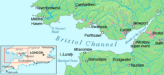
Bristol Channel Detailed Map
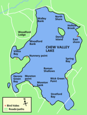
Chew Valley Lake Map
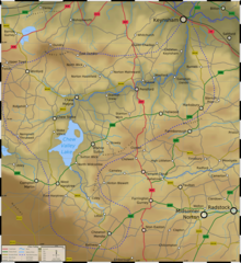
Chew Valley Map
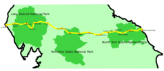
Coast 2 Coast
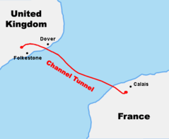
Course Channeltunnel En
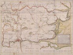
Diocese of London Survey By John Harris 1714
England Uk
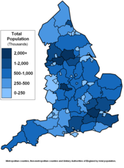
England Counties Population
English 1998 Admin Areas Flood Damage July 24 2007
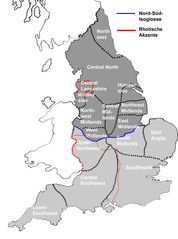
English Dialects

English Counties Flood Damage July 24 2007
English Counties Flooded In 2007

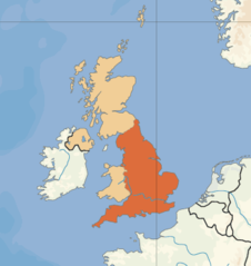
Europe Location Eng
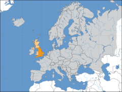
Europelocation England
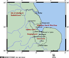
Fens Omc
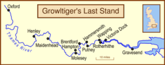
Growltiger Placenames
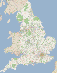
England Large Map 1
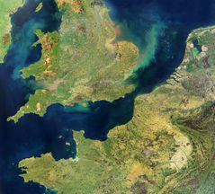
England Satellite Image
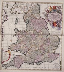
England Political And Historical Map
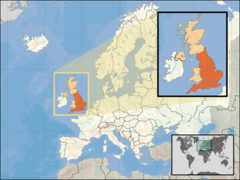
Where Is England Located