Calgary, Alberta
Calgary: Located in southern Alberta, this Canadian city serves as a hub for the oil and gas industry, contributing significantly to the nation's economy.
About

Quick Facts about Calgary
| Population | 1,239,220 |
| Country | Canada |
| State | Alberta (Canada) |
| Postal code | T3, T1, T2 |
| Phone Area Codes | 403, 587, 825 |
| Official name | Town of Calgary, City of Calgary |
| Latitude & Longitude | 51.0501,-114.0853 |
| Legislative body | Calgary City Council |
| Named for | Calgary |
| Altitude | 3,428 feet / 1045 meters |
| Time Zone | UTC−07:00 |
| Local time | 14:11:15 (24th July 2026) |
Calgary Alberta Location locator map image
Geography
Calgary is located at 51°3'0"N 114°5'7"W (51.050112282, -114.085285152).
Calgary map
Click "full screen"  icon to open full mode. View satellite images
Official website of Calgary
Official Website- Daejeon
- Daqing
- Jaipur
- Mazkeret Batya
- Naucalpan de Juárez Municipality
- Phoenix
- Quebec City
- Sarajevo
Demographics
| Year | Population | % Change | Method |
|---|---|---|---|
| 2011 | 1,096,833 | - | census |
| 2016 | 1,239,220 | 11.49% | census |
Kalgari, Kalgario, Калгари, קלגרי, کالگری, カルガリー, 卡尔加里, 캘거리
Map & Images (more maps)
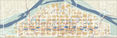
Calgary Downtown Bus Map
2400 x 790
- 248,154k -
png
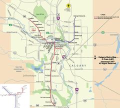
Calgary Metro Map (subway)
912 x 819
- 113,222k -
jpg
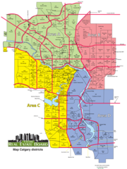
Calgary Zones Map
1348 x 1800
- 200,050k -
png
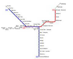
Calgary Metro Map
681 x 547
- 5,949k -
png