Grasonville, Maryland
Grasonville: census designated place
About
Grasonville is a CDP located in the county of Queen Anne's in the U.S. state of Maryland.

Quick Facts about Grasonville
| Population | 3,425 |
| Country | United States of America |
| State | Maryland (United States) |
| County | Queen Anne's County |
| Postal code | 21638 |
| Area | 16.29 km2 |
| Latitude & Longitude | 38.9582,-76.2102 |
| Altitude | 16 feet / 5 meters |
| Time Zone | America/New_York |
| Local time | 05:57:15 (15th July 2026) |
| Weather | 91℉ Sunny 7-days weather |

Geography
Grasonville is located at 38°57'29"N 76°12'37"W (38.9581700, -76.2102300).
Grasonville map
Weather
Sunny, with a high near 91. Heat index values as high as 101. West wind 5 to 10 mph.
7-Day ForecastBest Things to Do in Grasonville
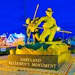
1Watermen's Monument
Grasonville, MD 21638, United States View details
Nearby Schools and Colleges
Schools and campuses linked to Grasonville, MD. Select a name to open its map and contact details.
| Code | Name | City | ZIP |
|---|---|---|---|
| 162168 | Chesapeake College | Wye Mills (MD) | 21679-0008 |
Nearby Transit Stations (26)
Rail and bus stations connected to Grasonville, MD. Select a station to open its map and address details.
| Code | Name | Address | Type |
|---|---|---|---|
| KNT | Kent Island, MD | 3206 Main Street | BUS |
| ESN | Easton Airport, Maryland | 29137 Newman Road | BUS |
| CDE | Cambridge, Maryland | 100 Heron Boulevard | BUS |
| BWI | BWI Rail Station | 7 Amtrak Way | RAIL |
| BAL | Pennsylvania Station | 1515 North Charles Street | RAIL |
Closest post offices linked to Grasonville.
| Post Office Name | City | ZIP |
|---|---|---|
| Grasonvill Post Office | Grasonville (MD) | 21638 |
Other cities in Queen Anne's County
Cities, towns, neighborhoods & other populated places in Queen Anne's County , MD.
| City Name | Population | Title |
|---|---|---|
| Stevensville | 6,803 | Town in Montana, USA |
| Centreville | 4,949 | Town in Maryland, United States |
| Kingstown | 1,733 | Census designated place in Maryland, United States |
| Church Hill | 747 | Town in Queen Anne's County, Maryland, United States |
| Sudlersville | 487 | Town of the United States |
| Barclay | 165 | Town of the United States |
Distance to Other Cities
Grasonville distances to largest Maryland cities