MapSof
.net
Places
Countries
States
Capital Cities
All Places
Maps
Physical Maps
Political Maps
Historical Maps
All Maps
Tools
Distance Calculator
Address Locator
Geocoder
Street View
Coordinate Finder
Distances
Countries
States
Cities
Maps
Distance Calculator
Geocoder
Distances
Home
/
Europe
/
Germany
/
Federal Republic of Germany
/
Maps
Federal Republic of Germany
Maps
Germany Flag Map
1800 x 2436 - 133,486k - PNG
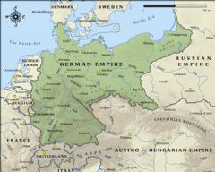
German Empire Map In 1914
1000 x 800 - 294,038k - JPG
« Previous
Next »
Showing
126
to
127
of
127
results
1
2
3
4
5
6