Erfurt, Thuringia
Erfurt: capital city of German federated state of Thuringia
About
Quick Facts about Erfurt
| Population | 213,699 |
| Country | Kingdom of Prussia, German Democratic Republic, German Empire, Soviet occupation zone (Germany), Principality of Erfurt, Germany, Weimar Republic, Allied-occupied Germany, Germany |
| State | Thuringia (Germany) |
| County | Bous |
| Postal code | 99094, 99090, 99084, 99096, 99086, 99087, 99097, 99098, 99092, 99095, 99089, 99085, 99091, 99099 |
| Plate code | L, LF, EF |
| Phone Area Codes | 36208, 36203, 36202, 36204, 361 |
| Area | 269.91 km2 |
| Official name | Erfurt |
| Continent | Europe |
| Latitude & Longitude | 50.9787,11.0328 |
| Altitude | 636 feet / 194 meters |
| Capital city | Erfurt is capital of Erfurt Government Region, Kreis Erfurt-Land, Erfurt District, Thuringia |
| Establishment | January 01, 0742 (1284 years ago) |
| Time Zone | UTC+02:00, UTC+01:00 |
| Local time | 15:26:04 (19th July 2026) |
Geography
Erfurt is located at 50°58'43"N 11°1'58"E (50.9787000, 11.0328300).
Erfurt map
Click "full screen"  icon to open full mode. View satellite images
Official website of Erfurt
Official Website- Győr (1971 )
- Haifa (2000 )
- Kalisz (1982 )
- Kati (2009 )
- Lille (1988 )
- Lovech (1996 )
- Lovech Municipality
- Mainz (1988 )
- Piacenza
- San Miguel de Tucumán (1993 )
- Shawnee (1993 )
- Vilnius (1972 )
- Xuzhou (2005 )
- Gispersleben
- Q501573
- Q1350186
- Rieth
- Töttleben
- Ilversgehofen
- Schmira
- Bischleben
- Q1919094
- Hochheim (Erfurt)
- Linderbach
- Alach
- Ermstedt
- Kerspleben
- Q2365114
- Q996937
- Molsdorf
- Möbisburg-Rhoda
- Büßleben
- Mittelhausen
- Windischholzhausen
- Dittelstedt
- Marbach (Erfurt)
- Vieselbach
- Waltersleben
- Egstedt
- Roter Berg
- Schwerborn
- Bindersleben
- Kühnhausen
- Urbich
- Q1350171
- Töttelstädt
- Q1879601
- Johannesplatz
- Tiefthal
- Gottstedt
- Altstadt (Erfurt)
- Stotternheim
- Q2569461
- Wallichen
- Hohenwinden
- Q1790567
- Schaderode
- Rohda
- Daberstedt
- Salomonsborn
- Frienstedt
- Berliner Platz (Erfurt)
- Azmannsdorf
- Niedernissa
- Hochstedt
Demographics
| Year | Population | % Change | Method |
|---|---|---|---|
| 1493 | 18,680 | - | statistical updating |
| 1511 | 16,000 | -16.75% | statistical updating |
| 1569 | 18,000 | 11.11% | register office |
| 1620 | 19,000 | 5.26% | project management estimation |
| 1624 | 13,884 | -36.85% | statistical updating |
| 1632 | 13,000 | -6.8% | register office |
| 1661 | 15,429 | 15.74% | register office |
| 1664 | 11,231 | -37.38% | statistical updating |
| 1682 | 16,332 | 31.23% | register office |
| 1684 | 7,000 | -133.31% | statistical updating |
| 1710 | 14,338 | 51.18% | statistical updating |
| 1740 | 17,196 | 16.62% | statistical updating |
| 1750 | 15,808 | -8.78% | statistical updating |
| 1758 | 13,602 | -16.22% | statistical updating |
| 1777 | 14,064 | 3.28% | register office |
| 1782 | 14,621 | 3.81% | register office |
| 1792 | 16,896 | 13.46% | statistical updating |
| 1798 | 17,634 | 4.19% | statistical updating |
| 1802 | 16,938 | -4.11% | statistical updating |
| 1811 | 18,154 | 6.7% | register office |
| 1950 | 189,988 | 90.44% | statistical updating |
| 1960 | 186,448 | -1.9% | statistical updating |
| 1970 | 196,528 | 5.13% | register office |
| 1980 | 211,575 | 7.11% | statistical updating |
| 1990 | 208,989 | -1.24% | register office |
| 2000 | 200,564 | -4.2% | statistical updating |
| 2010 | 204,994 | 2.16% | statistical updating |
| 2011 | 206,384 | 0.67% | statistical updating |
| 2012 | 203,485 | -1.42% | statistical updating |
| 2013 | 204,880 | 0.68% | project management estimation |
| 2014 | 206,219 | 0.65% | statistical updating |
| 2015 | 210,118 | 1.86% | register office |
| 2016 | 211,113 | 0.47% | project management estimation |
| 2017 | 212,988 | 0.88% | statistical updating |
| 2019 | 213,699 | 0.33% | statistical updating |
ERF, Ehrfurt, Erfesfurt [a. 1144], Erfordia, Erfurtas, Erfurte, Erfurti, Erfurto, Erpesforth [a. 1133], Erphesfurt [a. 742], Erphord [a. 1210], Erphourte, Erpisfurt, Erpsfordia [a. 1222], Erpsfurd [a. 1196], Jarobrod, ai er fu te, arfwrt, eafuruto, eleupuleuteu, eraphurta, Érfurt, Ερφούρτη, Ерфурт, Эрфурт, ארפורט, ערפורט, إرفورت, ارفرٹ, ارفورت, एरफुर्ट, แอร์ฟูร์ท, ერფურტი, エアフルト, 埃尔福特, 에르푸르트
Map & Images (more maps)
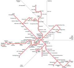
Erfurt Metro Map
839 x 776
- 16,009k -
png