Edmonton, Kentucky
Edmonton: city in Kentucky, U.
About
Edmonton is a city located in the county of Metcalfe in the U.S. state of Kentucky. Its population at the 2010 census was 1,595 and a population density of 181 people per km². After 10 years in 2020 city had an estimated population of 1,597 inhabitants.
The city was created 190 years ago in 1835.

Quick Facts about Edmonton
| Population | 1,597 (2020) |
| Country | United States of America |
| State | Kentucky (United States) |
| County | Metcalfe County |
| Postal code | 42129 |
| Phone Area Codes | 270 |
| Area | 8.82 km2 |
| Latitude & Longitude | 36.9801,-85.6122 |
| Altitude | 827 feet / 252 meters |
| Capital city | Edmonton is capital of Metcalfe County |
| Establishment | January 01, 1836 (190 years ago) |
| Time Zone | America/Chicago |
| Local time | 12:32:27 (15th July 2026) |
| Density | 181 Pop. per km² as of 2020 |
| Population growth | 0.13% (2010-2020) |
| Weather | 69℉ Partly Cloudy then Patchy Fog 7-days weather |

Geography
Edmonton is located at 36°58'48"N 85°36'44"W (36.9800600, -85.6121900).
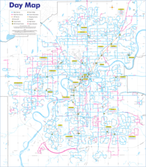
Edmonton map
Weather
Patchy fog after 4am. Partly cloudy, with a low around 69. East wind around 1 mph.
7-Day ForecastOfficial website of Edmonton
Official WebsiteDemographics
The population of Edmonton increased by 0.13% in 10 years.
| Year | Population | % Change | Method |
|---|---|---|---|
| 2010 | 1,595 | - | census |
| 2011 | 1,604 | 0.56% | estimation process |
| 2012 | 1,589 | -0.94% | estimation process |
| 2013 | 1,586 | -0.19% | estimation process |
| 2014 | 1,590 | 0.25% | estimation process |
| 2015 | 1,579 | -0.7% | estimation process |
| 2016 | 1,590 | 0.69% | estimation process |
| 2017 | 1,600 | 0.62% | estimation process |
| 2018 | 1,595 | -0.31% | estimation process |
| 2019 | 1,595 | 0% | estimation process |
| 2020 | 1,597 | 0.13% | estimation process |
Nearby Schools and Colleges
Schools and campuses linked to Edmonton, KY. Select a name to open its map and contact details.
| Code | Name | City | ZIP |
|---|---|---|---|
| 156754 | PJ's College of Cosmetology-Glasgow | Glasgow (KY) | 42141 |
Closest post offices linked to Edmonton.
| Post Office Name | City | ZIP |
|---|---|---|
| Edmonton Post Office | Edmonton (KY) | 42129 |
Distance to Other Cities
Edmonton distances to largest Kentucky cities
- Louisville
- Lexington-Fayette
- Lexington
- Bowling Green
- Owensboro
- Covington
- Richmond
- Florence
- Hopkinsville
- Nicholasville
Map & Images (more maps)
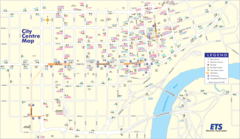
Edmonton Downtown Transport Map (city Center)
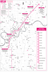
Edmonton Eddie Bus Map
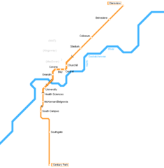
Edmonton Light Rail Map (lrt)
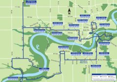
Edmonton Transport Map