East Sandwich, Massachusetts
East Sandwich: Census-designated place in Barnstable County, Massachusetts
About
East Sandwich is a CDP located in the county of Barnstable in the U.S. state of Massachusetts.

Quick Facts about East Sandwich
| Population | 3,940 |
| Country | United States of America |
| State | Massachusetts (United States) |
| County | Barnstable County |
| Postal code | 02537 |
| Area | 19.8 km2 |
| Latitude & Longitude | 41.7418,-70.4517 |
| Altitude | 30 feet / 9 meters |
| Time Zone | America/New_York |
| Local time | 20:56:07 (18th July 2026) |
Geography
East Sandwich is located at 41°44'30"N 70°27'6"W (41.7417700, -70.4516900).
East Sandwich map
Best Things to Do in East Sandwich
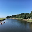
1Game Farm Property
Game Farm Driveway, East Sandwich, MA 02537, United States View details
Phone: +15088886870 | Website available
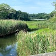
2Maple Swamp
Service Rd, East Sandwich, MA 02537, United States View details
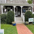
3Green Briar Nature Center and Jam Kitchen
6 Discovery Hill Rd, East Sandwich, MA 02537, United States View details
Phone: +15088886870 | Website available
4Little Free Library "WISDOM HUNTER"
44 Mill Rd, East Sandwich, MA 02537, United States View details
Website available

Nearby Schools and Colleges
Schools and campuses linked to East Sandwich, MA. Select a name to open its map and contact details.
| Code | Name | City | ZIP |
|---|---|---|---|
| 165194 | Cape Cod Community College | West Barnstable (MA) | 02668-1599 |
Nearby Transit Stations (8)
Rail and bus stations connected to East Sandwich, MA. Select a station to open its map and address details.
| Code | Name | Address | Type |
|---|---|---|---|
| RTE | Route 128 station | 50 University Ave | RAIL |
| PVD | Providence station | 100 Gaspee Street | RAIL |
| BOS | South Station | 2 South Station | RAIL |
| BBY | Back Bay station | 145 Dartmouth St. | RAIL |
| BON | North Station | 100 Legends Way | RAIL |
Closest post offices linked to East Sandwich.
| Post Office Name | City | ZIP |
|---|---|---|
| East Sandwich Post Office | East Sandwich (MA) | 02537 |
Other cities in Barnstable County
Cities, towns, neighborhoods & other populated places in Barnstable County , MA. (more)
| City Name | Population | Title |
|---|---|---|
| Barnstable | 44,535 | A town in Barnstable County, Massachusetts. |
| Falmouth | 31,107 | Town in Massachusetts, United States |
| Yarmouth | 23,166 | City in Massachusetts |
| Sandwich | 20,151 | Human settlement in Barnstable County, Massachusetts, United States of America |
| Bourne | 19,743 | Town in Barnstable County, Massachusetts, United States |
| Mashpee | 14,266 | Town in Barnstable County, Massachusetts, United States |
| Hyannis | 14,120 | Village in town of Barnstable, Barnstable County, Massachusetts, United States |
| Dennis | 13,890 | Town in Barnstable County, Massachusetts, United States |
| Harwich | 12,144 | Town on Cape Cod, in Barnstable County in the state of Massachusetts |
| South Yarmouth | 11,092 | Census-designated place in Barnstable County, Massachusetts |
| Brewster | 9,772 | Town in Massachusetts |
| Marstons Mills | 8,017 | City in Barnstable County, Massachusetts, United States of America |
| East Falmouth | 6,038 | Census-designated place in Barnstable County, Massachusetts |
| West Yarmouth | 6,012 | Census-designated place in Barnstable County, Massachusetts |
| Chatham | 5,994 | Town in Massachusetts, USA |
| Orleans | 5,802 | Town of Barnstable County, Massachusetts, United States |
Distance to Other Cities
East Sandwich distances to largest Massachusetts cities