How far is Scottsboro, AL from Opelika, AL?
The driving distance from Scottsboro, AL to Opelika, AL is about 184.8 miles (297.4 km), with a travel time of about 03h 28m by car.
- The straight-line flight distance is about 145 miles (233.4 km).
- For a round trip, plan for roughly 06h 56m of driving time before adding stops, traffic, or weather delays.
- A comfortable departure window is usually 6:00 AM to 8:00 AM CDT.
Reverse, save, or send this route
This drive is better planned with a longer stop or an overnight stay. Copy the route link, send it to another device, or print a clean version before you head out.
This drive is better planned with a longer stop or an overnight stay.
Flight Distance
Driving Distance
Gas Cost Calculator
Leave and Arrive Planner
Pick a departure time to see your estimated arrival and same-day return window.
Drive time stays fixed at 03h 28m.
An early departure helps you fit a real stop into the day without turning the return into a late-night drive.
This departure sits inside the recommended comfort window for the route.
Halfway Point
A useful midpoint for breaks, coffee, or meeting in the middle.
City in Talladega County, Alabama, United States
Route Weather Snapshot
Check the forecast at both ends before you head out.
Showers And Thunderstorms Likely
Slight Chance Showers And Thunderstorms
Driving Route Map
The map below follows the saved road route between Scottsboro and Opelika.
Turn-by-Turn Driving Directions
Step-by-step road directions between Scottsboro and Opelika.
-
1
Start on the route
30 m · 8 sec
-
2
Turn left onto South Broad Street
124 m · 20 sec · South Broad Street
-
3
Turn right onto East Willow Street
1.1 km · 1 min · East Willow Street
-
4
Turn right onto Bynum Street
91 m · 9 sec · Bynum Street
-
5
Continue on Veterans Drive
13.5 mi · 19 min · Veterans Drive
-
6
Continue on West Main Street
8.9 mi · 12 min · West Main Street
-
7
Continue on Love Road
3.7 mi · 5 min · Love Road
-
8
Take the ramp right
1413 ft · 34 sec
-
9
Merge slight left
37.1 mi · 40 min
-
10
Take the exit slight right toward AL 77: Attalla, Rainbow City
1432 ft · 49 sec
-
11
Turn right onto Gilbert Ferry Road Southeast
2742 ft · 1 min · Gilbert Ferry Road Southeast
-
12
Continue on West Grand Avenue
40.9 mi · 1 hr · West Grand Avenue
-
13
Turn right onto Western Bypass
22.7 mi · 26 min · Western Bypass
-
14
Continue on Rockford Highway
1 mi · 1 min · Rockford Highway
-
15
Turn left
1244 ft · 34 sec
-
16
Merge slight left
62.6 mi · 1 hr 15 min
-
17
Turn left onto Pepperell Parkway
1.5 km · 2 min · Pepperell Parkway
-
18
Continue on 2nd Avenue
1.4 km · 2 min · 2nd Avenue
-
19
Turn right onto North 10th Street
1793 ft · 50 sec · North 10th Street
-
20
Turn left onto Avenue B
142 m · 23 sec · Avenue B
-
21
Turn right onto South 9th Street
25 m · 4 sec · South 9th Street
-
22
Arrive at your destination
0 m · 1 sec · South 9th Street
Car Route Details
A richer read on the saved driving route between Scottsboro and Opelika.
Straightforward drive
The saved road route has a manageable number of maneuvers and should be easy to follow with normal attention to signs.
Rockford Highway
Merge slight left
62.6 mi · 01h 15m
Route Summary
A quick read on whether this route feels easy, ambitious, or worth planning around.
A longer out-and-back drive
This is still possible in one day, but it becomes a long driving day. Leaving early and planning your stop window matters more here.
Showers And Thunderstorms Likely leaving Scottsboro and Slight Chance Showers And Thunderstorms near Opelika.
Trip Questions
Direct answers travelers usually want before committing to the drive.
How long does it take to drive from Scottsboro to Opelika?
The road trip is about 184.8 miles (297.4 km) and usually takes 03h 28m in normal driving conditions.
Is this a same-day trip or an overnight route?
This is still possible in one day, but it becomes a long driving day. Leaving early and planning your stop window matters more here.
What is the halfway point on this route?
Lincoln is a useful midpoint, sitting about 97.4 miles from Scottsboro and 87.4 miles from Opelika.
How much longer is the road route than the straight-line distance?
The direct path is about 145 miles (233.4 km), while the road route adds roughly 39.8 extra miles because roads do not follow the straight air line.
When is the best time to leave for this route?
A good departure window is usually 6:00 AM to 8:00 AM CDT. If you want a more comfortable same-day return, try to leave by 10:04 AM CDT.
How much will gas cost for this route?
Using about 28.3 MPG, regular gas is estimated at $24.69 one way or $49.38 round trip. Estimated CO2 is about 57.9 kg one way.
What should you check before leaving?
Before you leave, expect Showers And Thunderstorms Likely around Scottsboro and Slight Chance Showers And Thunderstorms near Opelika.
Stop Ideas Near Lincoln
Useful break, food, and waypoint ideas within about 15 miles of the route midpoint.

Pell City Recreation Hall
Lincoln City Hall
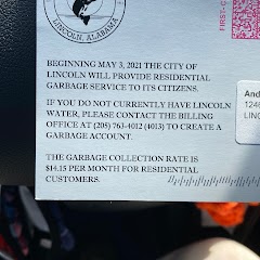
City of Lincoln Water Department
Transit and Meeting Points
Useful pickup, handoff, or rendezvous points close to Lincoln.
Anniston
Birmingham
Flight Path Map
This map shows the direct air route between Scottsboro and Opelika. Straight-line distance: 145.03 mi (233.41 km).

#1 Scottsboro
City in Alabama
| Population | 14,372 |
| Coordinates | 34.6723100, -86.0341500 |
| Altitude | 196 |
| Country | United States |

#2 Opelika
City in Alabama
| Population | 31,135 |
| Coordinates | 32.6454100, -85.3782800 |
| Altitude | 246 |
| Country | United States |
End: South 9th Street (-85.378252, 32.645431)
Estimated Travel Time
Distance: 297 km by road
| Speed | Time |
|---|---|
| 30 mph (48.3 km/h) | 06h 09m |
| 40 mph (64.37 km/h) | 04h 37m |
| 50 mph (80.47 km/h) | 03h 41m |
| 60 mph (96.56 km/h) | 03h 04m |
| 70 mph (112.65 km/h) | 02h 38m |
| 80 mph (129 km/h) | 02h 18m |
Fuel, Round Trip and CO2
Estimated fuel cost and emissions for this route.
| Fuel | $/gal | One way | Round trip |
|---|---|---|---|
| Regular gas | $3.79 | $24.69 | $49.38 |
| Mid-grade | $4.26 | $27.77 | $55.54 |
| Premium | $4.63 | $30.15 | $60.31 |
| Diesel | $5.42 | $35.31 | $70.61 |
Assumes 8.3 L/100 km (about 28.3 MPG). CO2 is an estimate and varies by vehicle, fuel blend, traffic, and terrain.
Prices in Alabama · Jun 21, 2026
Distance to Other Cities
Planning a road trip? See the full trip guide on Trip.ovh — stops, fuel costs, weather, and departure timing.