How far is Port Washington, WI from Racine, WI?
Fastest route
The distance from Port Washington, Wisconsin to Racine, Wisconsin is approximately 50.9 miles (82 kilometers). The estimated travel time is 1 hour and 12 minutes. The suggested route is via I-43 S and WI-32 S.
Directions
To get from Port Washington to Racine, follow these directions:
- Head north on S Webster St toward W Grand Ave/I-43ALT.
- Turn left onto W Grand Ave/I-43ALT.
- Turn left onto WI-32 S/I-43ALT/S Spring St. Continue to follow WI-32 S/I-43ALT.
- Turn left to merge onto I-43 S/WI-32 S/WI-57 S toward Milwaukee.
- Continue on I-43 S to Cudahy.
- Merge onto I-43 S/WI-32 S/WI-57 S. Continue to follow I-43 S.
- Take exit 72B to merge onto I-794 E toward Lakefront.
- Keep right to stay on I-794 E.
- Continue straight to stay on WI-794 S.
- Continue on S Pennsylvania Ave. Take WI-32 S to N Main St in Racine.
- Use the right two lanes to turn right onto WI-794 S/John R. Plewa Mem Lk Pkwy/S Pennsylvania Ave.
- Continue straight onto Nicholson Ave/S Pennsylvania Ave.
- Turn left onto E Forest Hill Ave.
- Turn right onto S Chicago Rd.
- Keep right to continue on WI-32 S/S Chicago Rd. Continue to follow WI-32 S.
- Pass by Pizza Hut (on the left in 9 miles).
- Turn left onto Hamilton St.
- Turn right onto N Main St.
Tips & Suggestions
- 🚗 Make sure to plan your trip in advance to account for traffic conditions and potential delays.
- ⛽ It's a good idea to fill up your gas tank before embarking on the journey to avoid running out of fuel.
- 📱 Use a reliable navigation app or GPS device to guide you along the route and provide real-time updates.
- 🚦 Pay attention to road signs and follow the indicated directions to stay on the correct path.
- 🛣️ Stay alert and obey traffic laws while driving to ensure a safe and smooth journey.
- 🍴 Consider stopping for a meal or snacks along the way to keep yourself energized during the trip.
- 🚧 Be aware of any ongoing road construction or detours that may affect your route and plan accordingly.
Reverse, save, or send this route
This route works well as a day trip with time at the destination. Copy the route link, send it to another device, or print a clean version before you head out.
This route works well as a day trip with time at the destination.
Flight Distance
Driving Distance
Gas Cost Calculator
Leave and Arrive Planner
Pick a departure time to see your estimated arrival and same-day return window.
Drive time stays fixed at 01h 05m.
A morning start gives you useful time at the destination and keeps the return out of the late evening.
You are leaving earlier than the recommended window, which gives you extra margin for breaks and traffic.
Halfway Point
A useful midpoint for breaks, coffee, or meeting in the middle.
The thirtieth most populous city in the United States and the center of the Milwaukee metropolitan area.
Route Weather Snapshot
Check the forecast at both ends before you head out.
Smoke
Smoke
Driving Route Map
The map below follows the saved road route between Port Washington and Racine.
Turn-by-Turn Driving Directions
Step-by-step road directions between Port Washington and Racine.
-
1
Start on South Webster Street
32 m · 10 sec · South Webster Street
-
2
Turn left onto West Grand Avenue
2615 ft · 52 sec · West Grand Avenue
-
3
Turn left onto South Spring Street
3.9 mi · 6 min · South Spring Street
-
4
Turn left onto I 43 South, WI 32, WI 57
26.6 mi · 34 min
-
5
Keep slight left to continue on North-South Freeway
939 ft · 16 sec · North-South Freeway
-
6
Continue on North-South Freeway
13 mi · 15 min · North-South Freeway
-
7
Take the exit slight right toward CTH K: Racine, Caledonia
1682 ft · 31 sec
-
8
Turn left onto Northwestern Avenue
5.1 mi · 10 min · Northwestern Avenue
-
9
Enter the roundabout and take exit 1 toward Northwestern Avenue
8 m · 1 sec · Northwestern Avenue
-
10
Exit the roundabout onto Northwestern Avenue
3.4 mi · 6 min · Northwestern Avenue
-
11
Enter the roundabout and take exit 2 toward Northwestern Avenue
28 m · 2 sec · Northwestern Avenue
-
12
Exit the roundabout onto Northwestern Avenue
2024 ft · 34 sec · Northwestern Avenue
-
13
Enter the roundabout and take exit 2 toward State Street
22 m · 4 sec · State Street
-
14
Exit the roundabout onto State Street
1.6 km · 2 min · State Street
-
15
Turn right onto Main Street
1759 ft · 40 sec · Main Street
-
16
Turn right onto 6th Street
94 m · 18 sec · 6th Street
-
17
Turn left onto Wisconsin Avenue
87 m · 14 sec · Wisconsin Avenue
-
18
Turn left onto 7th Street
75 m · 8 sec · 7th Street
-
19
Arrive at your destination
0 m · 1 sec · 7th Street
Car Route Details
A richer read on the saved driving route between Port Washington and Racine.
Highway-focused drive
Most of the mileage stays on named highways, so the important moments are ramps, exits, merges, and the final local approach.
I 43 South
Turn left onto I 43 South, WI 32, WI 57
26.6 mi · 00h 34m
Route Summary
A quick read on whether this route feels easy, ambitious, or worth planning around.
A comfortable day-trip route
This route works well as a day trip. You can leave in the morning, spend meaningful time at the destination, and still return the same day.
Smoke leaving Port Washington and Smoke near Racine.
Trip Questions
Direct answers travelers usually want before committing to the drive.
How long does it take to drive from Port Washington to Racine?
The road trip is about 55 miles (88.5 km) and usually takes 01h 05m in normal driving conditions.
Is this a same-day trip or an overnight route?
This route works well as a day trip. You can leave in the morning, spend meaningful time at the destination, and still return the same day.
What is the halfway point on this route?
Milwaukee is a useful midpoint, sitting about 27.5 miles from Port Washington and 27.5 miles from Racine.
How much longer is the road route than the straight-line distance?
The direct path is about 45.9 miles (73.9 km), while the road route adds roughly 9.1 extra miles because roads do not follow the straight air line.
When is the best time to leave for this route?
A good departure window is usually 8:00 AM to 10:00 AM CDT. If you want a more comfortable same-day return, try to leave by 4:20 PM CDT.
How much will gas cost for this route?
Using about 28.3 MPG, regular gas is estimated at $7.32 one way or $14.63 round trip. Estimated CO2 is about 17.2 kg one way.
What should you check before leaving?
Before you leave, expect Smoke around Port Washington and Smoke near Racine.
Stop Ideas Near Milwaukee
Useful break, food, and waypoint ideas within about 15 miles of the route midpoint.
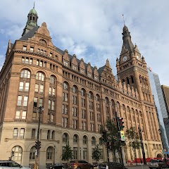
Milwaukee City Hall

West Allis City Hall

City Hall Square Apartments
Transit and Meeting Points
Useful pickup, handoff, or rendezvous points close to Milwaukee.
Milwaukee Intermodal Station
Milwaukee Airport Railroad Station
Sturtevant station
Sheboygan, Wisconsin
Flight Path Map
This map shows the direct air route between Port Washington and Racine. Straight-line distance: 45.92 mi (73.9 km).

#1 Port Washington
Fourth-class city in and county seat of Ozaukee County, Wisconsin
| Population | 1,584 |
| Coordinates | 43.3872200, -87.8756400 |
| Altitude | 183 |
| Country | United States |

#2 Racine
The second most populous city in Racine County, Wisconsin.
| Population | 76,237 |
| Coordinates | 42.7261300, -87.7828500 |
| Altitude | 188 |
| Country | United States |
End: 7th Street (-87.782849, 42.725989)
Estimated Travel Time
Distance: 89 km by road
| Speed | Time |
|---|---|
| 30 mph (48.3 km/h) | 01h 49m |
| 40 mph (64.37 km/h) | 01h 22m |
| 50 mph (80.47 km/h) | 01h 05m |
| 60 mph (96.56 km/h) | 00h 54m |
| 70 mph (112.65 km/h) | 00h 47m |
| 80 mph (129 km/h) | 00h 41m |
Fuel, Round Trip and CO2
Estimated fuel cost and emissions for this route.
| Fuel | $/gal | One way | Round trip |
|---|---|---|---|
| Regular gas | $3.77 | $7.32 | $14.63 |
| Mid-grade | $4.25 | $8.25 | $16.50 |
| Premium | $4.65 | $9.03 | $18.06 |
| Diesel | $5.30 | $10.29 | $20.58 |
Assumes 8.3 L/100 km (about 28.3 MPG). CO2 is an estimate and varies by vehicle, fuel blend, traffic, and terrain.
Prices in Wisconsin · Jul 16, 2026
Distance to Other Cities
Planning a road trip? See the full trip guide on Trip.ovh — stops, fuel costs, weather, and departure timing.