How far is Missoula, MT from Chinook, MT?
The driving distance from Missoula, MT to Chinook, MT is about 299.8 miles (482.5 km), with a travel time of about 05h 37m by car.
- The straight-line flight distance is about 251.1 miles (404.1 km).
- For a round trip, plan for roughly 11h 15m of driving time before adding stops, traffic, or weather delays.
- A comfortable departure window is usually 6:00 AM to 8:00 AM MDT.
Reverse, save, or send this route
This drive is better planned with a longer stop or an overnight stay. Copy the route link, send it to another device, or print a clean version before you head out.
This drive is better planned with a longer stop or an overnight stay.
Flight Distance
Driving Distance
Gas Cost Calculator
Leave and Arrive Planner
Pick a departure time to see your estimated arrival and same-day return window.
Drive time stays fixed at 05h 37m.
An early departure helps you fit a real stop into the day without turning the return into a late-night drive.
You are leaving earlier than the recommended window, which gives you extra margin for breaks and traffic.
Halfway Point
A useful midpoint for breaks, coffee, or meeting in the middle.
Town in Cascade County, Montana, United States
Route Weather Snapshot
Check the forecast at both ends before you head out.
Driving Route Map
The map below follows the saved road route between Missoula and Chinook.
Turn-by-Turn Driving Directions
Step-by-step road directions between Missoula and Chinook.
-
1
Start on North Higgins Avenue
6 m · 8 sec · North Higgins Avenue
-
2
Turn left onto East Broadway Street
3078 ft · 59 sec · East Broadway Street
-
3
Turn left onto Van Buren Street
133 m · 6 sec · Van Buren Street
-
4
Take the exit right
1216 ft · 30 sec
-
5
Merge slight left onto Jeannette Rankin Memorial Highway
3.9 mi · 5 min · Jeannette Rankin Memorial Highway
-
6
Take the exit slight right toward MT 200 East: Bonner, Great Falls
148.5 mi · 2 hr 48 min
-
7
Take the exit slight right toward I 15 South: Great Falls
1323 ft · 32 sec
-
8
Merge slight left onto First Special Service Force Memorial Highway
9.5 mi · 9 min · First Special Service Force Memorial Highway
-
9
Take the exit slight right toward I 15 Business
1262 ft · 31 sec
-
10
Turn left onto Central Avenue West
1.3 mi · 2 min · Central Avenue West
-
11
Turn left onto 3rd Street Northwest
1.4 mi · 2 min · 3rd Street Northwest
-
12
Continue on Smelter Avenue Northeast
2885 ft · 45 sec · Smelter Avenue Northeast
-
13
Turn left onto Old Havre Highway
1.4 km · 1 min · Old Havre Highway
-
14
Turn left onto 15th Street Northeast
107.3 mi · 1 hr 58 min · 15th Street Northeast
-
15
Turn right
3.9 mi · 5 min
-
16
Continue straight
20.8 mi · 24 min
-
17
Turn right onto Indiana Street
1775 ft · 1 min · Indiana Street
-
18
Arrive at your destination
0 m · 1 sec · Indiana Street
Car Route Details
A richer read on the saved driving route between Missoula and Chinook.
Interchange-aware route
The drive includes several ramps, exits, or merges, so checking the next few maneuvers before busy interchanges is useful.
MT 200 East
Take the exit slight right toward MT 200 East: Bonner, Great Falls
148 mi · 02h 48m
Route Summary
A quick read on whether this route feels easy, ambitious, or worth planning around.
A longer out-and-back drive
This is still possible in one day, but it becomes a long driving day. Leaving early and planning your stop window matters more here.
Sunny leaving Missoula and Smoke near Chinook.
Trip Questions
Direct answers travelers usually want before committing to the drive.
How long does it take to drive from Missoula to Chinook?
The road trip is about 299.8 miles (482.5 km) and usually takes 05h 37m in normal driving conditions.
Is this a same-day trip or an overnight route?
This is still possible in one day, but it becomes a long driving day. Leaving early and planning your stop window matters more here.
What is the halfway point on this route?
Great Falls is a useful midpoint, sitting about 149.6 miles from Missoula and 150.2 miles from Chinook.
How much longer is the road route than the straight-line distance?
The direct path is about 251.1 miles (404.1 km), while the road route adds roughly 48.7 extra miles because roads do not follow the straight air line.
When is the best time to leave for this route?
A good departure window is usually 6:00 AM to 8:00 AM MDT. If you want a more comfortable same-day return, try to leave by 5:44 AM MDT.
How much will gas cost for this route?
Using about 28.3 MPG, regular gas is estimated at $41.19 one way or $82.38 round trip. Estimated CO2 is about 94 kg one way.
What should you check before leaving?
Before you leave, expect Sunny around Missoula and Smoke near Chinook.
Stop Ideas Near Great Falls
Useful break, food, and waypoint ideas within about 15 miles of the route midpoint.
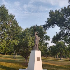
Statue of Liberty Replica
Great Falls City Attorney's Office
Cascade County Treasurer
Transit and Meeting Points
Useful pickup, handoff, or rendezvous points close to Great Falls.
Shelby
Flight Path Map
This map shows the direct air route between Missoula and Chinook. Straight-line distance: 251.09 mi (404.09 km).

#1 Missoula
The most populous city in Missoula County, Montana.
| Population | 76,848 |
| Coordinates | 46.8721500, -113.9940000 |
| Altitude | 978 |
| Country | United States |
#2 Chinook
City in Montana
| Population | 1,230 |
| Coordinates | 48.5900000, -109.2312800 |
| Altitude | 740 |
| Country | United States |
End: Chinook (-109.23128, 48.59)
Estimated Travel Time
Distance: 482 km by road
| Speed | Time |
|---|---|
| 30 mph (48.3 km/h) | 09h 59m |
| 40 mph (64.37 km/h) | 07h 29m |
| 50 mph (80.47 km/h) | 05h 59m |
| 60 mph (96.56 km/h) | 04h 59m |
| 70 mph (112.65 km/h) | 04h 16m |
| 80 mph (129 km/h) | 03h 44m |
Fuel, Round Trip and CO2
Estimated fuel cost and emissions for this route.
| Fuel | $/gal | One way | Round trip |
|---|---|---|---|
| Regular gas | $3.89 | $41.19 | $82.38 |
| Mid-grade | $4.23 | $44.76 | $89.53 |
| Premium | $4.55 | $48.13 | $96.26 |
| Diesel | $5.41 | $57.26 | $114.52 |
Assumes 8.3 L/100 km (about 28.3 MPG). CO2 is an estimate and varies by vehicle, fuel blend, traffic, and terrain.
Prices in Montana · Jul 26, 2026
Distance to Other Cities
Planning a road trip? See the full trip guide on Trip.ovh — stops, fuel costs, weather, and departure timing.