How far is Longview Heights, WA from Seattle, WA?
The driving distance from Longview Heights, WA to Seattle, WA is about 128.6 miles (207 km), with a travel time of about 02h 16m by car.
- The straight-line flight distance is about 102.8 miles (165.5 km).
- For a round trip, plan for roughly 04h 32m of driving time before adding stops, traffic, or weather delays.
- A comfortable departure window is usually 8:00 AM to 10:00 AM PDT.
Reverse, save, or send this route
This route works well as a day trip with time at the destination. Copy the route link, send it to another device, or print a clean version before you head out.
This route works well as a day trip with time at the destination.
Flight Distance
Driving Distance
Gas Cost Calculator
Leave and Arrive Planner
Pick a departure time to see your estimated arrival and same-day return window.
Drive time stays fixed at 02h 16m.
A morning start gives you useful time at the destination and keeps the return out of the late evening.
You are leaving earlier than the recommended window, which gives you extra margin for breaks and traffic.
Halfway Point
A useful midpoint for breaks, coffee, or meeting in the middle.
City in Thurston County, Washington, United States
Route Weather Snapshot
Check the forecast at both ends before you head out.
Mostly Sunny
Mostly Sunny
Driving Route Map
The map below follows the saved road route between Longview Heights and Seattle.
Turn-by-Turn Driving Directions
Step-by-step road directions between Longview Heights and Seattle.
-
1
Start on the route
9 m · 4 sec
-
2
Turn left onto Crestmont Avenue
98 m · 15 sec · Crestmont Avenue
-
3
Turn left onto Alpine Way
86 m · 18 sec · Alpine Way
-
4
Turn left onto Cedar Gates Road
155 m · 24 sec · Cedar Gates Road
-
5
Turn right onto Laulainen Road
160 m · 24 sec · Laulainen Road
-
6
Turn left onto Gates Road
766 ft · 35 sec · Gates Road
-
7
Turn right onto Columbia Heights Road
1.6 mi · 6 min · Columbia Heights Road
-
8
Turn left onto Nevada Drive
1.4 mi · 6 min · Nevada Drive
-
9
At the end of the road, turn left onto Westside Highway
1.6 mi · 3 min · Westside Highway
-
10
Turn right onto Lexington Bridge Drive
2197 ft · 1 min · Lexington Bridge Drive
-
11
Take the ramp left
1334 ft · 33 sec
-
12
Merge slight left
90.5 mi · 1 hr 44 min
-
13
Keep slight right
31.9 mi · 40 min
-
14
Take the exit slight left toward Seneca Street
1359 ft · 36 sec
-
15
Turn left onto Seneca Street
98 m · 18 sec · Seneca Street
-
16
Turn left onto 5th Avenue
615 ft · 27 sec · 5th Avenue
-
17
Turn right onto Madison Street
34 m · 9 sec · Madison Street
-
18
Turn left
9 m · 2 sec
-
19
Arrive at your destination
0 m · 1 sec
Car Route Details
A richer read on the saved driving route between Longview Heights and Seattle.
Straightforward drive
The saved road route has a manageable number of maneuvers and should be easy to follow with normal attention to signs.
Lexington Bridge Drive
Merge slight left
90.5 mi · 01h 44m
Route Summary
A quick read on whether this route feels easy, ambitious, or worth planning around.
A comfortable day-trip route
This route works well as a day trip. You can leave in the morning, spend meaningful time at the destination, and still return the same day.
Mostly Sunny leaving Longview Heights and Mostly Sunny near Seattle.
Trip Questions
Direct answers travelers usually want before committing to the drive.
How long does it take to drive from Longview Heights to Seattle?
The road trip is about 128.6 miles (207 km) and usually takes 02h 16m in normal driving conditions.
Is this a same-day trip or an overnight route?
This route works well as a day trip. You can leave in the morning, spend meaningful time at the destination, and still return the same day.
What is the halfway point on this route?
Tumwater is a useful midpoint, sitting about 64.3 miles from Longview Heights and 64.3 miles from Seattle.
How much longer is the road route than the straight-line distance?
The direct path is about 102.8 miles (165.5 km), while the road route adds roughly 25.8 extra miles because roads do not follow the straight air line.
When is the best time to leave for this route?
A good departure window is usually 8:00 AM to 10:00 AM PDT. If you want a more comfortable same-day return, try to leave by 1:58 PM PDT.
How much will gas cost for this route?
Using about 28.3 MPG, regular gas is estimated at $23.76 one way or $47.52 round trip. Estimated CO2 is about 40.3 kg one way.
What should you check before leaving?
Before you leave, expect Mostly Sunny around Longview Heights and Mostly Sunny near Seattle.
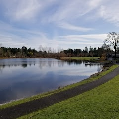
Stop Ideas Near Tumwater
Useful break, food, and waypoint ideas within about 15 miles of the route midpoint.
City of Lacey - City Hall Parking
Olympia Urban Forestry
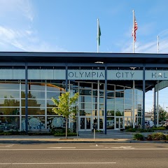
Olympia City Hall
Lacey Community Center
Transit and Meeting Points
Useful pickup, handoff, or rendezvous points close to Tumwater.
Centennial Station
Centralia station
Tacoma Dome Station
Tukwila station
Flight Path Map
This map shows the direct air route between Longview Heights and Seattle. Straight-line distance: 102.84 mi (165.5 km).

#1 Longview Heights
Census designated place
| Population | 3,851 |
| Coordinates | 46.1803900, -122.9570600 |
| Altitude | 270 |
| Country | United States |

#2 Seattle
The eighteenth most populous city in the United States and the center of the Seattle metropolitan area.
| Population | 769,714 |
| Coordinates | 47.6062100, -122.3320700 |
| Altitude | 56 |
| Country | United States |
End: (-122.332143, 47.606309)
Estimated Travel Time
Distance: 207 km by road
| Speed | Time |
|---|---|
| 30 mph (48.3 km/h) | 04h 17m |
| 40 mph (64.37 km/h) | 03h 12m |
| 50 mph (80.47 km/h) | 02h 34m |
| 60 mph (96.56 km/h) | 02h 08m |
| 70 mph (112.65 km/h) | 01h 50m |
| 80 mph (129 km/h) | 01h 36m |
Fuel, Round Trip and CO2
Estimated fuel cost and emissions for this route.
| Fuel | $/gal | One way | Round trip |
|---|---|---|---|
| Regular gas | $5.23 | $23.76 | $47.52 |
| Mid-grade | $5.57 | $25.27 | $50.55 |
| Premium | $5.77 | $26.20 | $52.40 |
| Diesel | $5.47 | $24.82 | $49.64 |
Assumes 8.3 L/100 km (about 28.3 MPG). CO2 is an estimate and varies by vehicle, fuel blend, traffic, and terrain.
Prices in Washington · Jul 24, 2026
Distance to Other Cities
Planning a road trip? See the full trip guide on Trip.ovh — stops, fuel costs, weather, and departure timing.