How far is Lineville, AL from Hoover, AL?
The driving distance from Lineville, AL to Hoover, AL is about 98.1 miles (157.8 km), with a travel time of about 01h 36m by car.
- The straight-line flight distance is about 61.3 miles (98.7 km).
- For a round trip, plan for roughly 03h 12m of driving time before adding stops, traffic, or weather delays.
- A comfortable departure window is usually 8:00 AM to 10:00 AM CDT.
Reverse, save, or send this route
This route works well as a day trip with time at the destination. Copy the route link, send it to another device, or print a clean version before you head out.
This route works well as a day trip with time at the destination.
Flight Distance
Driving Distance
Gas Cost Calculator
Leave and Arrive Planner
Pick a departure time to see your estimated arrival and same-day return window.
Drive time stays fixed at 01h 36m.
A morning start gives you useful time at the destination and keeps the return out of the late evening.
You are leaving earlier than the recommended window, which gives you extra margin for breaks and traffic.
Halfway Point
A useful midpoint for breaks, coffee, or meeting in the middle.
City in Talladega County, Alabama, United States
Route Weather Snapshot
Check the forecast at both ends before you head out.
Partly Sunny
Mostly Sunny
Driving Route Map
The map below follows the saved road route between Lineville and Hoover.
Turn-by-Turn Driving Directions
Step-by-step road directions between Lineville and Hoover.
-
1
Start on Cheaha Road
10 m · 3 sec · Cheaha Road
-
2
Turn right onto Main Street
960 ft · 21 sec · Main Street
-
3
Continue on Main Street
1.2 mi · 2 min · Main Street
-
4
Continue on State Route 9
3.2 mi · 5 min · State Route 9
-
5
Continue on 1st Avenue
1 mi · 2 min · 1st Avenue
-
6
Continue on State Route 9
782 ft · 13 sec · State Route 9
-
7
Turn slight right onto Highway 77
11.2 mi · 15 min · Highway 77
-
8
Continue on Ashland Highway
11 mi · 15 min · Ashland Highway
-
9
Turn right onto Haynes Street
1.1 km · 1 min · Haynes Street
-
10
Turn left onto East Battle Street
1.2 mi · 2 min · East Battle Street
-
11
Turn right onto South East Street
1.4 km · 1 min · South East Street
-
12
Turn left
1.3 km · 58 sec
-
13
Continue straight
9.9 mi · 14 min
-
14
Take the ramp left toward I-20 West: Birmingham
1165 ft · 29 sec
-
15
Merge slight left
30.3 mi · 33 min
-
16
Take the exit slight right toward I 459: Montgomery, Tuscaloosa, Gadsden
1768 ft · 34 sec
-
17
Keep slight left to continue on I 459 South: Montgomery, Tuscaloosa
1.2 km · 1 min
-
18
Merge slight left onto John M. Harbert III Freeway
14.5 mi · 16 min · John M. Harbert III Freeway
-
19
Take the exit slight right toward US 31: Hoover, Pelham
1332 ft · 33 sec
-
20
Keep slight right to continue on US 31 North: Hoover
157 m · 13 sec
-
21
Turn straight onto Montgomery Highway
1.1 mi · 2 min · Montgomery Highway
-
22
Turn left onto Braddock Drive
1162 ft · 53 sec · Braddock Drive
-
23
Turn right onto Spruce Drive
133 m · 25 sec · Spruce Drive
-
24
Turn left onto Whispering Pines Circle
814 ft · 36 sec · Whispering Pines Circle
-
25
Arrive at your destination
0 m · 1 sec · Whispering Pines Circle
Car Route Details
A richer read on the saved driving route between Lineville and Hoover.
Highway-focused drive
Most of the mileage stays on named highways, so the important moments are ramps, exits, merges, and the final local approach.
I-20 West
Merge slight left
30.3 mi · 00h 33m
Route Summary
A quick read on whether this route feels easy, ambitious, or worth planning around.
A comfortable day-trip route
This route works well as a day trip. You can leave in the morning, spend meaningful time at the destination, and still return the same day.
Partly Sunny leaving Lineville and Mostly Sunny near Hoover.
Trip Questions
Direct answers travelers usually want before committing to the drive.
How long does it take to drive from Lineville to Hoover?
The road trip is about 98.1 miles (157.8 km) and usually takes 01h 36m in normal driving conditions.
Is this a same-day trip or an overnight route?
This route works well as a day trip. You can leave in the morning, spend meaningful time at the destination, and still return the same day.
What is the halfway point on this route?
Lincoln is a useful midpoint, sitting about 44.7 miles from Lineville and 53.3 miles from Hoover.
How much longer is the road route than the straight-line distance?
The direct path is about 61.3 miles (98.7 km), while the road route adds roughly 36.8 extra miles because roads do not follow the straight air line.
When is the best time to leave for this route?
A good departure window is usually 8:00 AM to 10:00 AM CDT. If you want a more comfortable same-day return, try to leave by 3:18 PM CDT.
How much will gas cost for this route?
Using about 28.3 MPG, regular gas is estimated at $13.10 one way or $26.21 round trip. Estimated CO2 is about 30.7 kg one way.
What should you check before leaving?
Before you leave, expect Partly Sunny around Lineville and Mostly Sunny near Hoover.
Stop Ideas Near Lincoln
Useful break, food, and waypoint ideas within about 15 miles of the route midpoint.

Pell City Recreation Hall
Lincoln City Hall
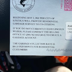
City of Lincoln Water Department
Transit and Meeting Points
Useful pickup, handoff, or rendezvous points close to Lincoln.
Anniston
Birmingham
Flight Path Map
This map shows the direct air route between Lineville and Hoover. Straight-line distance: 61.35 mi (98.73 km).

#1 Lineville
City in Alabama, United States
| Population | 2,221 |
| Coordinates | 33.3106700, -85.7544100 |
| Altitude | 322 |
| Country | United States |

#2 Hoover
The most populous city in Jefferson County, Alabama.
| Population | 85,959 |
| Coordinates | 33.4053900, -86.8113800 |
| Altitude | 176 |
| Country | United States |
End: Whispering Pines Circle (-86.811477, 33.405365)
Estimated Travel Time
Distance: 158 km by road
| Speed | Time |
|---|---|
| 30 mph (48.3 km/h) | 03h 16m |
| 40 mph (64.37 km/h) | 02h 27m |
| 50 mph (80.47 km/h) | 01h 57m |
| 60 mph (96.56 km/h) | 01h 38m |
| 70 mph (112.65 km/h) | 01h 24m |
| 80 mph (129 km/h) | 01h 13m |
Fuel, Round Trip and CO2
Estimated fuel cost and emissions for this route.
| Fuel | $/gal | One way | Round trip |
|---|---|---|---|
| Regular gas | $3.79 | $13.10 | $26.21 |
| Mid-grade | $4.26 | $14.74 | $29.47 |
| Premium | $4.63 | $16.00 | $32.01 |
| Diesel | $5.42 | $18.74 | $37.47 |
Assumes 8.3 L/100 km (about 28.3 MPG). CO2 is an estimate and varies by vehicle, fuel blend, traffic, and terrain.
Prices in Alabama · Jun 27, 2026
Distance to Other Cities
Planning a road trip? See the full trip guide on Trip.ovh — stops, fuel costs, weather, and departure timing.