How far is Frederickson, WA from Auburn, WA?
Fastest route
The distance between Frederickson, Washington, and Auburn, Washington is approximately 20.2 miles (32.5 kilometers). The fastest route, considering traffic conditions, is to take WA-512 E and WA-167 N. Here are some tips and suggestions to help you navigate the journey:
Directions
-
🚗 Start by getting on WA-512 E from 176th St E. Head east on 176th St E toward Canyon Rd E. Use the left 2 lanes to turn left at the 1st cross street onto Canyon Rd E. Continue for 4.1 miles until you reach WA-512 E.
-
🚦 Merge onto WA-512 E. Turn right to merge onto WA-512 E toward Puyallup. Continue on WA-512 E for the next part of your journey.
-
🛣️ Take WA-167 N from WA-512 E. Use any lane to merge onto WA-167 N toward WA-410 E/Seattle/Yakima. Stay on WA-167 N until you reach your exit.
-
🔄 Take the C St. S.W exit from WA-18 E. Once on WA-167 N, continue until you reach the exit for C St. SW. Take this exit to proceed.
-
➡️ Continue on C St SW. Drive to W Main St. After taking the C St. SW exit, follow the road until you reach W Main St.
-
🚦 Turn right onto W Main St. Finally, make a right turn onto W Main St to reach your destination in Auburn, Washington.
Tips & Suggestions
- 🚗 It's always a good idea to check the traffic conditions and plan your journey accordingly to ensure a smoother commute.
- ⛽ Make sure to have enough fuel in your vehicle before embarking on the trip.
- 📱 Consider using a navigation app or GPS device to guide you along the way.
- 🕐 Allow some extra time for unexpected delays or detours that may arise during the journey.
- 🚧 Stay attentive to road signs and follow the indicated directions to avoid any confusion.
- 🚘 Observe the speed limits and drive safely to ensure a comfortable and secure trip.
- 🍽️ If you plan to have a meal or refreshments along the way, consider researching and selecting suitable options in Auburn, Washington.
Reverse, save, or send this route
This is an easy same-day return drive. Copy the route link, send it to another device, or print a clean version before you head out.
This is an easy same-day return drive.
Flight Distance
Driving Distance
Gas Cost Calculator
Leave and Arrive Planner
Pick a departure time to see your estimated arrival and same-day return window.
Drive time stays fixed at 00h 29m.
This is a short drive, so your comfort window is wide. Traffic and current weather matter more than the clock.
This departure sits inside the recommended comfort window for the route.
Halfway Point
A useful midpoint for breaks, coffee, or meeting in the middle.
The second-largest city in Pierce County, Washington.
Route Weather Snapshot
Check the forecast at both ends before you head out.
Partly Sunny then Slight Chance Light Rain
Mostly Cloudy then Slight Chance Light Rain
Driving Route Map
The map below follows the saved road route between Frederickson and Auburn.
Turn-by-Turn Driving Directions
Step-by-step road directions between Frederickson and Auburn.
-
1
Start on the route
69 m · 19 sec
-
2
Turn right
32 m · 10 sec
-
3
Turn sharp right
140 m · 38 sec
-
4
Turn right onto 176th Street East
601 ft · 12 sec · 176th Street East
-
5
Turn left onto Canyon Road East
4.2 mi · 8 min · Canyon Road East
-
6
Take the ramp right toward WA 512 East: Puyallup
1883 ft · 46 sec
-
7
Merge slight left
5.5 mi · 7 min
-
8
Keep slight right to continue on WA 167 North, WA 410 East: Seattle, Yakima
1 km · 1 min
-
9
Merge slight left onto Valley Freeway
7.5 mi · 9 min · Valley Freeway
-
10
Take the exit slight right toward WA 18 East: Auburn
1.6 km · 2 min
-
11
Merge slight left onto State Route 18
138 m · 7 sec · State Route 18
-
12
Take the exit slight right toward C Street Southwest
1705 ft · 44 sec
-
13
At the end of the road, turn left onto C Street Southwest
1648 ft · 49 sec · C Street Southwest
-
14
Turn right onto West Main Street
1135 ft · 33 sec · West Main Street
-
15
Arrive at your destination
0 m · 1 sec · East Main Street
Car Route Details
A richer read on the saved driving route between Frederickson and Auburn.
Turn-heavy local drive
The route has frequent decision points for its length, so lane choice and turn timing will matter more than cruising speed.
Valley Freeway
Merge slight left onto Valley Freeway
7.49 mi · 00h 09m
Route Summary
A quick read on whether this route feels easy, ambitious, or worth planning around.
A short regional drive
This route is short enough to handle as a quick errand, commute, or easy same-day return without much planning overhead.
Partly Sunny then Slight Chance Light Rain leaving Frederickson and Mostly Cloudy then Slight Chance Light Rain near Auburn.
Trip Questions
Direct answers travelers usually want before committing to the drive.
How long does it take to drive from Frederickson to Auburn?
The road trip is about 20.3 miles (32.7 km) and usually takes 00h 29m in normal driving conditions.
Is this a same-day trip or an overnight route?
This route is short enough to handle as a quick errand, commute, or easy same-day return without much planning overhead.
What is the halfway point on this route?
Puyallup is a useful midpoint, sitting about 10.2 miles from Frederickson and 10.2 miles from Auburn.
How much longer is the road route than the straight-line distance?
The direct path is about 15.8 miles (25.5 km), while the road route adds roughly 4.5 extra miles because roads do not follow the straight air line.
When is the best time to leave for this route?
A good departure window is usually 7:00 AM to 7:00 PM PDT. If you want a more comfortable same-day return, try to leave by 7:30 PM PDT.
How much will gas cost for this route?
Using about 28.3 MPG, regular gas is estimated at $3.77 one way or $7.54 round trip. Estimated CO2 is about 6.4 kg one way.
What should you check before leaving?
Before you leave, expect Partly Sunny then Slight Chance Light Rain around Frederickson and Mostly Cloudy then Slight Chance Light Rain near Auburn.
Stop Ideas Near Puyallup
Useful break, food, and waypoint ideas within about 15 miles of the route midpoint.
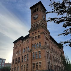
Old City Hall Tacoma
Auburn Building Permits

Auburn Business Licenses
Auburn Community & Event Center
Transit and Meeting Points
Useful pickup, handoff, or rendezvous points close to Puyallup.
Tacoma Dome Station
Tukwila station
Centennial Station
King Street Station
Flight Path Map
This map shows the direct air route between Frederickson and Auburn. Straight-line distance: 15.81 mi (25.45 km).

#1 Frederickson
Census designated place
| Population | 18,719 |
| Coordinates | 47.0962100, -122.3587300 |
| Altitude | 122 |
| Country | United States |

#2 Auburn
The second most populous city in Pierce County, Washington.
| Population | 81,024 |
| Coordinates | 47.3073200, -122.2284500 |
| Altitude | 25 |
| Country | United States |
End: A Street Southeast (-122.228563, 47.307325)
Estimated Travel Time
Distance: 33 km by road
| Speed | Time |
|---|---|
| 30 mph (48.3 km/h) | 00h 40m |
| 40 mph (64.37 km/h) | 00h 30m |
| 50 mph (80.47 km/h) | 00h 24m |
| 60 mph (96.56 km/h) | 00h 20m |
| 70 mph (112.65 km/h) | 00h 17m |
| 80 mph (129 km/h) | 00h 15m |
Fuel, Round Trip and CO2
Estimated fuel cost and emissions for this route.
| Fuel | $/gal | One way | Round trip |
|---|---|---|---|
| Regular gas | $5.23 | $3.77 | $7.54 |
| Mid-grade | $5.57 | $4.01 | $8.02 |
| Premium | $5.77 | $4.16 | $8.31 |
| Diesel | $5.47 | $3.94 | $7.87 |
Assumes 8.3 L/100 km (about 28.3 MPG). CO2 is an estimate and varies by vehicle, fuel blend, traffic, and terrain.
Prices in Washington · Jul 26, 2026
Distance to Other Cities
Planning a road trip? See the full trip guide on Trip.ovh — stops, fuel costs, weather, and departure timing.