How far is City of Janesville, WI from Manitowoc, WI?
The driving distance from City of Janesville, WI to Manitowoc, WI is about 155 miles (249.4 km), with a travel time of about 03h 04m by car.
- The straight-line flight distance is about 118.4 miles (190.6 km).
- For a round trip, plan for roughly 06h 09m of driving time before adding stops, traffic, or weather delays.
- A comfortable departure window is usually 6:00 AM to 8:00 AM CDT.
Reverse, save, or send this route
This drive is better planned with a longer stop or an overnight stay. Copy the route link, send it to another device, or print a clean version before you head out.
This drive is better planned with a longer stop or an overnight stay.
Flight Distance
Driving Distance
Gas Cost Calculator
Leave and Arrive Planner
Pick a departure time to see your estimated arrival and same-day return window.
Drive time stays fixed at 03h 04m.
An early departure helps you fit a real stop into the day without turning the return into a late-night drive.
You are leaving earlier than the recommended window, which gives you extra margin for breaks and traffic.
Halfway Point
A useful midpoint for breaks, coffee, or meeting in the middle.
The thirtieth most populous city in the United States and the center of the Milwaukee metropolitan area.
Route Weather Snapshot
Check the forecast at both ends before you head out.
Chance Rain Showers
Partly Sunny
Driving Route Map
The map below follows the saved road route between City of Janesville and Manitowoc.
Turn-by-Turn Driving Directions
Step-by-step road directions between City of Janesville and Manitowoc.
-
1
Start on East Court Street
582 ft · 21 sec · East Court Street
-
2
Turn right onto Ruger Avenue
2483 ft · 1 min · Ruger Avenue
-
3
Turn right onto South Randall Avenue
2670 ft · 1 min · South Randall Avenue
-
4
Turn left onto East Racine Street
1 mi · 2 min · East Racine Street
-
5
Continue on East Racine Street
136 m · 8 sec · East Racine Street
-
6
Enter the roundabout and take exit 2 toward East Racine Street
44 m · 8 sec · East Racine Street
-
7
Exit the roundabout onto East Racine Street
669 ft · 13 sec · East Racine Street
-
8
Enter the roundabout and take exit 1 toward East Racine Street
34 m · 7 sec · East Racine Street
-
9
Exit the roundabout onto East Racine Street
1.3 mi · 2 min · East Racine Street
-
10
Turn straight
11.2 mi · 15 min
-
11
Continue straight
3.5 mi · 5 min
-
12
Turn left
1929 ft · 47 sec
-
13
Merge slight left
49.9 mi · 55 min
-
14
Keep slight right to continue on I 43, I 94: Milwaukee
1.1 mi · 2 min
-
15
Merge slight left onto North-South Freeway
26.5 mi · 34 min · North-South Freeway
-
16
Continue straight
55.3 mi · 59 min
-
17
Take the exit slight right toward US 151, WI 42 Business, LMCT: Manitowoc, Fond du Lac
1217 ft · 30 sec
-
18
Keep slight right
52 m · 4 sec
-
19
Turn straight onto Calumet Avenue
2 mi · 3 min · Calumet Avenue
-
20
Continue on Washington Street
1.1 mi · 2 min · Washington Street
-
21
Turn right onto South 8th Street
28 m · 4 sec · South 8th Street
-
22
Arrive at your destination
0 m · 1 sec · South 8th Street
Car Route Details
A richer read on the saved driving route between City of Janesville and Manitowoc.
Interchange-aware route
The drive includes several ramps, exits, or merges, so checking the next few maneuvers before busy interchanges is useful.
North-South Freeway
Continue straight
55.3 mi · 00h 59m
Route Summary
A quick read on whether this route feels easy, ambitious, or worth planning around.
A longer out-and-back drive
This is still possible in one day, but it becomes a long driving day. Leaving early and planning your stop window matters more here.
Chance Rain Showers leaving City of Janesville and Partly Sunny near Manitowoc.
Trip Questions
Direct answers travelers usually want before committing to the drive.
How long does it take to drive from City of Janesville to Manitowoc?
The road trip is about 155 miles (249.4 km) and usually takes 03h 04m in normal driving conditions.
Is this a same-day trip or an overnight route?
This is still possible in one day, but it becomes a long driving day. Leaving early and planning your stop window matters more here.
What is the halfway point on this route?
Milwaukee is a useful midpoint, sitting about 77.4 miles from City of Janesville and 77.5 miles from Manitowoc.
How much longer is the road route than the straight-line distance?
The direct path is about 118.4 miles (190.6 km), while the road route adds roughly 36.6 extra miles because roads do not follow the straight air line.
When is the best time to leave for this route?
A good departure window is usually 6:00 AM to 8:00 AM CDT. If you want a more comfortable same-day return, try to leave by 10:50 AM CDT.
How much will gas cost for this route?
Using about 28.3 MPG, regular gas is estimated at $20.63 one way or $41.25 round trip. Estimated CO2 is about 48.6 kg one way.
What should you check before leaving?
Before you leave, expect Chance Rain Showers around City of Janesville and Partly Sunny near Manitowoc.
Stop Ideas Near Milwaukee
Useful break, food, and waypoint ideas within about 15 miles of the route midpoint.
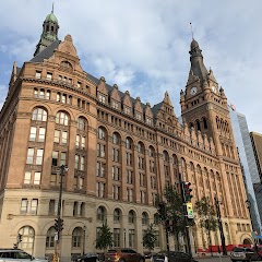
Milwaukee City Hall

West Allis City Hall

City Hall Square Apartments
Transit and Meeting Points
Useful pickup, handoff, or rendezvous points close to Milwaukee.
Milwaukee Intermodal Station
Milwaukee Airport Railroad Station
Sturtevant station
Sheboygan, Wisconsin
Flight Path Map
This map shows the direct air route between City of Janesville and Manitowoc. Straight-line distance: 118.46 mi (190.64 km).

#1 City of Janesville
The most populous city in Rock County, Wisconsin.
| Population | 64,128 |
| Coordinates | 42.6857000, -89.0138500 |
| Altitude | 261 |
| Country | United States |

#2 Manitowoc
City in and the county seat of Manitowoc County, Wisconsin, United States
| Population | 1,077 |
| Coordinates | 44.0886100, -87.6575800 |
| Altitude | 184 |
| Country | United States |
End: Manitowoc (-87.65758, 44.08861)
Estimated Travel Time
Distance: 249 km by road
| Speed | Time |
|---|---|
| 30 mph (48.3 km/h) | 05h 09m |
| 40 mph (64.37 km/h) | 03h 52m |
| 50 mph (80.47 km/h) | 03h 05m |
| 60 mph (96.56 km/h) | 02h 34m |
| 70 mph (112.65 km/h) | 02h 12m |
| 80 mph (129 km/h) | 01h 56m |
Fuel, Round Trip and CO2
Estimated fuel cost and emissions for this route.
| Fuel | $/gal | One way | Round trip |
|---|---|---|---|
| Regular gas | $3.77 | $20.63 | $41.25 |
| Mid-grade | $4.25 | $23.26 | $46.53 |
| Premium | $4.65 | $25.46 | $50.91 |
| Diesel | $5.30 | $29.01 | $58.03 |
Assumes 8.3 L/100 km (about 28.3 MPG). CO2 is an estimate and varies by vehicle, fuel blend, traffic, and terrain.
Prices in Wisconsin · Jun 21, 2026
Distance to Other Cities
Planning a road trip? See the full trip guide on Trip.ovh — stops, fuel costs, weather, and departure timing.