How far is Brent, FL from Marathon, FL?
The driving distance from Brent, FL to Marathon, FL is about 780.9 miles (1256.7 km), with a travel time of about 14h 43m by car.
- The straight-line flight distance is about 547.2 miles (880.7 km).
- For a round trip, plan for roughly 29h 26m of driving time before adding stops, traffic, or weather delays.
- A comfortable departure window is usually 6:00 AM to 7:30 AM CDT.
Reverse, save, or send this route
This drive is better planned with a longer stop or an overnight stay. Copy the route link, send it to another device, or print a clean version before you head out.
This drive is better planned with a longer stop or an overnight stay.
Flight Distance
Driving Distance
Gas Cost Calculator
Leave and Arrive Planner
Pick a departure time to see your estimated arrival and same-day return window.
Drive time stays fixed at 14h 43m.
Starting early still helps, but most travelers will want a longer stop or an overnight stay on a route this long.
You are leaving earlier than the recommended window, which gives you extra margin for breaks and traffic.
Halfway Point
A useful midpoint for breaks, coffee, or meeting in the middle.
Human settlement in Sumter County, Florida, United States of America
Route Weather Snapshot
Check the forecast at both ends before you head out.
Mostly Sunny then Slight Chance Showers And Thunderstorms
Showers And Thunderstorms Likely then Chance Showers And Thunderstorms
Driving Route Map
The map below follows the saved road route between Brent and Marathon.
Turn-by-Turn Driving Directions
Step-by-step road directions between Brent and Marathon.
-
1
Start on East Brent Lane
701 ft · 26 sec · East Brent Lane
-
2
Continue on Brent Lane
2372 ft · 1 min · Brent Lane
-
3
Turn left
1811 ft · 37 sec
-
4
Keep slight left to continue on I 110 North
2883 ft · 55 sec
-
5
Merge slight left onto Reubin O'Donovan Askew Parkway
1.4 km · 1 min · Reubin O'Donovan Askew Parkway
-
6
Keep slight right to continue on I 10 East, FL 291: Tallahassee, Davis Highway
1328 ft · 28 sec
-
7
Keep slight left to continue on I 10 East: Tallahassee
1.1 km · 1 min
-
8
Merge slight left
282.9 mi · 5 hr 3 min
-
9
Take the exit slight right toward I-75 South: Tampa
1959 ft · 37 sec
-
10
Merge slight left
107.2 mi · 1 hr 55 min
-
11
Take the exit slight left toward Florida's Turnpike South, Orlando
261 mi · 4 hr 43 min · Florida's Turnpike
-
12
Take the exit slight right toward Florida's Turnpike Toll South, Homestead
1197 ft · 20 sec · Homestead Extension of Florida's Turnpike
-
13
Keep slight left to continue on Homestead Extension of Florida's Turnpike
46.9 mi · 54 min · Homestead Extension of Florida's Turnpike
-
14
Keep slight left
2930 ft · 1 min
-
15
Merge slight left onto Dixie Highway
19.2 mi · 27 min · Dixie Highway
-
16
Continue on Overseas Highway
59.1 mi · 1 hr 32 min · Overseas Highway
-
17
Turn right onto 39th Street Gulf
546 ft · 30 sec · 39th Street Gulf
-
18
Turn left onto Louisa Street
121 m · 17 sec · Louisa Street
-
19
Arrive at your destination
0 m · 1 sec · Louisa Street
Car Route Details
A richer read on the saved driving route between Brent and Marathon.
Long-distance drive
This route is long enough that fuel, rest stops, weather, and timing matter more than any single maneuver.
I 10 East
Merge slight left
283 mi · 05h 03m
Route Summary
A quick read on whether this route feels easy, ambitious, or worth planning around.
Better with a longer stop
This route is long enough that most travelers will be better off planning an overnight stay or a more deliberate stop window.
Mostly Sunny then Slight Chance Showers And Thunderstorms leaving Brent and Showers And Thunderstorms Likely then Chance Showers And Thunderstorms near Marathon.
Trip Questions
Direct answers travelers usually want before committing to the drive.
How long does it take to drive from Brent to Marathon?
The road trip is about 780.9 miles (1256.7 km) and usually takes 14h 43m in normal driving conditions.
Is this a same-day trip or an overnight route?
This route is long enough that most travelers will be better off planning an overnight stay or a more deliberate stop window.
What is the halfway point on this route?
Wildwood is a useful midpoint, sitting about 390.7 miles from Brent and 390.2 miles from Marathon.
How much longer is the road route than the straight-line distance?
The direct path is about 547.2 miles (880.7 km), while the road route adds roughly 233.7 extra miles because roads do not follow the straight air line.
When is the best time to leave for this route?
A good departure window is usually 6:00 AM to 7:30 AM CDT. Starting early still helps, but most travelers will want a longer stop or an overnight stay on a route this long.
How much will gas cost for this route?
Using about 28.3 MPG, regular gas is estimated at $114.32 one way or $228.64 round trip. Estimated CO2 is about 244.9 kg one way.
Do you cross a time zone on this route?
Yes. There is about a 1 hour time difference between Brent and Marathon, so arrival and return times should be read in local time.
What should you check before leaving?
Before you leave, expect Mostly Sunny then Slight Chance Showers And Thunderstorms around Brent and Showers And Thunderstorms Likely then Chance Showers And Thunderstorms near Marathon.
Stop Ideas Near Wildwood
Useful break, food, and waypoint ideas within about 15 miles of the route midpoint.
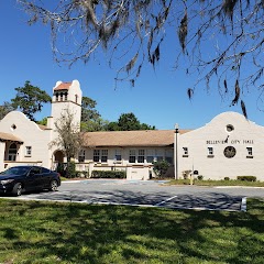
Belleview City Hall Park

Inverness Government Center
City of Belleview
Transit and Meeting Points
Useful pickup, handoff, or rendezvous points close to Wildwood.
Wildwood, Florida
The Villages-Lady Lake, FL
Ocala, Florida
Dade City, Florida
Flight Path Map
This map shows the direct air route between Brent and Marathon. Straight-line distance: 547.27 mi (880.74 km).

#1 Brent
A city located in Pasco County, Florida.
| Population | 21,800 |
| Coordinates | 30.4688100, -87.2360800 |
| Altitude | 34 |
| Country | United States |

#2 Marathon
City in Monroe County, Florida, United States of America
| Population | 8,984 |
| Coordinates | 24.7137500, -81.0903500 |
| Altitude | 1 |
| Country | United States |
End: Marathon (-81.09035, 24.71375)
Estimated Travel Time
Distance: 1257 km by road
| Speed | Time |
|---|---|
| 30 mph (48.3 km/h) | 26h 01m |
| 40 mph (64.37 km/h) | 19h 31m |
| 50 mph (80.47 km/h) | 15h 37m |
| 60 mph (96.56 km/h) | 13h 00m |
| 70 mph (112.65 km/h) | 11h 09m |
| 80 mph (129 km/h) | 09h 44m |
Fuel, Round Trip and CO2
Estimated fuel cost and emissions for this route.
| Fuel | $/gal | One way | Round trip |
|---|---|---|---|
| Regular gas | $4.15 | $114.32 | $228.64 |
| Mid-grade | $4.60 | $126.67 | $253.33 |
| Premium | $4.90 | $134.93 | $269.87 |
| Diesel | $4.35 | $119.89 | $239.77 |
Assumes 8.3 L/100 km (about 28.3 MPG). CO2 is an estimate and varies by vehicle, fuel blend, traffic, and terrain.
Prices in Florida · Jul 27, 2026
Distance to Other Cities
Planning a road trip? See the full trip guide on Trip.ovh — stops, fuel costs, weather, and departure timing.