Denver, Iowa
Denver: city in Iowa, US
About
Denver is a city located in the county of Bremer in the U.S. state of Iowa. Its population at the 2010 census was 1,780 and a population density of 416 people per km². After 10 years in 2020 city had an estimated population of 1,879 inhabitants.

Quick Facts about Denver
| Population | 1,879 (2020) |
| Country | United States of America |
| State | Iowa (United States) |
| County | Bremer County |
| Postal code | 50622 |
| Phone Area Codes | 319 |
| Area | 4.28 km2 |
| Latitude & Longitude | 42.6714,-92.3374 |
| Altitude | 948 feet / 289 meters |
| Time Zone | America/Chicago |
| Local time | 06:19:51 (17th July 2026) |
| Density | 439 Pop. per km² as of 2020 |
| Population growth | 5.27% (2010-2020) |
| Weather | 90℉ Sunny 7-days weather |

Geography
Denver is located at 42°40'17"N 92°20'15"W (42.6713700, -92.3374000).
Denver map
Official website of Denver
Official WebsiteDemographics
The population of Denver increased by 5.27% in 10 years.
| Year | Population | % Change | Method |
|---|---|---|---|
| 2010 | 1,780 | - | census |
| 2011 | 1,769 | -0.62% | estimation process |
| 2012 | 1,783 | 0.79% | estimation process |
| 2013 | 1,791 | 0.45% | estimation process |
| 2014 | 1,807 | 0.89% | estimation process |
| 2015 | 1,820 | 0.71% | estimation process |
| 2016 | 1,824 | 0.22% | estimation process |
| 2017 | 1,830 | 0.33% | estimation process |
| 2018 | 1,847 | 0.92% | estimation process |
| 2019 | 1,856 | 0.48% | estimation process |
| 2020 | 1,879 | 1.22% | estimation process |
Services and Civic Places in Denver
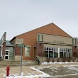
1Denver City Hall
100 Washington St, Denver, IA 50622 View details
Phone: +13199845642 | Website available
Nearby Schools and Colleges
Schools and campuses linked to Denver, IA. Select a name to open its map and contact details.
| Code | Name | City | ZIP |
|---|---|---|---|
| 154527 | Wartburg College | Waverly (IA) | 50677-0903 |
Closest post offices linked to Denver.
| Post Office Name | City | ZIP |
|---|---|---|
| Denver Post Office | Denver (IA) | 50622 |
Other places with the same name (6)
- Denver, Colorado The twentieth most populous city in the United States and the center of the Denver metropolitan area. with a population of 735,538 people.
- Denver, Pennsylvania borough in northeastern Lancaster County, Pennsylvania, United States with a population of 3,831 people.
- Denver, North Carolina township in Lincoln County, North Carolina with a population of 2,309 people.
- Denver, Indiana town in Indiana, United States with a population of 462 people.
- Denver, Illinois human settlement in Illinois, United States of America with a population of 390 people.
- Denver, Missouri village in Missouri, United States with a population of 35 people.
Other cities in Bremer County
Cities, towns, neighborhoods & other populated places in Bremer County , IA.
| City Name | Population | Title |
|---|---|---|
| Waverly | 10,298 | City in Bremer County, Iowa, United States |
| Sumner | 1,965 | City in Bremer County, Iowa, United States of America |
| Tripoli | 1,375 | City in Iowa, United States |
| Janesville | 996 | City in Iowa |
| Readlyn | 854 | Human settlement in Bremer County, Iowa, United States of America |
| Plainfield | 413 | City in Iowa, United States |
| Frederika | 205 | Township in Bremer County, Iowa |
Distance to Other Cities
Denver distances to largest Iowa cities
- Des Moines
- Cedar Rapids
- Davenport
- Sioux City
- Iowa City
- Ankeny
- West Des Moines
- Waterloo
- Ames
- Council Bluffs
Map & Images (more maps)
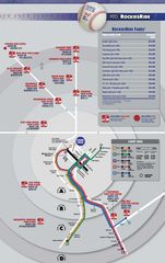
Denver Bus Map (rockiesride)
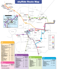
Denver Bus Map (skyride)
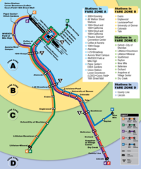
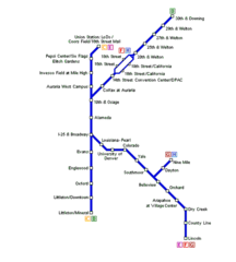
Denver Light Rail Map